This research project looks at two intertwined processes in the history of North American and German geography from the early 20th century to the 1970s. First, the shifting hegemonic relations between “theory-importer” United States and “theory-exporter” German human geography, in which a formerly peripheral US geography triumphed over its German counterpart and became hegemonic after WWII; second, this shift was connected to the post-WWII quantitative revolution in US and Canadian geography during the 1950s and 1970s, in which the discipline became a mathematical and rigorous Cold War spatial science. This project follows a transnational historical perspective in the historical geographies of scientific knowledge to look at how geographical knowledge circulated and interacted between North America and Germany. It does so by analyzing the influence and circulation of German geographical knowledge and location theories, most notably central place theory in urban and regional planning, which became a paradigmatic theory of Cold War geography internationally, and later re-influenced German geography from the late 1960s from the US. The research project is based on archival research and career path interviews with scholars connected to the quantitative revolution.
Címke: American geography
Two new abstracts sent to ICHG2018 and AAG2018
My latest plan is to send two abstracts to the 17th International Conference of Historical Geographers in Warsaw, July 15-20 and one – the latter abstract here provided – to the Association of American Geographers Annual Meeting in New Orleans, April 10-14 in 2018. In the first case, the first abstract will hopefully be part of the following session:
– SESSION –
Global Histories of Geography 1930–1990
Convenors: Ruth Craggs (King’s College London) and Hannah Neate (Manchester Metropolitan University)
Reflecting on the key centres associated with the emergence of geography as a spatial science in the 1960s Barnes (2002, 508) remarked: “Why are places in Africa not on there, or Asia, or Australasia?” thereby highlighting significant gaps in disciplinary histories and accounts of geography’s development in the second half of the twentieth century. By way of response, this session aims to highlight work into the ‘global’ histories of geography in the period 1930-1990, a period marked by geopolitical transitions including WWII, decolonization and the end of the Cold War. We are looking to make links with scholars who are carrying out research on the history and practice of geography, specifically in submissions that explore scholarly communities of geographers whose contribution to the development of geography in the twentieth century often goes unrecognised in the ‘canon’ of geographical research.
Possible themes for papers:
- Papers focusing on geographers from the global South, Indigenous geographers in settler states, Asian geographies and geographers, geographers from the former Eastern Block
- Biographies of individuals or groupings of geographers
- Accounts that highlight how geography was being pursued in other ‘centres’
- The role and development of national and international disciplinary associations and networks
- Geographical knowledge, expertise and intersections with decolonization and the end of the Cold War
– ABSTRACTS –
Historical geographies of the “quantitative revolution”: Towards a transnational history of central place theory
Geography’s “quantitative revolution” has been a true textbook chronicle in the discipline’s canonical history. However, historical research has only recently seriously begun to unravel the geographical contexts of its emergence, which is complicated by the simplified narratives that emerged in critical revisionism from the 1970s. This paper offers an interpretative framework from the perspective of the historical geographies of scientific knowledge (HGSK), by focusing on Christaller’s central place theory (CPT) to deconstruct the common Anglo-American narrative, arguing that it has concealed other contexts in the “Second” and “Third” worlds. Early applications (especially in Germany, Poland, Netherlands, Israel) and the wider European discourse of “central places” call for a reevaluation of the canonized narratives of CPT. The globalization of CPT is interpreted through the rising American hegemony in the early Cold War era, which led to the Americanization of German location theories in modernization theory discourse. Networks behind the American, British and Canadian centres show the importance of European locations, such as the Swedish hub in Lund, and the “planning laboratories” of Asian, South American and African contexts after decolonization. Soviet and Eastern Bloc reformism and the institutionalization of regional planning from the late 1950s summoned CPT in the service of centralized state planning, and ignited debates of adaptability between “socialist” and “capitalist” contexts. By reflecting on some of these cases, this paper argues for a transnational history of CPT by readdressing issues of narrativity and historical periodization, and shows the need for provincializing and decolonizing dominant Anglo-American geographical knowledge production.
“The Ghana job”: Opening Hungary to the developing world
Based on interviews, archival and media sources, this paper looks at how post-WWII socialist Hungary developed foreign economic relations with decolonized countries, by focusing on the emergence of Hungarian development and area studies and development advocacy expertise towards developing countries. The paper’s case study is the Centre for Afro-Asian Research (CAAR) founded at the Hungarian Academy of Sciences in 1963 – from 1973 the Institute for World Economy (IWE) – parallel to similar institutions founded in the Soviet Union and other Eastern Bloc states. CAAR was established as a government think tank by József Bognár, a close friend to Prime Minister János Kádár and perhaps one of the most important figures in socialist era Hungarian reform economics and foreign policy-making. The institute rose as a consequence of the “Ghana job”: Hungarian economists led by Bognár developed the First Seven-Year Plan of Ghana in 1962. The associates of CAAR and IWE promoted export-oriented growth against import-substitution industrialization and summoned geographical development concepts such as “poorly developed countries”, “dependency”, “semiperiphery”, “open economies”, or “small countries” as alternatives to the Cold War categories of “capitalist” and “socialist” world systems. This shift in geographical knowledge production is connected to the geopolitical contexts of the Sino-Soviet split, the Khrushchevian “opening up” of foreign relations, the emergence of the “Third World”, and also the 1956 revolution in the case of Hungary. The role of Ghana and the Eastern Bloc is connected to the 1960s wave of transnational development consultancy and strategies of “socialist globalization”.
Christaller in Africa
Peculiar or not so peculiar stories
Previously I wrote about the stories of Károly Perczel and László Huszár. Both were Hungarian architects, urbanists and regional planners, but the latter was also involved in planning projects in the Third World. His life story is incredibly interesting: he was an 1956 Hungarian emigré living in the UK, and after some years of university study and organization of (unsuccessful) emigrant resistance, he moved to applied urban and regional planning. Huszár’s most influential work (to him) was his first, 5-year assignment in Ghana from 1961 to redevelop a part of the country’s settlement system due to the building of the huge Volta dam. This dam was to provide cheap electricity for developing industry and infrastructure. As Huszár said in his interview (Nóvé 2001), the Ghana job supported by the United Nations meant a radical change in his life: it was his first real “planning” assignment, and from then on he focused all his efforts to urban and regional development in the Third World, mostly in East and North Africa, South and Southeast Asia (Indonesia, Thailand, Malaysia, Brunei).
Apart from his Hungarian context, Huszár’s story was far from unique. It was rather typical of human geographers in the US and UK to spend a few months or years in a so-called “Third World” or “developing” country and do some planning work in projects funded by post-WWII international organizations. Such organizations, formally seeking humanitarian aims, were the prime locutors of channeling American development funds and expertise into these peripheral, decolonized areas. The rising American hegemony was incited by rival Communist geopolitical and developmental aims, as expressed by W. W. Rostow’s “stages of growth” in his influential “Anti-Communist Manifesto” in 1960. This expanding US economy implied the development of basic welfare in developing countries in order to provide new markets for American goods, and the transfer or selling of manufacturing technologies (especially light industry) and providing huge loans. All this included applying top-of-the-notch Western planning theories in the quest for “modernizing traditional societies” in Weberian or Marxian fashion.
American “quantifiers” in Africa
The first pioneering works on the application of sophisticated mathematical techniques and statistics on spatial planning issues emerged in the second half of the 1950s. This was an effect of the “new geography” emerging after WWII in American (and not much later, UK) geography, which was soon to be called the “quantitative revolution.” To deal with vast amount of data, they needed computers and a staff heavily trained in statistics and modelling.
While David Harvey was working endlessly on his Explanation in Geography (1969), a very important work which summarized the main philosophical tenets of the “scientific method,” many others, such as Edward Soja were applying the same theories in development projects throughout the Third World. Although both Harvey and Soja turned out to be a Marxist, their young socialization with humanitarian liberalism led them to a belief in scientific methods towards social progress. Soja’s first big project was in Kenya (also by United Nations), from which he wrote his PhD at Syracuse University, and a year later published a book, The Geography of Modernization in Kenya (1968). His short biography explains the context:
“Soja attended Syracuse University where, among his teachers, was Eduardo Mondlane, the first Mozambican to hold a PhD and the founder of the Mozambican liberation movement, FRELIMO. At Syracuse, Mondlane developed the East African Studies Program which caught the interest of Soja.
In the early 1960s, Soja went to Kenya to study urban planning as the country underwent a transition from a traditional society to more modern forms of social, economic, and political organization. On return from fieldwork in February 1965 he taught about East Africa, as well as quantitative techniques.” (AAG)
Similar stories can be sometimes found in popular textbooks, like Approaches to Human Geography, where Gerard Rushton tells about his professional career. He received his training in mathematical geography and location theories at Iowa University, which was one of the prime nodes of the so-called “quantitative revolution” in the US during the 1950s and 1960s. Early in his professional career, he got involved in an important project:
“In 1970, the Ford Foundation asked if I would review a project in India that was designed to facilitate the provision of services to villages in areas where the green revolution was being promoted. The project was implemented by the Government of India and the Ford Foundation provided technical support. The project organizers in India stated that their approach was based on central place theory. I criticized their plan roundly, mainly on the grounds that it appeared to be trying to lay hexagons over the regions of interest to promote the development of villages close to the theoretical nodes. … Working for the Foundation was unlike academic work and living in their guest house and meeting the people coming and going from some of the best universities in the US and elsewhere was an interesting experience. … Two NSF grants allowed us to continue working in India and Nigeria on problems of locating services in developing countries.” (Rushton 2006: 175)
Concealing the periphery: “Second” and “Third” Worlds
In spite of these stories, if you read into the mainstream Anglophone human geography textbook narratives on how the story of the “quantitative revolution” is told, everything is about North American and British developments, because these were the sites of the so-called “revolution” (a self-invented term). Other pieces of this story were also remembered, extending to the Western and Northern European contexts. Notable is the relatively recent spotlight on Christaller’s Nazi past (Barnes 2006), the inclusion of which is a truly American characteristic (Nazis were evil), as it was already researched in Germany from the 1980s. Although these mathematical theories, like input-output methods, linear programming, probabilistic diffusion (Monte Carlo simulations), location theories and central place theory, etc. were deemed by these “new geographers” as universal scientific tools serving progressive change, you can findabsolutely nothing in mainstream narratives of its application in the so-called Second and Third Worlds. Maybe an initial remark of its Nazi past, the first Dutch applications, or very recently a pinch of the Israeli story, but considering Europe, still heavy silence sleeps upon the Eastern European case or its wider socialist applications. Completely nothing is told about African, Asian or South American contexts.
This is very strange, since in the 1960s and 1970s saw huge debates and strong curiousity between the “East” and the “West” on urban and regional planning methods. Since the application of modernization theories needed huge amounts of statistical data, developed infrastructure, high technology and expertise, and – most importantly – a centralized government to carry out these plans, discussions were often framed in the “market or plan” debate. The West was interested in the planned application of these theories, while the East was interested in the high scientific and technological value of Western methods. This was ideologically played out in the US’s and USSR’s race over developing the Third World for obvious economic and political reasons. But to create a viable economy with marketable goods from scratch, one needed a strong state apparatus. How could efficient and long-term planning be achieved under the flexible conditions of world capitalism? This was the question raised not only by Western capitalists, but also their socialists counterparts, especially Eastern European countries which sought to turn to “market socialism” and export-oriented growth, and consequently searched for various strategies of integrating into the world economy (flexible price allocation, raised autonomy of companies, selective development of profitable sectors, etc.). The main arguments for relatively small Eastern European state-socialist countries seeking export-led development – such as Hungary – was that complex planning of the whole economy could be more easily carried out due to their small territory but high quality of professionals. Many Third World countries, such as Ghana under Kwame Nkrumah in the 1960s asked for professional assistance from Hungarian economists (e.g. József Bognár) to help model their development strategies on Eastern European trajectories. In Ghana, the Volta dam served as an important prequisite for providing the economic momentum for these developments.
One of my dissertation’s main theses is that mainstream narratives of the “centre” leave out “peripheral” contexts, which were actually the preconditions for developments such as the (American) “quantitative revolution.” Instead, we should look at the interdependent relations between the “centre” and the “periphery.” We are offered accounts on the knowledge base and developments of Anglo-Americanized theories, but the specific ways these, such as central place theory got internationalized and globalized (or, we must add, contested) are yet concealed. Meanwhile, the narrative currency of the “quantitative revolution” is still high both in the West and postsocialist Eastern Europe: there is a universal appeal towards useful quantitative tools offering control over economic development, investments and capital accumulation, but without any questioning of the political economic relations serving as their aims and contexts of application. Behind the scences, the huge impetus of the American “revolution” in the 1950s and 1960s was the expanding US economy into the Third World, and the development of post-WWII international organizations (e.g. UN, World Bank) which provided both the humanitarian ideology, transnational infrastructure and development funds for modernization projects. While the “Second World” in Eastern Europe and the Soviet Union were trying to refine the same ideas and theories for “socialist” economies, the “Third World” became a “living laboratory” – to use Helen Tilley’s words – for both so-called “capitalist” and “socialist” countries’ development trajectories.
Americans were pioneering this kind of mathematical and applied spatial research on identifying central places in Africa, which showed a remarkable postcolonial continuity by managing and administrating African territories. Central place theory could be used to reorganize the settlement hierarchy in a “rational” form, solving the urban-rural divide and setting a decentralized economy. For decentralization, however, a centralized state government was needed. “Rational” planning also needed the precise assessment of resources, and huge amounts of standardized data, which could only be retrieved through state censuses. Regional planners were important actors in opting for reliable data in their unquenchable hunger for numbers to be modelled and mapped.
The South African urban hierarchy
Take this great example from South Africa. An American geographer, Davies (1967) conducted a research to map the central places of the “country,” based on the first pioneering methods from the US, and the recent Population Census data taken in 1960. Contexts such as these were the perfect sandbox training for the planner seeking to test and verify deductive mathematical hypotheses. Suggestions could be made, as were done by Davies, on how to refine these methods developed in the US. The empirical and applied challenges posed by these environments became valuable experiences that could be circulated back to the “centre” in – as Bruno Latour would say – expanding cycles of accumulation. The African “test site” was an important element in expanding both the global verification of the theory through its “translation” into different environmental and political economic contexts, and also the expansion of a group of international experts, who could circulate through, adapt and connect these different contexts in transnational networks.
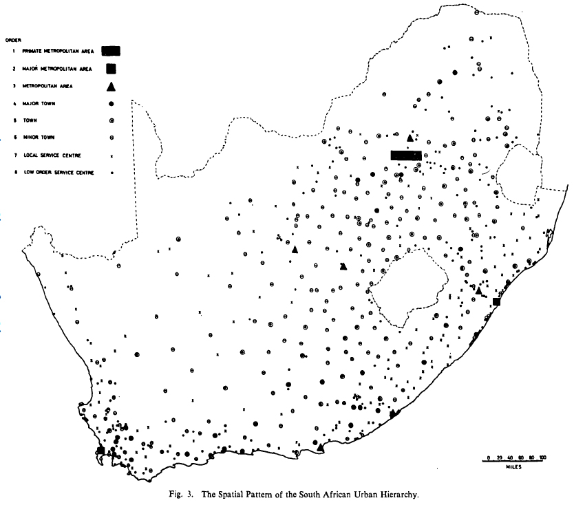
Central places of South Africa (Davies 1967: 16)
In addition, Davies notes that before Americans, Germans have already conducted such research:
“Research thus far has, however, not contributed a central place analysis of South Africa. This paper is concerned with the postulation of an urban hierarchy for the country as the first phase of a more comprehensive study of the detailed functional and spatial inter-relationship of its towns. … The only published central place study of South Africa is one by Carol in 1952 for the Central Karoo region. Carol, H. Das Agrageographische Berachtungssystem. Ein Beitrag zur Landschaftkundlichen Methodik dargelegt am Beispiel der in Südafrika. Geographica Helvetica, 1. (1952), p. 17-67.” (Davies 1967: 9, 18)
Since central place theory was developed in the end of the 1920s and early 1930s, Germans or other Europeans might have done some important research on African territories before the Americans did. But I have no knowledge of this yet. Nevertheless, colonial powers such as the British and the French were not much into this research, while location theories and central place theory mostly originated from German authors.
Hans Carol’s (1915-1971) article is a thrilling and very dense piece. Carol was actually a Swiss geographer working in Zürich, who later moved to York University (Toronto, Canada) in 1962 (see records). His study presents a full geographical account of the Karoo region in Hettnerian fashion, while also applying the new and modern methods of central place theory, which was far from common in geographical studies in the Europe. Apart from using Christaller and Bobek, it cites relevant studies from contemporary British authors who also adapted Christaller’s ideas (Smailes 1946; Dickinson 1947), and even refers to American geography (R. Hartshorne), but does not cite very recent American research (e.g. Ullman 1941), which was still immature, distant and peripheral from the European centre at that time. His first big study was on the area around Zürich, and he used this experience to do an analysis of the functional spatial structure of the Karoo region in South Africa. I think this whole story is a very good example of why we need to look at the entangled histories of how knowledge is made and legitimated through global or transnational connections.
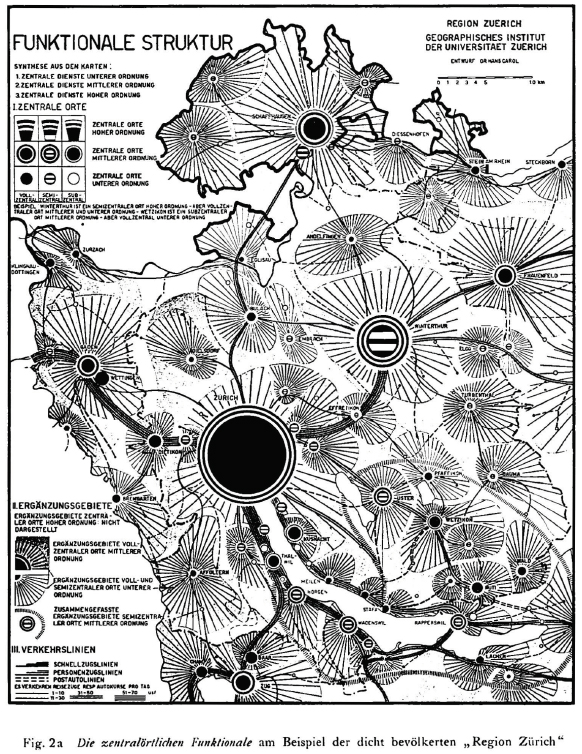
The central places in the region of Zürich (Carol 1952: 30)
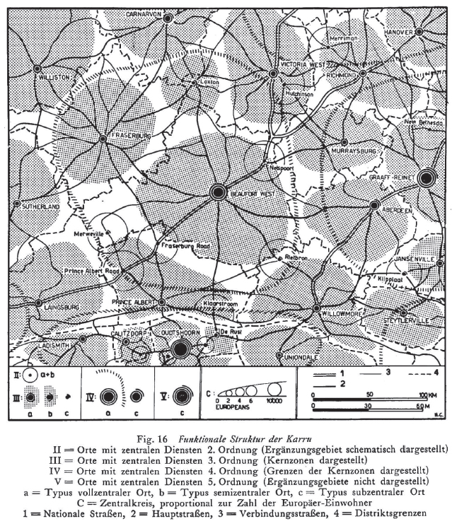
The central places of the Karoo region in South Africa (Carol 1952: 60)
Davies, R. J. (1967): The South African Urban Hierarchy. South African Geographical Journal, 49(1): 9-20.
Dickinson, R. E. (1947): City, region and regionalism. A geographical contribution to human ecology. London.
Nóvé Béla (2001): Interview with László Huszár (1932-2007). Record No. 748. Oral History Archives, Budapest.
Rushton, Gerard (2006): Institutions and Cultures. In : Stuart Aitken and Gill Valentine (eds.): Approaches to Human Geography. SAGE. pp. 171-177.
Smailes, A. E. (1946): The urban mesh of England and Wales. The Institute of British Geographers, transactions and papers, 5. 85—101.
Ullman, E. (1941): A Theory of Location for Cities. American Journal of Sociology, 46(6), 853-864.
Richard Hartshorne’s racism
In my research, I’ve done some investigation on the debates of American geography between the 1920s and 1950s. Today, I’ve just encountered an incredible quote from the eminent American geographer, Richard Hartshorne, author of a once almost biblical text on the history of geography, The Nature of Geography (1939), and who was active during the noted period. This is the guy in his authentic environment and his tome.


According to textbook narratives and all academic pieces on him to date, as a political geographer he was generally troubled by environmental determinists and eugenicists of the time, and I previously thought of him as a sort of liberal, who was against racial prejudice and the tenets of physical anthropology. As the story goes, many geographers such as Hartshorne became increasingly disillusioned by these insidious thoughts, the abandonment of which was further encouraged by the growing mainstream American antipathy for Nazism and Fascism in Europe in the mouth of WWII. This is the American narrative.
Now, here’s the quote from the first page of the 1938 article in question:
“However, in place of this problem of national minorities the United States has more permanent problems of racial minorities – problems in a form essentially unknown in Europe. The differences between French and English, Germans and Poles, or even Swedes and Finns, Rumanians and Magyars are essentially cultural, not biological. Germans have become French and Poles have become Germans in two generations. So far as appearance is concerned, the barber and the tailor can make the change in a day. But no amount of education can change into white Americans the descendants of the negroes who arrived in Virginia before the Pilgrims landed at Plymouth, just as no beauty shop can make a fullblood negro look like a white person.” (p. 276)
Hartshorne’s racial definitions here are purely statistical, and he does not provide any analytical arguments for the distribution of races, only a descriptive account on the data and some basic geographical factors connected to regional divisions in labour and industry. He uses the definitions and data of the United States Bureau of the Census, 1930. As he explains:
“We shall not enter into the argument regarding what is meant by “race.” Our interest is in social and political situations that arise from obvious biological differences, and we can therefore accept the ordinary interpretation of racial terms as used in this country. In the United States apparently the only definition of a negro is one who is known to be a negro; i.e. one who, either because of obvious physical characteristics, chiefly color, or because of known origin, is recognized as having any degree of negro ancestry, regardless of how much white ancestry he may also have.” (p. 277)
The same is the case with the other races identified, the Mexicans, Indians and “Orientals”. For example, Mexicans are said to be Indians speaking Spanish, who could be “recognized on sight”. The only thing he argues against concerning some very racist ideas is climatic determinism in the “negro case”:
“But it is clear from the map that this is not a direct reflection of climate, as some foreign observers have supposed. The large number of negroes in Northern cities cannot be dismissed as exceptions; nor can the absence of negroes in many Southern districts be explained climatically.” (p. 277)
Why is this whole stuff flabbergastingly interesting? Well… as previously noted, my humble impression is that
there is still almost complete silence on the racial ideas of American geographers who were NOT commemorated as well-known eugenicists or environmental determinists of the time.
You can read about the racisms of Ellsworth Huntington, Griffith Taylor, or maybe the more moderate Ellen Churchill Semple. Neil Smith has written on Isiah Bowma n’s racism in his The American Empire (2004), but I could find only some littered personal accounts on the racism of other important geographers, like Carl Ortwin Sauer (this calls for another post). There aren’t even traces of reflection on these issues in any of the most prominent accounts on the history of American geography, like in David Livingstone’s The Geographical Tradition (1992), Ron J. Johnston’s (and James D. Sidaway’s) Geography and Geographers (2015), Richard Peet’s Modern Geographical Thought (1998), Geoffrey J. Martin’s American Geography and Geographers (2015) or his All Possible Worlds (2005), just to name a few, and nor in Reflections on Richard Hartshorne’s Nature of Geography (1989).
In sum, it seems to me that the reevaluation of the racial thought of a wider field of American geographers is yet to be done in light of contemporary racial discourses and political thought.
By the way, here are the maps, just for fun.
