Christaller in Africa

Peculiar or not so peculiar stories

Previously I wrote about the stories of Károly Perczel and László Huszár. Both were Hungarian architects, urbanists and regional planners, but the latter was also involved in planning projects in the Third World. His life story is incredibly interesting: he was an 1956 Hungarian emigré living in the UK, and after some years of university study and organization of (unsuccessful) emigrant resistance, he moved to applied urban and regional planning. Huszár’s most influential work (to him) was his first, 5-year assignment in Ghana from 1961 to redevelop a part of the country’s settlement system due to the building of the huge Volta dam. This dam was to provide cheap electricity for developing industry and infrastructure. As Huszár said in his interview (Nóvé 2001), the Ghana job supported by the United Nations meant a radical change in his life: it was his first real “planning” assignment, and from then on he focused all his efforts to urban and regional development in the Third World, mostly in East and North Africa, South and Southeast Asia (Indonesia, Thailand, Malaysia, Brunei).

Apart from his Hungarian context, Huszár’s story was far from unique. It was rather typical of human geographers in the US and UK to spend a few months or years in a so-called “Third World” or “developing” country and do some planning work in projects funded by post-WWII international organizations. Such organizations, formally seeking humanitarian aims, were the prime locutors of channeling American development funds and expertise into these peripheral, decolonized areas. The rising American hegemony was incited by rival Communist geopolitical and developmental aims, as expressed by W. W. Rostow’s “stages of growth” in his influential “Anti-Communist Manifesto” in 1960. This expanding US economy implied the development of basic welfare in developing countries in order to provide new markets for American goods, and the transfer or selling of manufacturing technologies (especially light industry) and providing huge loans. All this included applying top-of-the-notch Western planning theories in the quest for “modernizing traditional societies” in Weberian or Marxian fashion.

American “quantifiers” in Africa

The first pioneering works on the application of sophisticated mathematical techniques and statistics on spatial planning issues emerged in the second half of the 1950s. This was an effect of the “new geography” emerging after WWII in American (and not much later, UK) geography, which was soon to be called the “quantitative revolution.” To deal with vast amount of data, they needed computers and a staff heavily trained in statistics and modelling.

While David Harvey was working endlessly on his Explanation in Geography (1969), a very important work which summarized the main philosophical tenets of the “scientific method,” many others, such as Edward Soja were applying the same theories in development projects throughout the Third World. Although both Harvey and Soja turned out to be a Marxist, their young socialization with humanitarian liberalism led them to a belief in scientific methods towards social progress. Soja’s first big project was in Kenya (also by United Nations), from which he wrote his PhD at Syracuse University, and a year later published a book, The Geography of Modernization in Kenya (1968). His short biography explains the context:

“Soja attended Syracuse University where, among his teachers, was Eduardo Mondlane, the first Mozambican to hold a PhD and the founder of the Mozambican liberation movement, FRELIMO. At Syracuse, Mondlane developed the East African Studies Program which caught the interest of Soja.

In the early 1960s, Soja went to Kenya to study urban planning as the country underwent a transition from a traditional society to more modern forms of social, economic, and political organization. On return from fieldwork in February 1965 he taught about East Africa, as well as quantitative techniques.” (AAG)

Similar stories can be sometimes found in popular textbooks, like Approaches to Human Geography, where Gerard Rushton tells about his professional career. He received his training in mathematical geography and location theories at Iowa University, which was one of the prime nodes of the so-called “quantitative revolution” in the US during the 1950s and 1960s. Early in his professional career, he got involved in an important project:

“In 1970, the Ford Foundation asked if I would review a project in India that was designed to facilitate the provision of services to villages in areas where the green revolution was being promoted. The project was implemented by the Government of India and the Ford Foundation provided technical support. The project organizers in India stated that their approach was based on central place theory. I criticized their plan roundly, mainly on the grounds that it appeared to be trying to lay hexagons over the regions of interest to promote the development of villages close to the theoretical nodes. … Working for the Foundation was unlike academic work and living in their guest house and meeting the people coming and going from some of the best universities in the US and elsewhere was an interesting experience. … Two NSF grants allowed us to continue working in India and Nigeria on problems of locating services in developing countries.” (Rushton 2006: 175)

Concealing the periphery: “Second” and “Third” Worlds

In spite of these stories, if you read into the mainstream Anglophone human geography textbook narratives on how the story of the “quantitative revolution” is told, everything is about North American and British developments, because these were the sites of the so-called “revolution” (a self-invented term). Other pieces of this story were also remembered, extending to the Western and Northern European contexts. Notable is the relatively recent spotlight on Christaller’s Nazi past (Barnes 2006), the inclusion of which is a truly American characteristic (Nazis were evil), as it was already researched in Germany from the 1980s. Although these mathematical theories, like input-output methods, linear programming, probabilistic diffusion (Monte Carlo simulations), location theories and central place theory, etc. were deemed by these “new geographers” as universal scientific tools serving progressive change, you can findabsolutely nothing in mainstream narratives of its application in the so-called Second and Third Worlds. Maybe an initial remark of its Nazi past, the first Dutch applications, or very recently a pinch of the Israeli story, but considering Europe, still heavy silence sleeps upon the Eastern European case or its wider socialist applications. Completely nothing is told about African, Asian or South American contexts.

This is very strange, since in the 1960s and 1970s saw huge debates and strong curiousity between the “East” and the “West” on urban and regional planning methods. Since the application of modernization theories needed huge amounts of statistical data, developed infrastructure, high technology and expertise, and – most importantly – a centralized government to carry out these plans, discussions were often framed in the “market or plan” debate. The West was interested in the planned application of  these theories, while the East was interested in the high scientific and technological value of Western methods. This was ideologically played out in the US’s and USSR’s race over developing the Third World for obvious economic and political reasons. But to create a viable economy with marketable goods from scratch, one needed a strong state apparatus. How could efficient and long-term planning be achieved under the flexible conditions of world capitalism? This was the question raised not only by Western capitalists, but also their socialists counterparts, especially Eastern European countries which sought to turn to “market socialism” and export-oriented growth, and consequently searched for various strategies of integrating into the world economy (flexible price allocation, raised autonomy of companies, selective development of profitable sectors, etc.). The main arguments for relatively small Eastern European state-socialist countries seeking export-led development – such as Hungary – was that complex planning of the whole economy could be more easily carried out due to their small territory but high quality of professionals. Many Third World countries, such as Ghana under Kwame Nkrumah in the 1960s asked for professional assistance from Hungarian economists (e.g. József Bognár) to help model their development strategies on Eastern European trajectories. In Ghana, the Volta dam served as an important prequisite for providing the economic momentum for these developments.

One of my dissertation’s main theses is that mainstream narratives of the “centre” leave out “peripheral” contexts, which were actually the preconditions for developments such as the (American) “quantitative revolution.” Instead, we should look at the interdependent relations between the “centre” and the “periphery.” We are offered accounts on the knowledge base and developments of Anglo-Americanized theories, but the specific ways these, such as central place theory got internationalized and globalized  (or, we must add, contested) are yet concealed. Meanwhile, the narrative currency of the “quantitative revolution” is still high both in the West and postsocialist Eastern Europe: there is a universal appeal towards useful quantitative tools offering control over economic development, investments and capital accumulation, but without any questioning of the political economic relations serving as their aims and contexts of application. Behind the scences, the huge impetus of the American “revolution” in the 1950s and 1960s was the expanding US economy into the Third World, and the development of post-WWII international organizations (e.g. UN, World Bank) which provided both the humanitarian ideology, transnational infrastructure and development funds for modernization projects. While the “Second World” in Eastern Europe and the Soviet Union were trying to refine the same ideas and theories for “socialist” economies, the “Third World” became a “living laboratory” – to use Helen Tilley’s words – for both so-called “capitalist” and “socialist” countries’ development trajectories.

Americans were pioneering this kind of mathematical and applied spatial research on identifying central places in Africa, which showed a remarkable postcolonial continuity by managing and administrating African territories. Central place theory could be used to reorganize the settlement hierarchy in a “rational” form, solving the urban-rural divide and setting a decentralized economy. For decentralization, however, a centralized state government was needed. “Rational” planning also needed the precise assessment of resources, and huge amounts of standardized data, which could only be retrieved through state censuses. Regional planners were important actors in opting for reliable data in their unquenchable hunger for numbers to be modelled and mapped.

The South African urban hierarchy

Take this great example from South Africa. An American geographer, Davies (1967) conducted a research to map the central places of the “country,” based on the first pioneering methods from the US, and the recent Population Census data taken in 1960. Contexts such as these were the perfect sandbox training for the planner seeking to test and verify deductive mathematical hypotheses. Suggestions could be made, as were done by Davies, on how to refine these methods developed in the US. The empirical and applied challenges posed by these environments became valuable experiences that could be circulated back to the “centre” in – as Bruno Latour would say – expanding cycles of accumulation. The African “test site” was an important element in expanding both the global verification of the theory through its “translation” into different environmental and political economic contexts, and also the expansion of a group of international experts, who could circulate through, adapt and connect these different contexts in transnational networks.

central_places_south_africa

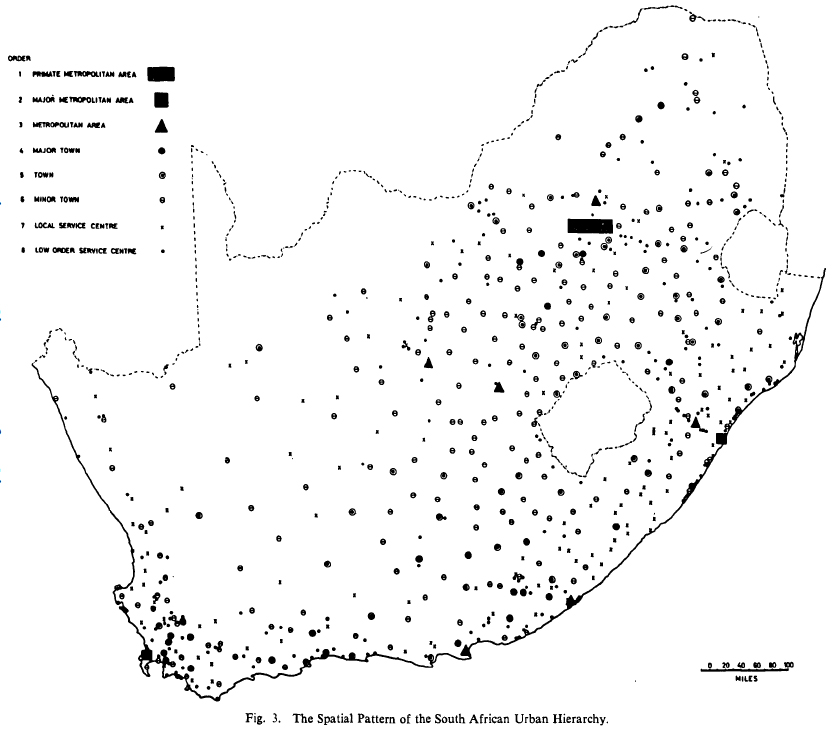
Central places of South Africa (Davies 1967: 16)

In addition, Davies notes that before Americans, Germans have already conducted such research:

“Research thus far has, however, not contributed a central place analysis of South Africa. This paper is concerned with the postulation of an urban hierarchy for the country as the first phase of a more comprehensive study of the detailed functional and spatial inter-relationship of its towns. … The only published central place study of South Africa is one by Carol in 1952 for the Central Karoo region. Carol, H. Das Agrageographische Berachtungssystem. Ein Beitrag zur Landschaftkundlichen Methodik dargelegt am Beispiel der in Südafrika. Geographica Helvetica, 1. (1952), p. 17-67.” (Davies 1967: 9, 18)

Since central place theory was developed in the end of the 1920s and early 1930s, Germans or other Europeans might have done some important research on African territories before the Americans did. But I have no knowledge of this yet. Nevertheless, colonial powers such as the British and the French were not much into this research, while location theories and central place theory mostly originated from German authors.

Hans Carol’s (1915-1971) article is a thrilling and very dense piece. Carol was actually a Swiss geographer working in Zürich, who later moved to York University (Toronto, Canada) in 1962 (see records). His study presents a full geographical account of the Karoo region in Hettnerian fashion, while also applying the new and modern methods of central place theory, which was far from common in geographical studies in the Europe. Apart from using Christaller and Bobek, it cites relevant studies from contemporary British authors who also adapted Christaller’s ideas (Smailes 1946; Dickinson 1947), and even refers to American geography (R. Hartshorne), but does not cite very recent American research (e.g. Ullman 1941), which was still immature, distant and peripheral from the European centre at that time. His first big study was on the area around Zürich, and he used this experience to do an analysis of the functional spatial structure of the Karoo region in South Africa. I think this whole story is a very good example of why we need to look at the entangled histories of how knowledge is made and legitimated through global or transnational connections.

carol_1952_sud_afrika.jpg

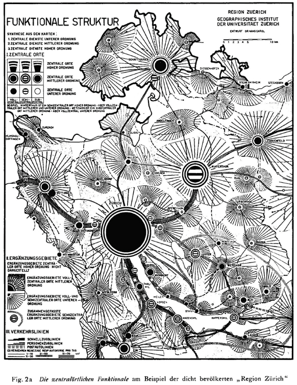
The central places in the region of Zürich (Carol 1952: 30)

carol_1952_sud_afrika_karru.jpg

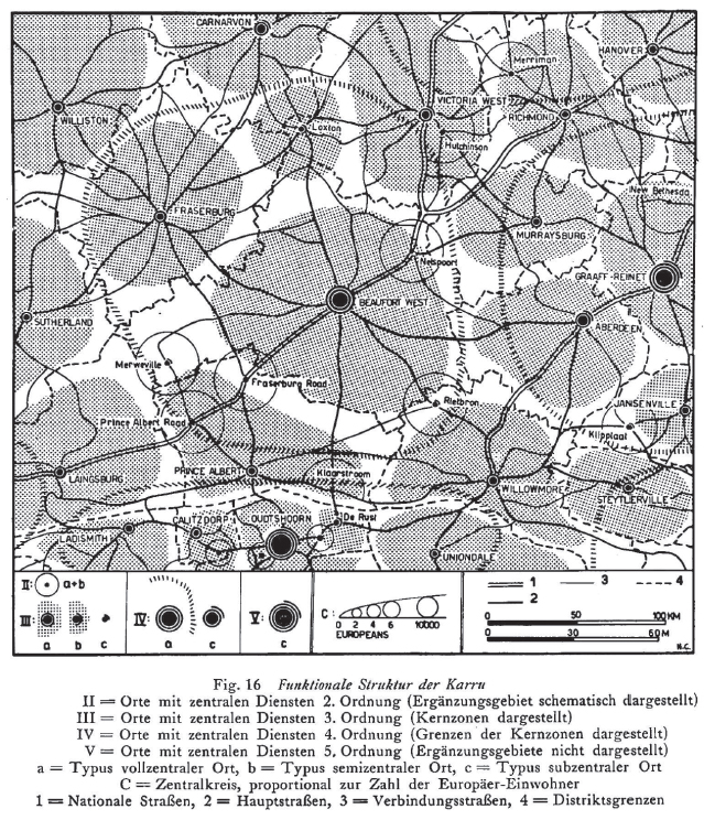
The central places of the Karoo region in South Africa (Carol 1952: 60)

Davies, R. J. (1967): The South African Urban Hierarchy. South African Geographical Journal, 49(1): 9-20.
Dickinson, R. E. (1947): City, region and regionalism. A geographical contribution to human ecology. London.
Nóvé Béla (2001): Interview with László Huszár (1932-2007). Record No. 748. Oral History Archives, Budapest.
Rushton, Gerard (2006): Institutions and Cultures. In : Stuart Aitken and Gill Valentine (eds.): Approaches to Human Geography. SAGE. pp. 171-177.
Smailes, A. E. (1946): The urban mesh of England and Wales. The Institute of British Geographers, transactions and papers, 5. 85—101.
Ullman, E. (1941): A Theory of Location for Cities. American Journal of Sociology, 46(6), 853-864.


The European Regional Conference of the International Geographical Union in Budapest (1971)

In my research, I am gathering all important international conferences and meetings attended by Hungarian geographers and spatial planners in the socialist era. One of the main networks between East and West were the International Geographical Union’s world congresses. The first of these world congresses, where the USSR and Eastern European members attended was the one in 1960 in Stockholm. This showed the post-Stalin era’s softening of isolationist politics and geopolitical tensions, and the world economy’s “boom era” from the end of the 1950s and throughout the 1960s. Urban and regional planning thus came to the fore, with specialists in planning establishing more and more professional connections internationally. But for Hungarian geographers and regional planners, and probably much for East and West connections, probably the most important of these meeting was the European Regional Conference of the International Geographical Union organized in Hungary in 1971. As the organizers wrote in their report to the journal Geoforum:

“Another important attractive force was the fact that the Budapest conference was the first real East-West meeting in the realm of the geographical sciences; approximately 40% of the participants represented the socialist countries.

The conference had 734 registered and attending members from 34 countries. Several people had themselves registered as “non-participating” members in order to receive the interesting publication material. The largest foreign delegation arrived from the Soviet Union – 114. This was followed by the Federal Republic of Germany – 47, United States – 45, Czechoslovakia – 33, and France – 32. The majority of the participants naturally came from Europe, although all the continents were “present” at our conference.

The conference may play a very significant role in the future development of Hungarian geography and the expansion of our international relations. It happened for the first time that we had the opportunity to give an account of the results of the full scope of Hungarian geographical research projects, because of previoussimilar meetings only a few of our scientists had been able to attend. Many of our young research workers participated for the first time in an international meeting of this kind. They had the opportunity of listening to the excellent lectures of prominent representatives of their professional field and to the reports of the most recent results of research, much of which is still unpublished. ” (Enyedi – Marosi 1972: 86, 88)

The preparations for this conference started in 1969, when the Hungarian Academy of Sciences entrusted the Geographical Research Institute with its organization. It took place between 10-14 August 1971 at the Karl Marx University of Economics, Budapest. As many of these congresses of the time, its main topics – where most of the papers were coming in – were urbanization and regional planning. This conference was part of the enormous effort of György Enyedi in establishing Hungarian geography’s international relations, and from the 1970s, Hungarian geographers came much more in the perception of the West.

I have just excavated the conference book of abstracts, so I’m doing a short analysis on this (Lackó – Piroska 1971).

György Enyedi, Sándor Marosi (1972):European Regional Conference of the International Geographical Union. Geoforum, 9: 85-88.
Lackó László, Polyánszky Piroska (1971): International Geographical Union European Regional Conference, Hungary, 1971: Abstracts of Papers – Supplement. MTA KESZ, Budapest.

Contribution of Arab geography to European “discoveries”

“Finally, maritime geography was the last kind discovered during the Ottoman Empire simultaneously with European “geography discoveries.” Columbus’ journey to the New World was motivated by Arab maritime geography. Vasco da Gama used Arab cartography during his journey to Africa and guided by Mal’im Cana. Marco Polo’s journey was guided by Arab sailors. Portolans, Rahnamjats were used by Europeans sailors. Oceanography was founded by Arab maritime geographers and continued on by European modern geographers. The spirit of Muslim Spain was reincarnated in the new Portugese and Spanish Christian geographers and Sailors.”

Contributions of Arab geographers.

List of Muslim geographers.

Islamic cartography.

Hanafi, Hassan (1992): World-views of Arab Geographers. GeoJournal, 26(2): 153-156.

Az ideológiai ellenállás leküzdése mindkét oldalon

Sose fogom elfelejteni azt az esetet, amikor az input-output táblát először hasznosítottuk Magyarországon. 1959. január elsejére a termelői árak radikális reformját készítették elő. Az árrendezés előzetes mérlege – az új áron számított 1959. évi nemzeti jövedelem – 1958 végén 13 milliárd forint hiányt mutatott. Ez akkor horribilis összeg volt, megközelítette a nemzeti jövedelem tíz százalékát, és úgy tűnt, súlyosan veszélybe került a következő évi pénzügyi egyensúly. (A magyarázat világos volt, de fülön csíphetetlen: a minisztériumok és nagyvállalatok kivétel nélkül „túlbecsülték” az anyagköltség árindexét, és „alulbecsülték” saját termékeik árindexeit – a „becslési hiba” kényelmes nyereségtartalékokat biztosíthatott volna számukra a következő évekre.) A Tervhivatal pénzügyi főosztályának vezetője díjat tűzött ki: minden megtalált milliárdért egy üveg pezsgőt. A hiányvadászat hetekig folyt lelkesen, de eredménytelenül.

Végül, hosszas rábeszélés után, nyögve-nyelve, a vezetés hozzájárult ahhoz, hogy az átárazás alapjául készüljön egy viszonylag nagyméretű ágazati kapcsolati mérleg. Ez szokatlan, idegen volt a hagyományos tervezési gyakorlatban, mégis elrendelték a „sakkozást”. (Az ágazatközi mérleget akkoriban sakktáblamérlegnek is nevezték, a sokféle magyarítási kísérlet egyikeként.) Mátrixelemről mátrixelemre, a kibocsátó és a felhasználó ágazatot képviselő tervezők kénytelenek voltak egy asztalhoz ülni, és megegyezni előbb a szóban forgó áramlás terjedelméről régi áron, azután pedig a mindkét oldalon alkalmazandó árindexről. Egy héten belül megkerült mind a 13 milliárd forint. Később, amikor már mindenki kialudta magát, persze összegyűltünk ünnepelni. Irodalmi vénával megáldott kollégáink a helyszínen felolvasott balladákban és drámatöredékekben örökítették meg a „sakkozás” nevezetesebb eseményeit és szereplőit; megittuk a 13 üveg pezsgőt, és még sokkal többet; nagyszerű buli volt.

 …

Az ideológiai ellenállást is le kellett küzdeni, mindkét oldalon. Nyugaton az input-output modell filozófiája és alkalmazása mögött sokan valamiféle burkolt kommunista összeesküvést gyanítottak. Keleten a matematikai módszerek közgazdasági alkalmazása a legjobb esetben is revizionizmusnak számított, a burzsoá métely terjesztésének. Az ideológiának azonban vissza kellett vonulnia. Adott volt a szükséglet, adott volt a szükségletet kielégítő modell, és adott volt a modellt megoldani képes gép. Az input-output modell jött, látták és győzött; meghódította a világot Washingtontól Delhiig, Oslótól Kairóig, Párizstól Moszkváig.” (315-317)

Augusztinovics Mária (1996): Miről szól az input-output modell? Közgazdasági Szemle, XLIII. évf., 1996. április, 315-320.

Kőszegfalvi György: Regionális tervezés (1982)

648607Kőszegfalvi György könyvében Christaller neve, vagy a telephelyelméletek elméleti tárgyalása egyáltalán nem kerül elő (legfeljebb homályos utalásokban). A szöveg hivatkozások nélküli, inkább “tervhivatalos” bürokratikus nyelvezetben íródott, és a gyakorlati alkalmazásra, a magyar esetekre fókuszál. Nagy előnye viszont, hogy a regionális tervezés történelmi kialakulásának és eseteinek nemzetközi áttekintését adja, ami nagyon informatív. Külön érdekes a “Regionális tudomány, térgazdaságtan” című, rövid fejezete, ami ugyanakkor nagyon vázlatos. Kiemeli az amerikai Walter Isard szerepét a regionális tudomány megalapozásában, illetve a szovjet Nyikolaj Nyekraszovot iskolateremtő tevékenységét is említi (az ő regionális tudományról szóló, 1976-os könyvét 1978-ban fordították magyarra). Az amerikai és a szovjet “regionális tudomány” kapcsolatáról és alapvető különbségeiről azonban nem esik szó, ami tudományföldrajzilag azért jelentős, mert elfedi a regionális tudomány alapvetően amerikai jellegét és szovjet kritikáját.

Kőszegfalvi meghatározásában a regionális tudomány “a területi-regionális társadalmi-gazdasági fejlődés” és a “termelőerők területi elhelyezkedésének” tanulmányozásával foglalkozik. Érdekes módon – meglehetősen részrehajlóan – alapvetően csak azokat az aspektusait említi, amivel ő maga és a kötet foglalkozik, tehát az urbanizáció, a településhálózat és az infrastruktúra fejlesztése, az ökológiai tervezés, és kihagyja a regionális tudomány ipartelepítéshez és vállalatok tervezéshez kapcsolódó, talán legfontosabb tevékenységét. Szintén izgalmas szempont, hogy megemlíti a “térgazdaságtant,” amely kb. az 1960-as évek végétől “fejlődött önálló tudománnyá” a regionális tudományokból (többesszám?), miközben nem derül ki, miben is különbözik a regionális tudománytól. Annyit ír csupán, hogy a térrel foglalkozik a gazdaságtudományok szemszögéből.

Berey Katalin: Regionális tervezés – Regionális politika (1996)

Berey rövidke és (rendkívül) vázlatos egyetemi jegyzete már a rendszerváltás utáni nyelvezetet és kánont tartalmazza. Mivel a BME-hez kötődik, ezért elsősorban a szocialista időszakban kialakuló “urbanista lobbi” szemléletét és eredményeit tükrözi, így a településhálózat-fejlesztést és az 1971-es OTK-t részletesen tárgyalja, míg például az ipartelepítést és a gazdasági körzetesítési törekvéseket nem. A szemlélete teljesen folytonos a megelőző időszak “technokratizmusával”, ami tisztán tetten érhető abban, hogy a régiót kizárólag adminisztratív és funkcionális jellege szerint definiálja, természetesen már az EU-s NUTS rendszernek alárendelve.

A jegyzet tipikusan a piacgazdasági átmenet liberális narratíváját követi és az “EU-sodás” során megjelenő szakértőiség feltételeinek megteremtéséről szól. Az egyik fejezet (7.4) konkrétan a “Területi tervezés az átmenet éveiben” címet viseli, ami az 1985-1990 közötti, meglehetősen önkényesen lehatárolt időszakról szól.

“Az európai integrációs folyamatokhoz csatlakozás a területi tervezéstől elvárja az európai tervezési rendszerek megismerését, tapasztalatainak a magyar viszonyokra adaptálását, a területi és információs egységet biztosító kommunikációs infrastruktúra fejlesztését, továbbá a gazdasági és területi innovációt.” (10)

Regionális tervezés, regionális tudomány

Szintén posztszocialista vonás, hogy a regionális tervezés alkalmazott, szakpolitikai területe mellett tudományos területként már a regionális tudományt nevezi meg. Ugyanakkor ezt érdekes módon – és ez egy nagyon alapvető hiba – a regionális földrajzhoz is köti. Például:

“A regionális földrajzi gondolkodás fejődésében korszakteremtő W. Isard munkássága, akinek a nevéhez az új tudományos diszciplínának tekinthető komplex “regionális tudomány” (regional science) megalkotása fűződik.” (17)

Az pedig igen különös állítás (vagyis hamis és történelmietlen), hogy

“A regionális tudományok egyik elméleti gyökere, a modern tájelmélet már a XIX. század végén megjelenik.” (17)

A regionális tudománynak (egyes szám) semmi köze nincsen az ún “modern tájelmélet” nevezető konstrukcióhoz (akármit is jelentsen ez).

A jegyzet említi a gravitációs modelleket, és ír a “centrum-periféria” viszonyrendszerről is, habár ez utóbbiról semmilyen konkrét elmélet nem kerül elő: pl. kiemeli, hogy aszimmetriát és hierarchikus viszonyt jelent, de hogy ezt hogyan kell értelmezni, vagy miért van így, arról semmi nem derül ki. Márpedig ez egyáltalán nem mindegy. Ugyanakkor egészen furcsa és értelmezhetetlen történelmi állításokat fogalmaz meg:

“…a perifériák kizsákmányolásán alapul, amely legszélsőségesebb formájában a “vad”kapitalizmus, vagy a korai iparosítás korszakában érvényesül. Ebben az időszakban érhető tetten a hierarchikus településrendszer “fejlődése”, a különböző típusú perifériák kitermelődése, területi terjeszkedése, helyzetének kritikussá válása, végül a csődje.” (24)

“A centrum-pefiéria helyzet történetileg nem alakított ki egyensúlyt, ez a folyamat nem vezetett olyan stabil, kölcsönösségen alapuló helyzet kialakulásához, mint a középkori vásárvárosok és a környező falvak esetében, ahol a “központi hely” a periféria, a környék számára is létfontosságú s kettőjük funkciói kölcsönösen kiteljesítik egymást.” (24)

Megemlíti a (gazdasági) körzetelméleteket, de kizárólag a szovjet rajonírozás adaptálását:

“A körzetelmélet már a XIX. század fordulóján megfogalmazódott Franciaországban, azonban csak a központosított tervgazdálkodást folytató országokban vált meghatározóvá, amelyekben a központi tervek egyik alapeleme, meghatározó kerete volt. Az országos ötéves, távlati és más terveket rendszerint “lebontották” a tervezési-gazdasági körzetek (rajonok) regionális léptékére. Így volt ez a szovjet területi és gazdasági tervezési rendszerben, így volt a legtöbb kelet-európai országban. … A rajonok körülhatárolásával kapcsolatos elméletek a körzetelmélet adaptációi, ezt töltötte fel a központosított tervgazdaság új, ideológiai és politikai tartalommal.” (21)

A posztszocialista időszakra rögzülő magyar kánon jelenlétét jól mutatja, hogy az urbanizáció kapcsán csak Erdei Ferenc és Enyedi György elképzeléseiről ír, és az univerzalitás bűvöletében vázolja fel az Enyedi által gyakorlatilag csak felületesen átvett “városfejlődési ciklusokról”, amely kizárólag amerikai és bizonyos nyugat-európai tapasztalatokra épül. Lényegében ez helyettesíti a nemzetközi szakirodalmat és tapasztalatokat, ami enyhén szólva csúsztatás és elhallgatás. Ez azért is veszélyes és értelmetlen, mert a magyar városfejlődés nyilvánvalóan egészen más módon alakult, mint az evolucionista városnövekedés vagy városciklus-elméletből következne, de ezt a kötet a magyar városfejlődési viszonyok taglalásakor nem egyezteti.

Christaller központi helyek elmélete

Berey jegyzetének érdekessége, hogy a regionális tervezés elméleti alapjának abszolút főszereplője Walter Christaller központi helyek elmélete. Míg a szocialista időszakban szinte egyáltalán nem, a mai releváns szakirodalomban pedig csak keveset írnak arról, hogy az 1960-as évek településhálózat-fejlesztési koncepcióinak fő elméleti bázisa Christaller munkássága révén a matematikai alapon számítható ellátási körzetek voltak.

Erről a magyarországi adaptációról nagyon feltáróan, de alapvetően negatívan ír:

“Az ellátás fogalmát azonban részben a Christaller-féle “központi” hely elméletéből, részben az energia, a közlekedés látszólag csekély költségeiből kiindulva úgy értelmezte, hogy a “központban” rendelkezésre álló intézmény a körzetében élő lakosság számára is magától értetődően hozzáférhető, tehát egyszerűbb a lakosságot az intézményekhez utaztatni, mint az intézményellátást a lakóhelyen fejleszteni. A magyarországi településhálózat azonban nem felelt meg a Christaller-féle sémának. Az Alföld óriásfalvai túl nagyok, az aprófalvak hálózata túlságosan elaprózott volt, nem beszélve arról, hogy az ország jelentős részén “városhiányos” volt a térség, azaz, a Christaller-sémának megfelelő “központi hely” nem is létezett.” (62)

Az elmélet eredetéről és nemzetközi alkalmazásáról pedig a következőket írja:

“W. Christaller elméletét a harmincas évek Dél-Németországa példájával igazolta, ahol egy agrár típusú régió meghatározott települési viszonyai érvényesültek. Az elmélet kritikusai azt vonták kétségbe, hogy másmilyen földrajzi és társadalmi viszonyok között is érvényes ez a modell, és feltették a kérdést, egyáltalán megállja-e a helyét az a feltételezés, hogy a településhálózat zárt rendszer, ahol csak a belső mozgások törvényszerűségei érvényesülnek.

A központi helyek elméletét a központosított tervgazdálkodást folytató országok is használhatónak találták. Például jelentős szerepet kapott a hitleri Németország állami reorganizációs törekvéseiben, de a kelet-európai államszocialista rendszerek “településhálózati koncepciói” is számos vonásban visszavezethetők a központi helyek elméletére, főként, ami a különböző szintű “ellátási körzeteket” és az ehhez kapcsolódó intézményhálózat fejlesztési programokat illeti.” (23)

Érdekes, hogy csak a náci sztorit említi meg, míg más fontos alkalmazásokat nem. Az a meghatározó tudásföldrajzi kontextus sem derül ki, hogy a központi helyek elméletét főleg az amerikaiak és részben a britek fogják fejlesztették fel és terjesztették (vagyis tőlük vették át). Nagyon pozitív és fontos viszont, hogy a jegyzetben megjelenik a “zárt rendszer” problémának a gondolata (habár ennek politikai és ideológiai vonatkozásaira nem derül fény), illetve a “modell” alkalmazhatóságának földrajzi problémája.

A két rendszer közeledése és a technokrácia hatalma

“…a kapitalizmus és a kommunizmus közötti hosszú ideológiai küzdelemben tanúi lehettünk annak, hogy az eszmék kölcsönösen befolyásolták egymást … az együttélésből napjainkban szintézis lett … korunk technokráciája. A huszadik század második felének bürokratikus struktúrájában fejeződtek és fejlődtek ki a két rendszer közös jellemzői. A technokratákban, akik az állami vállalatokat vezetik a Szovjetunióban és a magánvállalatokat az Egyesült Államokban, sokkal több a közös vonás, mint ahogy sokan feltételezik. Mindketten a modern technika szülöttei. Tevékenységüket a termelési és fogyasztási statisztikák irányítják. Mindketten a bruttó nemzeti termék növekedési számainak fanatikusai … Ami pedig a legfontosabb, mindketten hasonló módon reagálnak egy sor kérdésre, a pénzügyiekre, a termelékenység ösztönzőire, a fogyasztás serkentésére vagy korlátozására, az expanziót és a fejlődést célzó beruházásokra.”

A. L. Camargo volt kolumbiai elnök beszédéből a “Kapitalizmus jövője” c. tanácskozáson New Yorkban, 1966 szeptemberében (idézte Simai 1969: 5).

“A konvergenciaelmélet hirdetőinek érvei között gyakori az is, hogy a szocializmusban a hatalom egyre inkább a technokraták kezébe kerül, akik lényegében véve ugyanúgy gondolkodnak és döntenek, mint kapitalizmusbeli “kollégáik”. … A Szovjetunióban és a legtöbb népi demokratikus országban azonban viszonylag kevés ilyen szakember volt a szocialista fejlődés kezdetén, és általában alacsony volt a széles néprétegek kulturális színvonala is. … A szocialista építés során egyesek nem tudtak megfelelni közülük a rájuk bízott feladatnak. Mások azonban a gyakorlat iskolájában értek vezetőkké. Gyakran ez valamilyen iskola, egyetem elvégzésével is párosult. Sokan közülük diplomás mérnökökké, közgazdászokká, agronómusokká váltak, tehát a nyugati szakemberek megfogalmazása szerint “technokratákká”. Egyre nagyobb mértékben került az új rendszerben felnőtt és a kulturális forradalomban tömegesen kiképzett fiatal gárda is a vezetésbe. Ez a folyamat elkerülhetetlen. Hiszen 20-30 évvel a szocialista átalakulás után a vezetés egyre bonyolultabb feladatokkal találja magát szemben. Nemcsak a termelés technikai feltételei válnak lényegesen összetettebbé, hanem a társadalmiak is.

A szocialista társadalomban végbemenő és a kapitalizmusnál gyorsabb átalakulás nyomán nőnek a társadalmi-politikai vezetőkkel szemben támasztott követelmények is. A magasabb kulturális szinten álló tömegek nagyobb igényeket támasztanak az ideológiai, politikai, kulturális élettel csakúgy, mint a vezetési stílussal szemben. … A vezetők szakképzettségének emelkedése, a szakképzett vezetők általánossá válása az európai szocialista országokban táplálja a “technokraták hatalmáról” született nézeteket.

A technokrata a köztudatban olyan személy, aki csak a technika szükségleteiből indul ki. Figyelmen kívül hagyja a társadalmi, politikai, tehát az “emberi” összefüggéseket. Vitathatatlan, hogy ennek veszélye egyes konkrét döntések esetében a szocialista társadalomban is létezik, különösen a fejlődés jelenlegi szakaszában, a korábbi szubjektív, a technikai fejlődéssel, a termelőerők hatékony kihasználásának igényeivel nem kellően számoló gazdasági vezetési módszerekkel szembeni reakcióként.

A szocialista társadalom továbbfejlesztésének objektív érdekei és szükségletei, amelyek az emberek tudatos cselekvésén keresztül érvényesülnek, a szocializmusban végső soron útjában állnak az olyan törekvéseknek, hogy csupán a technikai fejlődés követelményei váljanak a gazdasági döntések mozgatóivá. A marxista-leninista pártok egyik döntő feladata a szocialista társadalom általános érdekeivel ellentétes antihumanista döntések megakadályozása, és az ember teljes felszabadulása irányába való sokoldalú fejlődés előmozdítása a szocialista társadalom ellenőrző erejének érvényesítése.

A szakértelem növekedése a döntésekben és a vezetők magasabb szakmai szintje nem jelenti a “technokraták hatalmát”. Nemcsak hogy nem lehet a két rendszer “konvergenciájának” jele vagy forrása, hanem ez a szocialista viszonyok továbbfejlesztésének egyik döntő feltétele.” (43-46)

Simai Mihály (1969): Közeledik-e a két rendszer egymáshoz? A konvergenciaelméletről. Kossuth Könyvkiadó, Budapest.

Debating geographical determinism in the seminars of professor Sárfalvi

English

“Even the fact, that the the place of seminars were substituted from rigid classrooms to professor Sárfalvi’s own room crammed full of books, changed the environment, and it was unusual that the “classes” gave floor to heated debates; I remember, for example, that many of us really sided with the anti-Marxist Huntington and Teleki in the issue of determinism, and this could be openly argued for. (Tried if we would the same in the infamous scientific socialism seminars…)”

These rememberings are really interesting, since on the one hand they show contemporary reading experiences, and the other, the “counter-discourses” in the socialist era university environment, and the kind of knowledge used to construct a(n alternative) geographer identity.

Hungarian

“Már maga a tény, hogy a rideg tanterem helyett Sárfalvi tanár úr könyvektől roskadozó szobájában folytak a szemináriumok, oldottabbá tette a hangulatot, és szokatlan volt, hogy az “órákon” parázs viták is folytak; emlékszem pl., hogy többen igencsak az antimarxista Huntington és Teleki pártján álltunk a determinizmus kérdését illetően, és ezt ott bátran ki lehetett fejteni. (Próbáltuk volna ugyanezt a híres-neves tud. szoc. szemináriumokon…).”

(Horváth Gergely: Az európaiság gondolatának tükröztetése a földrajztanár-képzésben. In: Probáld Ferenc (szerk.): Pro Geographia Humana. ELTE Eötvös Kiadó. p. 90.)

Nagyon érdekesek ezek a visszaemlékezések, hiszen egyfelől rávilágítanak a korabeli olvasmányélményekre, másfelől a szocialista egyetemi környezetben megjelenő “ellendiskurzusokra,” azaz hogy milyen tudáshoz kapcsolódóan alakítottak ki “ellenzéki” földrajzos identitást a hallgatók.

Egyébként pedig Ellsworth Huntingtonról van szó, aki az amerikai eugenika és fajegészségügy egyik oszlopos tagjaként és a Yale egyetem professzoraként az amerikai bevándorláspolitikára is nagy hatással volt. Támogatta többek között a korabeli elitista oktatáspolitikát, a fogyatékkal élők és alacsony IQ-jú emberek sterilizálását (ennek több tízezer ember esett áldozatul). Elméleteiben a faji kiválasztódás , illetve az éghajlati energiáknak a civilizációk vagy fajok fejlődésére vonatkozó hatásai mellett érvelt, a “néger”, “ázsiai”, és bizonyos európai (pl. magyar) népeket alacsonyabb rendűnek tartotta a nyugati, elsősorban angolszász népeknél. Az 1930-as évek végére az amerikai geográfusok nagy része igyekezett háttérbe szorítani nézeteit.