Plotting the Semiperipheral Empire: Hungarian Balkanism and Global Colonialism in Geographical Knowledge, 1867–1948

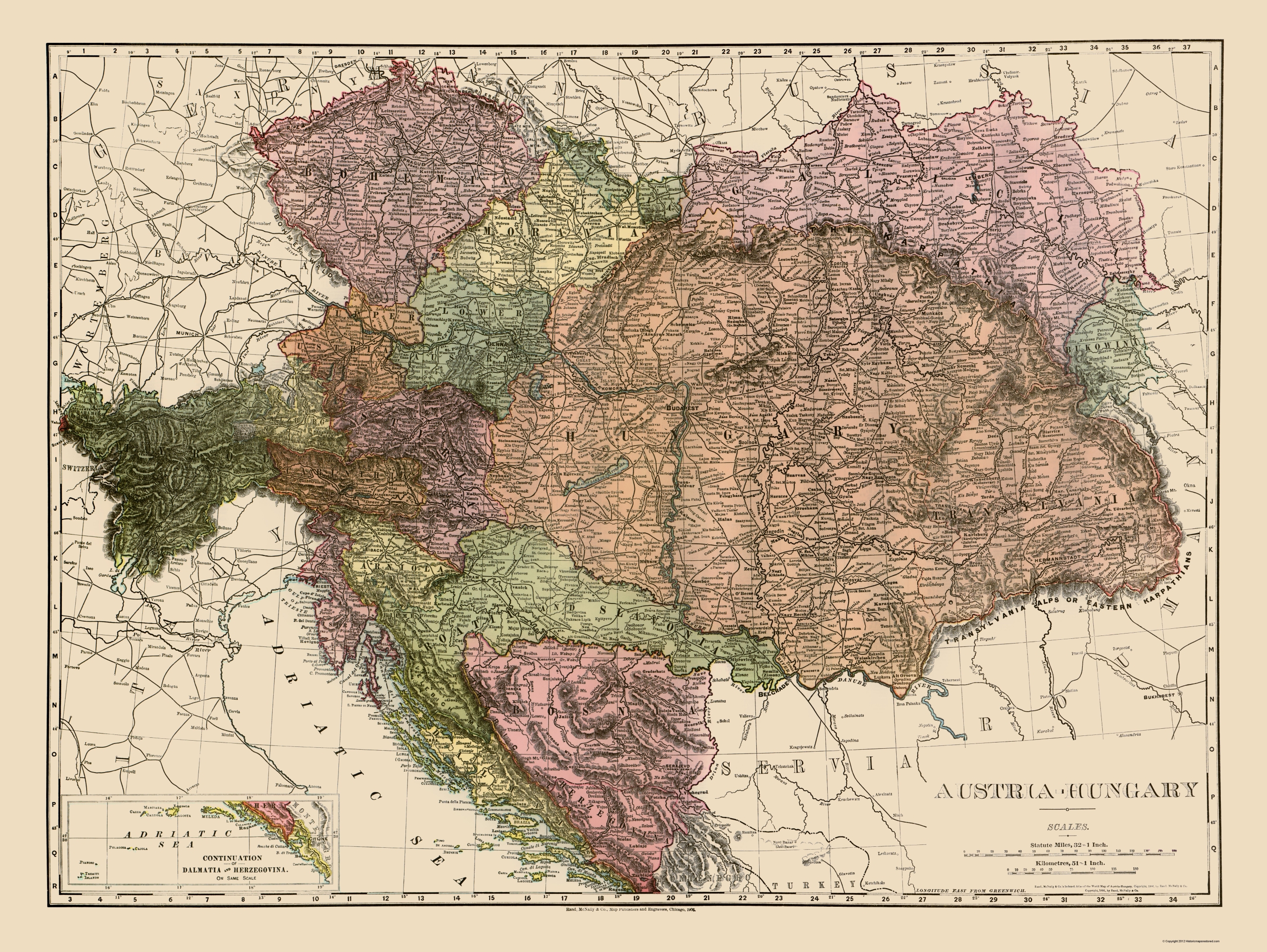
austria-hungary map

43rd Annual Conference on the Political Economy of the World-System

Albert-Ludwigs-University of Freiburg, Germany

Topic: 2. The Balkans’ inter-imperial linkages

Eastern Europe is the “black sheep” of postcolonial studies: its colonial experiences have been routinely missed out from the relentless focus on (post)colonial centres and peripheries. Since the 1990s, postcolonial literature has extended Orientalism to the Western construction of Eastern Europe and the Balkans, and has reinterpreted colonial relations with regards to Soviet imperialism, the postsocialist transition, the European integration, and Eastern Europe’s role in decolonization and socialist globalization. However, due to dominant historical narratives, the imperialist or colonialist ambitions of Eastern or East Central Europe seem to go against the grain, since these countries were often colonized, rarely or never held any colonies, and did not have any significant colonial ambitions.

This contradiction may be resolved by revising the restrictive Western-Atlantic narrative of global history and the territorial understanding of colonialism, and look into the various ways colonialism and imperialism were spatially practiced and geographically imagined in Hungary. Hungarian geographical knowledge production from the mid-19th to the mid-20th centuries related to the Balkans is a demonstrative case study of semiperipheral imperialism. Hungarian imperialist ambitions grew from the economic boom in the late 19th century and Austro-Hungarian geopolitical interests to secure southern areas against Russia, Turkey and Serbia. Although the tragic defeat in WWI led to the Hapsburg Empire’s demise, huge Hungarian territorial losses and defensive revisionism, these only replenished arguments for Hungarian civilizational superiority in the region.

Hungary’s semiperipheral “in-between” position constructed a complex and ambivalent imperialist-nationalist discourse on various intertwined scales. On the global scale, Hungary was imagined as part of an Empire and the superior white race and civilization. The country was an active observer, participant, and benefiter of “high imperialism”, and Hungarian Balkanism was both deeply intertwined with and a semiperipheral compensation to global colonialism. Standing at both a global civilizational fault line and exchange border, Hungary’s “turn to the East” represented a geopolitical rhetoric of developing Orientalism, approaching the post-Ottoman Balkans, and searching for the Hungarian homeland in Central Asia as an attempt at East-West maneuvering and cultural imperialism in the Asian continent. On the European scale, Hungary countered (mostly) German and Austrian hegemony and Western Europe, but also expanded national hegemony by upholding the merits of European civilization against the half-European periphery and the non-European world, acting as the “lord protector” of Christian Europe against the Muslim East. On the regional scale, the Carpathian Basin became the stage of a Hungarian “civilizing mission” towards culturally backward and “half-Europeanized” landscapes, in order to both bring and protect European civilization by upholding a “bridge” role and an essential “healthy mix” of Eastern and Western traits. The ideal nation-bearing hearthland landscape of the Alföld basin was geographically co-constructed in relation to the Balkan “Other”, while imperialist visions of cultural and economic expansion were naturalized by transforming the “wild” Karst and opening to “the Hungarian sea”. The Balkans offered a gateway to sovereign Hungarian development by de-linking from Western dependency and maturing as a true European nation by linking through active maritime participation to the global colonial world.

See an earlier version of this project here.

© Copyright – Content is protected by copyright!

Ginelli, Z. (2019): Plotting the Semiperipheral Empire: Hungarian Balkanism and Global Colonialism in Geographical Knowledge, 1867–1948. Critical Geographies Blog, 2019.03.18. Link: /2019/03/18/plotting-the-semiperipheral-empire-hungarian-balkanism-and-global-colonialism-in-geographical-knowledge-1867-1948

Új blogsorozat: Magyarország és a gyarmati világ / New blog series: Hungary and the colonial world

A bevett olvasat szerint nekünk soha nem voltak gyarmataink, sosem vettünk részt a gyarmatosításban, ezért semmi közünk nincsen a (poszt)gyarmati világhoz. De valóban így lenne? Új blogsorozatom ezt a témát igyekszik körüljárni! Hogyan kapcsolódott Magyarország a gyarmatosításhoz, a gyarmatbirodalmi rendszerhez és a gyarmati diskurzushoz? Milyen módokon fogalmazták meg a gyarmatiság kérdését és problémáját magyar tudósok, írók és politikusok? Hogyan termelték, mutatták be és hogyan fogyasztotta a magyar közönség a kolonializmusról és a gyarmati világról szóló földrajzi tudást? Hányféleképpen értelmezhetjük a gyarmat és a gyarmatosítás fogalmait magyar és kelet(közép-)európai szempontból? Vajon hogyan tekinthetünk a magyar történelemre és társadalomra másképpen a gyarmati viszonyok vizsgálata szempontjából? A bejegyzések a magyar földrajzi tudástermelés (poszt)koloniális viszonyait feltáró kutatásaimat követik kritikai geográfus szemmel, várhatóan magyar és angol nyelvű olvasók számára is!

Kövessed és oszd meg a bejegyzéseket Facebookon a Magyar Kritikai Geográfusok Fórumán!


– ENGLISH VERSION –

According to the dominant narrative, we Hungarians never had colonies, we never participated in colonization, and so we have nothing to do with the (post)colonial world. But is this so? My new blog series aims to cover this topic! How did Hungary relate to colonization, the imperial colonialist system, and colonial discourse? In what ways was the colonial question problematized and discussed by Hungarian scholars, writers and politicians? How was geographical knowledge about colonialism and the colonial world produced, presented and consumed by the Hungarian public? How can we conceptualize the terms colony and colonialism from a Hungarian and Eastern (Central) European perspective? In what multiple ways can we understand Hungarian history and society differently in light of colonial relations? The blog posts will follow my research on the (post)colonial relations of Hungarian geographical knowledge production from a critical geographical view, hopefully coming to both Hungarian and English readers!

Check out and share the posts on Facebook on the Forum for Hungarian Critical Geographers!

Tracing the Global History of the Quantitative Revolution: The Transnational History of Central Place Theory

christaller_cpt2

Zoltán Ginelli

Book Plan

The quantitative revolution has been an epochal textbook chapter in geography’s canonical history, marking a time when the discipline transformed into a rigorous social science backed by predictive mathematical methods in the early Cold War. An iconic scientific concept of this quantitative movement, most notably related to Walter Christaller (1933) and August Lösch (1939), was central place theory (CPT), which postulated a triangular-hexagonal structure of hierarchical settlement systems based on marginalist economics and behaviourist assumptions. It was a foundational theory for the emerging field of spatial analysis, including regional science (Isard, 1956) and regional or urban economics. With the intensive globalization of the quantitative revolution after its emergence from the Second World War in the United States (Barnes and Farish 2006), location theories such as CPT became very influential and widespread in urban and regional planning across the entire world. But in the West, vigorous efforts to criticise spatial science from the 1970s onwards (e.g. Gregory, 1978) developed a revisionist narrative that stressed the influence of positivism, rationalism, technocratism, and Cold War American hegemony. This ultimately added to the already reduced view of actual historical events (Livingstone, 1992; cf. Van Meeteren, forthcoming), while recent research has only begun to unravel the variegated geographical contexts of the quantitative revolution (e.g. Barnes, 2003). Reflecting on its initial North American centres, Barnes (2002, 508) passingly remarked: “Why are places in Africa not on there, or Asia, or Australasia?” Following Barnes’s plea for a more wider interpretation, we attempt to pose a number of questions. How did quantitative spatial analysis and planning develop in different parts of the world? In what different geographical contexts were location theories like CPT read, reinterpreted, applied, and mobilized? How were these often very different contexts connected?

This book offers to fill this significant gap in geography’s twentieth century global history by following a transnational framework based on the historical geographies of scientific knowledge (Livingstone, 2003; Withers, 2007). It aims to deconstruct the mainstream Anglo-American narrative by tracing the quantitative revolution through the circulation and local applications of CPT in the “Second” and “Third” worlds and also into the pre-Cold War era (Ginelli 2018; Ginelli, in preparation). CPT was abstracted and canonized pragmatically by American-led spatial science despite originating from a much wider and more complex European interwar discourse than commonly appreciated (Radeff, 2012; Van Meeteren and Poorthuis, 2018). Antecedents reached into late 18th and 19th century ideas by German, French, and Swiss political economists, engineers, mathematicians, and geographers (Istel, 2002), and the so-called Garden City Movement across Europe (Fehl, 1992). The discussion of location theories grew rapidly in interwar Europe, as the Great Depression (192933) and world economic crisis ignited state-led interventionism and technocratism, which was embedded in a transnational discourse of rationalizing reforms by emerging administration science and regional planning, the application of functionalist and modernist ideas, Fordist-Taylorist development, mathematical economics, and long-term planning that disregarded ideological barriers. During the Second World War, CPT was intensively applied by Christaller under the “reactionary modernist” Nazi regime to plan the colonization and German resettlement of Poland by the Third Reich (Generalplan Ost) (e.g. Rössler, 1989; Preston, 2009; Barnes and Minca, 2013). Notable early applications included Estonia (Kant, 1935), the Nordoostpolder settlements in the Netherlands in the 1940s (Bosma 1993), the new settlements of expanding Israel in the mid-1950s (Trezib, 2014), research and application in regional planning in Britain (e.g. Dickinson, 1942; Smailes, 1944), introduction to the USA (Ullman, 1941; Brush, 1953; Berry & Garrison, 1958), and the regional planning of Sweden (e.g. Godlund, 1951). The yet weak American, British, and Canadian network of the quantitative movement was supported by the Swedish hub in Lund, which was also important in disseminating the application of location theories into Scandinavia and other parts of Europe in the 1960s (Barnes and Abrahamsson, 2017; Van Meeteren, in preparation). The Anglo-American impulse traversed easily into other Anglophone contexts such as Australia and New Zealand (e.g. Duncan 1955), and reached France through Canada in Francophone networks (Cuyala, 2015), while it helped legitimize the German reinvigoration of CPT in the 1960s in face of its wartime burden (Kegler, 2015).

These mostly North Atlantic and Western, Central, and Northern European cases were followed by parallel developments and were increasingly connected into a global network despite Cold War ideological tensions, especially through international organizations such as the International Geographical Union and urban or regional planning organizations. The globalization of CPT under American Cold War hegemony from the early 1960s led to the Americanization of German location theories in an economistic modernization discourse, supported by USAID, United Nations, and World Bank projects. CPT became an important instrument of state-interventionist modernization and urbanization policies in the “planning laboratories” of the Global South, embedded in existing and emerging postcolonial knowledge networks devised by important centres of the quantitative revolution (Ginelli, in preparation). Early applications in India were followed by various others in South East Asia, West Asia (Clark & Costello 1973), and also East Asia (Ullman 1956), such as China (Skinner, 1964) and Japan (Hayashi, 1973). New statistical surveys and development projects made possible mostly American or British initiatives of applying CPT in African countries, such as Ghana (Grove & Huszár, 1964; Gould; McNulty 1969), Nigeria (Mabogunje, 1968), Kenya (Soja, 1968), South Africa (Carol, 1952; Davies, 1967) amongst many others. In South America, development projects in Peru, Chile (Berry, 1969), Colombia, or Bolivia also applied CPT, and the quantitative revolution spread through modernizing regimes as the case of Brazil suggests (Lamego, 2015; 2016). A number of comparative and critical works of applying CPT in the Global South appeared (e.g. Kuklinski 1978). In the socialist world, after the Stalinist purge of internationally renowned mathematical economics during the 1930s and 1950s, there developed a parallel “mathematical thrust” and growing East-West exchange during the détente of the 1960s (Jensen & Karaska, 1969; Saushkin, 1971). Soviet and Eastern Bloc reformism and the institutionalization of urban and regional planning in the mid-1950s summoned CPT in the service of centralized and long-term state planning, which ignited debates of adaptability between “socialist” and “capitalist” contexts, and also between domestic industrial or welfare policies (Ginelli, forthcoming). CPT strongly influenced the national urban and regional planning concepts of Eastern European countries, where it was already well known, Hungary, Yugoslavia, Poland, Czechoslovakia, and Romania (e.g. Perczel & Gerle, 1966; Vrišer, 1971). Apart from diffusing through Comecon plan coordination, socialist planning discourse borrowed from a transnational pool of knowledge. Quite remarkably, the seemingly “neutral” mathematical-geometrical language of CPT and the political demand for national development plans interweaved “socialist” and “capitalist” contexts, which held important continuities into the postsocialist era (Ginelli, forthcoming; in preparation). With the “new economic geography” emerging in the 1990s, the already developed canon of location theories such as CPT were solidified in neoclassical economics and neoliberal policies connected to a new regionalism.

Drawing on a number of such case studies, this book project aims to connect, contest, and contribute to various fields in the history of scientific knowledge. First of all, it explores the global histories of geography, regional science, urban studies, economics, and related fields in a period marked by geopolitical transitions such as the Second World War, decolonization, and the end of the Cold War. Arguing for a global discourse of CPT, this book contests current disciplinary accounts by re-addressing issues of narrativity, historical periodization, and geographical foci. It aims to broaden the fields of intellectual history and the sociology of science by connecting to the approach of science and technology studies to trace the spatial biographies of various actors, including people, ideas, theories, data, practices, technologies, or capital (e.g. Daston 2000). The yet unwritten transnational history of CPT and spatial analysis fits into the burgeoning literature on the transnational histories of Cold War technosciences, such as mathematical economics, statistical analysis, cybernetics, ekistics, systems theory, linear programming, game theory, or diffusion analysis (e.g. Andersson & Rindzeviciute 2015). This book also contributes to the growing studies of architectural history and policy mobilities, and the history of urban and regional planning with the aim to rethink postwar planning history (Ward, 2010; Wakeman 2014). On a further account, the book reveals the uneven power relations in global knowledge production and thereby adds to postcolonial and decolonial studies by decentering dominant Anglo-American knowledge production by focusing on interconnectivity and peripheralized contexts.

References

Andersson, J. & Rindzeviciute, E. (eds.)(2015): The Struggle for the Long-Term in Transnational Science and Politics: Forging the Future. London: Routledge.

Barnes, T. J. (2002): Performing economic geography: two men, two books, and a cast of thousands. Environment and Planning A, 34: 487–512.

Barnes, T. J. & Minca, C. (2012): Nazi Spatial Theory: The Dark Geographies of Carl Schmitt and Walter Christaller. Annals of the Association of American Geographers, 103(3): 669–687.

Barnes, T. J. & Abrahamsson, C. C. (2017): The imprecise wanderings of a precise idea: The travels of spatial analysis. In Jöns, H., Meusburger, P. and Heffernan, M. (eds.): Mobilities of Knowledge. Dordrecht: Springer. 105–121.

Berry, B. J. L. & Garrison, W. L. (1958): The functional bases of the central place hierarchy. Economic Geography,
34(2): 145–154.

Berry, B. J. L. (1969): Relationships between Regional Economic Development and the Urban System: The Case of Chile. Tijdscrift voor Economische en Sociale Geografie, 60: 283–307.

Bosma, K. (1993): Verbindungen zwischen Ost- und Westkolonisation. In: Rössler, M., Schleiermacher, S. (eds.): Der “Generalplan Ost”: Hauptlinien der nationalsozialistischen Planungs- und Vernichtungspolitik. Berlin: Akademie Verlag. 198–214.

Brush, J. E. (1953): The Hierarchy of Central Places in Southwestern Wisconsin. Geographical Review, 43(3): 380-402.

Carol, H. (1952): Das Agrageographische Berachtungssystem. Ein Beitrag zur Landschaftkundlichen Methodik dargelegt am Beispiel der in Südafrika. Geographica Helvetica, 1: 17–67.

Christaller, W. (1933): Die zentralen Orte in Süddeutschland. Jena: Gustav Fischer.

Clark, B. D. & Costello, V. (1973): The Urban System and Social Patterns in Iranian Cities. Transactions of the Institute of British Geographers, 59: 99–128.

Cuyala, S. (2015): Mapping the sources of diffusion and the active movements of scientists by using a
corpus of interviews: An experiment about the origins of theoretical and quantitative geography in French-speaking Europe. Terra Brasilis (Nova Série), 5.

Davies, R. J. (1967): The South African urban hierarchy. South African Geographical Journal, 49(1): 9–20.

Daston, L. (ed.)(2000): The Biographies of Scientific Objects. Chicago & London: The University of Chicago Press.

Dickinson, R. E. (1947): City, Region and Regionalism. London: Meuthen.

Duncan, J. C. (1955): New Zealand Towns as Services Centres. New Zealand Geographer, 11(2): 119–138.

Fehl, G. (1992): The Nazi Garden City. In: S. V. Ward (ed.): The Garden City: Past, Present and Future. Milton Park & New York: Taylor and Francis. 88–106.

Ginelli, Z. (in preparation) The historical geographies of the “quantitative revolution”: Towards a transnational history of central place theory. Ph.D. Dissertation. Budapest: Eötvös Loránd University, Faculty of Science, Doctoral School of Earth Sciences, Geography-Meteorology Program.

Ginelli, Z. (2018, forthcoming): Globalizing the “quantitative revolution”: The “technocratic turn” in geography and spatial planning in socialist Hungary. In: Idem (ed.) Technosciences of Post/socialism.

Ginelli, Z. (2018): Critical Remarks on the “Sovietization” of Hungarian human geography. In:

Godlund, S. (1951): Bus Services, Hinterlands and the Location of Urban Settlements in Sweden, especially in Scania. Lund.

Gregory, D. J. (1978): Ideology, Science and Human Geography. London: Hutchinson & Co.

Grove, D. J. & Huszár, L. I. (1964): The Towns of Ghana. Accra: Ghana Universities Press.

Gunawardena, K. A. (1964): Service centres in southern Ceylon. University of Cambridge, PhD Thesis.

Hayashi, N. (1973): On the Spatial Features of the Central Functions in Tokai Area. The Human Geography, 25: 26-52.

Istel, W. (2002): Zentrale Orte und ihre Einzugsbereiche. Theorien, empirische Untersuchungen, raumordnerische Anwendungen bis 1945. Ein Lese- und Lehrbuch in zwei Teilen. Tl.1. Prae Christaller. Zentrale-Orte-Theorien und empirische Zentralitätsuntersuchungen zwischen 1809 und 1933/34. Entmytholosierung einer Theorie, München : Fachgebiet Raumforschung, Raumordnung u. Landesplanung, Techn. Univ. München.

Jensen, R. G. & Karaska, G. J. (1969): The mathematical thrust in Soviet economic geography: Its nature and significance. Journal of Regional Science, 9: 141–152.

Kant, E. (1935): Bevölkerung und Lebensraum Estlands. Ein Anthropoökologischer Beitrag zur Kunde Baltoskandias. Tartu: Akadeemiline kooperatiiv.

Kegler, K. R. (2015): Deutsche Raumplanung. Das Modell der “Zentralen Orte” zwischen NS-Staat und Bundesrepublik. Paderborn: Ferdinand Schöningh.

Kuklinski, A. (ed.)(1978): Regional Policies in Nigeria, India and Brazil. The Hague: Mouton de Gruyter.

Lamego, M. (2015): Genius loci Duas versões da geografia quantitativa no Brasil. [Genius loci: two versions of quantitative geography in Brazil.] Terra Brasilis (Nova Série), 5: 114.

Lamego, M. (2016): Sobre a geografia da ciência: perspectivas locais e transnacionais nas histórias da geografia quantitativa brasileira. [On the geography of science: local and transnational perspectives in Brazilian quantitative geography]

Livingstone, D. N. (1992): The Geographical Tradition: Episodes in the History of a Contested Enterprise. Malden and Oxford: Wiley-Blackwell.

Livingstone, D. N. (2003): Putting Science in Its Place: Geographies of Scientific Knowledge. Chicago: University of Chicago Press.

Lösch, A. (1939): Die räumliche Ordnung der Wirtschaft. Eine Untersuchung über Standort, Wirtschaftsgebiete und internationalem Handel. Fischer, Jena.

Mabogunje, A. L. (1968): Urbanization in Nigeria. London: London University Press.

McNulty, M. L. (1969): Urban Structure and Development: The Urban System of Ghana. Journal of Developing Areas, 3: 159–176.

Michel, B. (2016): Strukturen Sehen. Über die Karriere eines Hexagons in der quantitativen Revolution. Geographica Helvetica, 71: 303–317.

Nicolas, G. (2009): Walter Christaller From “exquisite corpse” to “corpse resuscitated”. SAPIENS, 2.2.

Nicolas, G. & Radeff, A. (2015): Walter Christaller: les “principes” (“Prinzipien”) d’un géographe totalitaire opportuniste. Cyberato, Alter-perspectives disputables, Rubrique: Publications, Travaux et Mémoires, août 2015. www.cyberato.org

Perczel, K. & Gerle, G. (1966): Regionális tervezés és a magyar településhálózat [Regional Planning and the Hungarian Settlement Network]. Budapest: Akadémiai Kiadó.

Perera, N. (2010): When Planning Ideas Land: Mahaweli’s People-Centred Approach. In: P. Healey & R. Upton (eds.): Crossing Borders: International Exchange and Planning Practices. London & New York: Routledge. 141172.

Radeff, A. (2012): Hexagones sans centre, centres sans hexagone. Géographes de langue allemande et système christallérien, 1933-2010. [Hexagons without center, centers without hexagon. German speaking geographers and Christallerian system, 1933–2010.]

Rössler, M. (1989): Applied geography and area research in Nazi society: Central place theory and planning, 1933–1945. Environment and Planning D: Society and Space, 7: 419–431.

Saushkin, Y. G. (1971): Results and prospects of the use of mathematical methods in economic geography. Soviet Geography, 12(4): 416–427.

Skinner, G. W. (1964): Marketing and social structure in rural China. Journal of Asian Studies, 34.

Smailes, A. E. (1944): The urban hierarchy in England and Wales. Geography, 29(2): 41–51.

Soja, E. W. (1968): The Geography of Modernization in Kenya: A Spatial Analysis of Social, Economic, and Political Change. Syracuse, NY: Syracuse University Press.

Trezib, N. (2014): Die Theorie der zentralen Orte in Israel und Deutschland: Zur Rezeption Walter Christallers im Kontext von Sharonplan und “Generalplan Ost”. Oldenbourg: De Gruyter.

Van Meeteren, M. (2018, forthcoming): Statistics do sweat: Situated messiness and spatial science. Transactions of the Institute of British Geographers.

Van Meeteren, M. & Poorthuis, A. (2018): Christaller and “big data”: recalibrating central place theory via the geoweb. Urban Geography, 39(1): 122–148.

Van Meeteren, M. (in preparation) Writing blue notes in the march of geographical history: Revisiting the 1960 Lund Seminar in Urban Geography.

Vrišer, I. (1971): The pattern of central places in Yugoslavia. Tijdschrift voor economische sociale geographie, 62: 290–300.

Wakeman, R. (2014): Rethinking postwar planning history. Planning Perspectives, 29(2): 153–163.

Ward, S. (2010): Transnational Planners in a Postcolonial World. In: P. Healey & R. Upton (eds.): Crossing Borders: International Exchange and Planning Practices. London & New York: Routledge. 47–72.

Withers, C. W. J. (2009): Place and the “Spatial Turn” in Geography and History. Journal of the History of Ideas, 70(4): 637–658.
Why is the decolonization of the history of modern science and technology important in Eastern Europe?

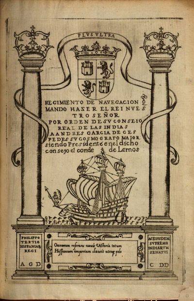
Why is the decolonization of the history of modern science and technology important? So that we can understand why Francis Bacon’s iconic title page image of a European caravella navigating through the pillars of Hercules in his book Instauratio Magna (Great Instauration, 1620) or Novum Organum Scientiarum (“new instrument of science”), which indicated the new program for modern empirical (colonial) scientific development, was actually taken from Andrés García de Céspedes’s book, Regimiento de navegación (Madrid, 1606). This shows the Northwestern European (Dutch, British, German), Protestant hegemonic shift, which stigmatized the downfall of “luxurious”, “inefficient”, “rapacious”, “unindustrialized”, “state-led capitalist” Spain, the Iberian or Southwestern European imperial-colonial project, against the “industrial revolution” and “scientific revolution” of the Northerners, the latter of which the image became a symbol. The deconstruction of this narrative is important in revealing the concealed global histories of colonial scientific and technological development, which was partly a precondition for the development in the new hegemonic centre in Europe. The South American decolonialist approach might be an important influence in decolonizing Eastern European knowledge production, since the Northwestern-Atlantic-Protestant narrative of scientific development, largely present in social scientists’ work such as Max Weber or Karl Marx, was dominantly diffused in Eastern Europe as our Eurocentric understanding of global scientific and economic development. I was educated according to this narrative already in primary school. This story will be included in my chapter on decolonizing Eastern European history of science and technology in the book Technosciences of Post/Socialism planned to be published somewhere in 2018.

Credit goes to Jorge Cañizares-Esguerra‘s work in which I’ve read about parts of the argument I am making. Read a brief overview on William Eamon’s blog.

For those more professionally engaged in the history of science, find a superb overview of annotated literature here.

The critical geographies of scientific knowledge and urban policy mobilities

On November 14, I will be holding a lecture and seminar in the frames of a lecture series about sustainable development in Central and Eastern Europe at Kaposvár University in Hungary.

The critical geographies of scientific knowledge and urban policy mobilities

Why and how do theories and policies travel? Who are involved in mobilizing and adapting them to local contexts and interests? What social groups do they affect and who benefits or gets disadvantaged? This class aims to encourage students to engage critically in these questions by introducing literature on the geographies of scientific knowledge and urban policy mobilities. These approaches argue that theories and policy models spread through transnational networks of communication, and their production and dissemination are conditioned by their sites, spaces, scales and circulations of operation. Increasing globalization has led to “fast policy”, “mobile urbanism”, and a global market of expertise and policy models in urban development, which called forth a relational view of cities against “cities-as-territories”.

The class first provides an overview of some considerations in analyzing historical, geographical, sociological and political aspects in the production of scientific knowledge, such as the notions of “truth spots”, “invisible colleges”, “gatekeepers of knowledge”, “scientific provincialism”, “travelling knowledge”, or the politics of translation. Second, we turn more specifically to the global circulation of urban policies, by showing the social and ideological contexts of the policy-making process, the politics of policy knowledge production, and the processes of policy circulation and adaptation. Third, after revising some popular examples of urban development models and their scientific legitimation, we focus more concretely on deconstructing the highly debated “creative city” concept.

By presenting a critical stance towards “successful” policies, “best practices” and policy branding, the class offers students tools to discover the uneasy dynamics between scientific knowledge and policy-making, and helps them develop their critical interpretative skills in understanding how development discourse and policy-making affects their urban environments.


Suggested reading for the class:

Peck, J. (2005): Struggling with the Creative Class. International Journal of Urban and Regional Research, 29(4): 740–770.

http://www.creativeclass.com

http://archive.sciencewatch.com/dr/fmf/2010/10novfmf/10novfmfPeck

Recommended literature:

Books:

Livingstone, D. N. (2003): Putting Science in its Place: Geographies of Scientific Knowledge. Chicago: University of Chicago Press.

McCann, E., Ward, K. (Eds.)(2011): Mobile Urbanism: Cities and Policymaking in the Global Age. Minneapolis and London: University of Minnesota Press.

Peck, J., Theodore, N. (2015): Fast Policy: Experimental Statecraft at the Thresholds of Neoliberalism. Minneapolis and London: University of Minnesota Press.

Articles:

Cook, I. R., Ward, K. (2011): Trans-urban Networks of Learning, Mega Events and Policy Tourism: The Case of Manchester’s Commonwealth and Olympic Games Projects. Urban Studies, 48: 2519–2535.

Gonzalez, S. (2011): Bilbao and Barcelona ‘in motion’. How urban regeneration ‘models’ travel and mutate in the global flows of policy tourism. Urban Studies, 48(7): 1397–1418.

Jacobs, J. M. (2012): Urban geographies I: Still thinking cities relationally. Progress in Human Geography, 36(3): 412–422.

Larner W., Laurie N. (2010): Travelling technocrats, embodied knowledges: Globalising privatisation in telecoms and water. Geoforum, 41: 218–226.

McCann, E. J. (2008): Expertise, Truth, and Urban Policy Mobilities: Global Circuits of Knowledge in the Development of Vancouver, Canada’s ‘Four Pillar’ Drug Strategy. Environment and Planning A, 40: 885–904.

McCann, E. J., Ward, K. (2010): Relationality/Territoriality: Towards a Conceptualization of Cities in the World. Geoforum, 41: 175–184.

McCann, E. J. (2011): Urban Policy Mobilities and Global Relational Geographies: Toward a Research Agenda. Annals of the Association of American Geographers, 101: 107–130.

McCann, E. J., Ward, K. (2014): Exploring Urban Policy Mobilities: The Case of Business Improvement Districts. Sociologica, 1: 1–20.

McCann, E. J., Ward, K. (2015): Thinking Through Dualisms in Urban Policy Mobilities. International Journal of Urban and Regional Research, 39(4): 828–830.

Oancă, A. (2015): Europe is not elsewhere: The mobilization of an immobile policy in the lobbying by Perm (Russia) for the European Capital of Culture title. European Urban and Regional Studies, 22(2): 179–190.

Peck, J., Theodore, N. (2010) Mobilizing policy: Models, methods, and mutations. Geoforum, 41 (2010) 169–174.

Pomfret, R., Wilson, J. K., Lobmayr, B. (2009): Bidding for Sport Mega-Events. School of Economics. Working Paper Series, 30.

Prince, Russel (2010): Globalizing the Creative Industries Concept: Travelling Policy and Transnational Policy Communities. The Journal of Arts Management, Law, and Society, 40: 119–139.

Ward, K. (2005): Entrepreneurial urbanism and the manage­ment of the contemporary city. The example of Busi­ness Improvement Districts. Transnational Seminar Lecture Paper, University of Illinois at Urbana-Cham­paign, Center for Global Studies.

Ward, K., Cook, I. R. (2012): Conferences, informational infrastructures and mobile policies: the process of getting Sweden ‘BID ready’. European Urban and Regional Studies, 19: 137–152.


This presentation received support from the “NKFIH K No. 115870” project entitled “Contemporary theories of space and spatiality in the Central Eastern European context” (“Kortárs térelméletek közép-kelet-európai kontextusban”) funded by the National Research, Development and Innovation Office (NRDIO) in Hungary.

Two new abstracts sent to ICHG2018 and AAG2018

My latest plan is to send two abstracts to the 17th International Conference of Historical Geographers in Warsaw, July 15-20 and one – the latter abstract here provided – to the Association of American Geographers Annual Meeting in New Orleans, April 10-14 in 2018. In the first case, the first abstract will hopefully be part of the following session:

– SESSION –

Global Histories of Geography 19301990

Convenors: Ruth Craggs (King’s College London) and Hannah Neate (Manchester Metropolitan University)

Reflecting on the key centres associated with the emergence of geography as a spatial science in the 1960s Barnes (2002, 508) remarked: “Why are places in Africa not on there, or Asia, or Australasia?” thereby highlighting significant gaps in disciplinary histories and accounts of geography’s development in the second half of the twentieth century. By way of response, this session aims to highlight work into the ‘global’ histories of geography in the period 1930-1990, a period marked by geopolitical transitions including WWII, decolonization and the end of the Cold War.  We are looking to make links with scholars who are carrying out research on the history and practice of geography, specifically in submissions that explore scholarly communities of geographers whose contribution to the development of geography in the twentieth century often goes unrecognised in the ‘canon’ of geographical research.

Possible themes for papers:

  • Papers focusing on geographers from the global South, Indigenous geographers in settler states, Asian geographies and geographers, geographers from the former Eastern Block
  • Biographies of individuals or groupings of geographers
  • Accounts that highlight how geography was being pursued in other ‘centres’
  • The role and development of national and international disciplinary associations and networks
  • Geographical knowledge, expertise and intersections with decolonization and the end of the Cold War

– ABSTRACTS –

Historical geographies of the “quantitative revolution”: Towards a transnational history of central place theory

Geography’s “quantitative revolution” has been a true textbook chronicle in the discipline’s canonical history. However, historical research has only recently seriously begun to unravel the geographical contexts of its emergence, which is complicated by the simplified narratives that emerged in critical revisionism from the 1970s. This paper offers an interpretative framework from the perspective of the historical geographies of scientific knowledge (HGSK), by focusing on Christaller’s central place theory (CPT) to deconstruct the common Anglo-American narrative, arguing that it has concealed other contexts in the “Second” and “Third” worlds. Early applications (especially in Germany, Poland, Netherlands, Israel) and the wider European discourse of “central places” call for a reevaluation of the canonized narratives of CPT. The globalization of CPT is interpreted through the rising American hegemony in the early Cold War era, which led to the Americanization of German location theories in modernization theory discourse. Networks behind the American, British and Canadian centres show the importance of European locations, such as the Swedish hub in Lund, and the “planning laboratories” of Asian, South American and African contexts after decolonization. Soviet and Eastern Bloc reformism and the institutionalization of regional planning from the late 1950s summoned CPT in the service of centralized state planning, and ignited debates of adaptability between “socialist” and “capitalist” contexts. By reflecting on some of these cases, this paper argues for a transnational history of CPT by readdressing issues of narrativity and historical periodization, and shows the need for provincializing and decolonizing dominant Anglo-American geographical knowledge production.


“The Ghana job”: Opening Hungary to the developing world

Based on interviews, archival and media sources, this paper looks at how post-WWII socialist Hungary developed foreign economic relations with decolonized countries, by focusing on the emergence of Hungarian development and area studies and development advocacy expertise towards developing countries. The paper’s case study is the Centre for Afro-Asian Research (CAAR) founded at the Hungarian Academy of Sciences in 1963 – from 1973 the Institute for World Economy (IWE) – parallel to similar institutions founded in the Soviet Union and other Eastern Bloc states. CAAR was established as a government think tank by József Bognár, a close friend to Prime Minister János Kádár and perhaps one of the most important figures in socialist era Hungarian reform economics and foreign policy-making. The institute rose as a consequence of the “Ghana job”: Hungarian economists led by Bognár developed the First Seven-Year Plan of Ghana in 1962. The associates of CAAR and IWE promoted export-oriented growth against import-substitution industrialization and summoned geographical development concepts such as “poorly developed countries”, “dependency”, “semiperiphery”, “open economies”, or “small countries” as alternatives to the Cold War categories of “capitalist” and “socialist” world systems. This shift in geographical knowledge production is connected to the geopolitical contexts of the Sino-Soviet split, the Khrushchevian “opening up” of foreign relations, the emergence of the “Third World”, and also the 1956 revolution in the case of Hungary. The role of Ghana and the Eastern Bloc is connected to the 1960s wave of transnational development consultancy and strategies of “socialist globalization”.

Speaking from the Semi-Periphery: Decolonizing Geographical Knowledge Production in Socialist Hungary, 1960s to 1980s

In recent months I’ve prepared a new research plan/paper on the stuff I’ve been doing, connected to my work in the 1989 After 1989 project:

The “spatial turn” in the history of scientific knowledge has called into question abstract notions of scientific development and specifically national disciplinary and institutional narratives. The past two decades has seen a growing number of studies in the historical geographies of scientific knowledge (HGSK), aiming to understand where knowledge is produced and disseminated, and how the content of knowledge changes in motion and adapts to local contexts and social interests (Livingstone 2003; Powell 2007; Withers 2009). Recently, increased globalization has summoned an upsurge of research focusing on interconnectedness through knowledge networks and circulations, transnational histories and global comparative studies, arguing against the “methodological nationalism” of previous research in favour of alternative transnational concepts (Keim et al. 2014; Conrad 2016).

On the other hand, postcolonial and decolonial approaches have contested Eurocentric or Westcentric epistemological frameworks and discursive formations, providing a reassessment of multiple or alternative modernities and elucidating the hierarchical orders of knowledge regimes (Chakrabarty 2007; Boatca and Costa 2012). However, much of this original literature on postcolonialism focused either on the global centre or the former colonial world, silencing in-between semiperipheral contexts such as Eastern Europe under transitory and provincialised terms such as “postsocialism,” while there has been little theorizing between the “posts” (Chari and Verdery 2009). This marginalization process has also led to the concealment of Second-Third World relations and the interdependency of centre and periphery contexts in an interconnected global context (Ward 2010; Mark and Apor 2014).

While the perceived non-colonial background of Eastern Europe provided excuses for many in the region to distance themselves from postcolonial studies (Moore 2001), historical studies have nevertheless shown the existence of long-term structures of hierarchical dependency and East-West “civilizational slopes” even since the Renaissance and the Enlightenment (Wolff 1994), which have well endured into socialist and postsocialist times (Melegh 2006). This continuity is well captured by the self-Orientalizing development and geographical concepts in social science, geography and economic history (Petrovici 2015). These can be exemplified by various contexts: the enduring dichotomies of “Eastern” and “Western” development (Éber et al. 2014), the “catching-up” neoliberalist transitology (Stenning and Hörschelman 2008), the “civilizing mission” of European Union accession (Böröcz and Sarkar 2005), the subaltern adaptation of development policy models, and the uneven reproduction of Western academic hegemony.

This research argues for “decolonizing” diffusionist and neoevolutionist theories that have been appropriated as the dominant narrative of the global centre and imposed upon the Eastern European context (Boatca and Costa 2012). Simultaneously it argues for a global perspective of transnational interconnectedness in understanding Eastern European developments in the production of geographical knowledge. It does so by using contemporary literature in critical geography and international relations, and specifically in postcolonial, decolonial theory and world-systems analysis to deconstruct internalised structures of dependency and global hierarchies inherent in Eastern European geographical epistemologies. By “speaking from the semiperiphery,” it aims to reassemble local knowledge production on global geographical concepts, in light of overlooked global historical interconnectivity between “East” and “West.” The research aims to apply these theoretical insights to understanding how Hungarian reform economists tried to position the country in various global imaginations between the 1960s and 1980s in the context of integrating into the world economy and thus breaking away with Cold War concepts amidst increasing global competition and economic restructuration due to crises.

After World War II, the imperialist and nationalist-revisionist ambitions of the Hungarian state elite crumbled with the demise of the previous “high imperialist” era. The Communist takeover and the process of Sovietization created a new setting under the imperial and colonial influence of the Soviet Union, and a rise of economist experts succeeding the pre-WWII primacy of geographers. Stalinist orthodoxy summoned a dichotomous Cold War imagination of separate “capitalist” and “socialist” worlds, soon to be called “world systems,” while the production of geographical knowledge and textbooks on regional geography also followed this essential dichotomy. But the détente period after de-Stalinisation and the gradual opening up of diplomatic and trade relations due to an economic upturn in the world economy and the process of decolonisation led to reconfigurations in global geographical and development imaginations.

The maintaining of the Eastern European “buffer zone” necessitated the Soviet Union to foster trade relations both with the West and the so-called Third World. Eastern European reformers in Poland and Hungary pushed towards “market socialism”, as acquiring advanced technology and foreign currency from the West implied finding ways to finance development either through foreign loans or export-oriented growth, and facilitated exporting expertise and investments into the Third World and searching for state-led development models abroad, such as in Spain, South Korea and Chile (Bockman, Feygin and Mark forthcoming). These reformist ambitions generated a virulent debate and the emergence of new geographical concepts connected to the country’s shifting foreign trade policies and lobbying activity in international organizations (UN, UNCTAD, GATT) in order to manoeuvre between “East” and “West.”

While the concept of the “Third World” was disregarded by Eastern European socialist countries, they aimed to reposition themselves between “developed” and “undeveloped” countries in an urge to “catch up” with the West. By the 1970s in Hungary, some new concepts such as “semi-periphery,” “small economies” (Kádár 1971), “open economies” (Kozma 1980) had emerged in the Centre for Afro-Asian Research (1965-) and the Institute for World Economy (1973-) at the Hungarian Academy of Sciences, which consequently developed the new field of area studies. In turn, some Western concepts, such as Wallersteinian world-systems analysis and the concept of “semiperiphery” were influenced by Eastern European economic historiography. In later developments, the series of Fejlődés-tanulmányok [Development Studies] published in 1978–1989 and journals such as Világtörténet [World History] introduced the new fields of development studies, world-systems analysis, centre-periphery thinking and postcolonial theory into the fields of area studies and international relations.

This research thus aims to understand through historical materials of scientific publications and policy papers connected to these institutions how alternative geographical conceptions of socialist globalization emerged and permeated global imaginations in area studies. The theoretical-methodological novelty of this research lies in connecting the approaches of transnational or global history, political economy and the history of ideas: Hungarian semiperipheral knowledge production is conceptualised in the interconnected contexts of centre-periphery relations.

References

Boatca, M., Costa, S. (2012): Postcolonial Sociology: A Research Agenda. In: Rodríguez, E. G., Boatca, M. (eds.): Decolonizing European Sociology: Transdisciplinary Approaches. Farnham and Burlington: Ashgate Publishing.

Bockman, J., Feygin, Y., Mark, J. (forthcoming): The Soviet Union, Eastern Europe and Alternative Globalisations 1950s–1980s. Manuscript.

Böröcz, J., Sarkar, M. (2005): What is the EU? International Sociology, 20(2): 153–173.

Chakrabarty, D. (2007): Provincializing Europe: Postcolonial Thought and Historical Difference. Princeton: Princeton University Press.

Chari, S., Verdery, K. (2009): Thinking Between the Posts: Postcolonialism, Postsocialism, and Ethnography after the Cold War. Comparative Studies in Society and History, 51(1): 6–34.

Conrad, S. (2016): What is Global History? Princeton: Princeton University Press.

Éber, M., Gagyi, Á., Gerőcs, T., Jelinek, C., Pinkasz, A. (2014): 1989: Szempontok a rendszerváltozás globális politikai gazdaságtanához. Fordulat, 21.: 10–63.

Gille, Z. (2010): Is there a Global Postsocialist Condition? Global Society, 24(1): 9–30.

Kádár, B. (1971): Kis országok a világgazdaságban. Budapest: Közgazdasági és Jogi Könyvkiadó.

Keim, W., Celik, E., Erche, C., Wöhrer, V. (eds.)(2014): Global Knowledge Production in the Social Sciences: Made in Circulation. Corchester (UK): Ashgate.

Kozma, F. (1980): A nyitott szerkezetű gazdaság. Budapest: Kossuth.

Livingstone, D. N. (2003): Putting Science in its Place: Geographies of Scientific Knowledge. Chicago: University of Chicago Press.

Mark, J., Apor, P. (2014): Socialism Goes Global: Decolonization and the Making of a New Culture of Internationalism in Socialist Hungary, 1956–1989. The Journal of Modern History, 87: 852–891.

Melegh, A. (2006): On the East-West Slope: Globalization, Nationalism, Racism and Discourses on Central and Eastern Europe. Budapest: CEU Press.

Moore, D. C. (2001): Is the Post- in Postcolonial the Post- in Post-Soviet? Toward a Global Postcolonial Critique. PMLA, 116(1): 111–128.

Petrovici, N. (2015): Framing Criticism and Knowledge Production in Semi-peripheries: Post-socialism Unpacked. Intersections, 1(2):

Powell, R. C. (2007): Geographies of Science: Histories, Localities, Practices, Futures. Progress in Human Geography, 31(3): 309–329.

Stenning, A., Hörschelman, K. (2008): History, Geography and Difference in the Post-Socialist World: Or, Do We Still Need Post-Socialism? Antipode, 40(2): 312–335.

Ward, S. (2010): Transnational Planners in a Postcolonial World. In: Healey, P., Upton, R. (eds.): Crossing Borders: International Exchange and Planning Practices. London and New York: Routledge. 47–72.

Withers, C. W. J. (2009): Place and the “Spatial Turn” in Geography and in History. Journal of the History of Ideas, 70(4): 637–658.

Wolff, L. (1994): Inventing Eastern Europe: The Map of Civilization on the Mind of the Enlightenment. Stanford University Press.

The European Regional Conference of the International Geographical Union in Budapest (1971)

In my research, I am gathering all important international conferences and meetings attended by Hungarian geographers and spatial planners in the socialist era. One of the main networks between East and West were the International Geographical Union’s world congresses. The first of these world congresses, where the USSR and Eastern European members attended was the one in 1960 in Stockholm. This showed the post-Stalin era’s softening of isolationist politics and geopolitical tensions, and the world economy’s “boom era” from the end of the 1950s and throughout the 1960s. Urban and regional planning thus came to the fore, with specialists in planning establishing more and more professional connections internationally. But for Hungarian geographers and regional planners, and probably much for East and West connections, probably the most important of these meeting was the European Regional Conference of the International Geographical Union organized in Hungary in 1971. As the organizers wrote in their report to the journal Geoforum:

“Another important attractive force was the fact that the Budapest conference was the first real East-West meeting in the realm of the geographical sciences; approximately 40% of the participants represented the socialist countries.

The conference had 734 registered and attending members from 34 countries. Several people had themselves registered as “non-participating” members in order to receive the interesting publication material. The largest foreign delegation arrived from the Soviet Union – 114. This was followed by the Federal Republic of Germany – 47, United States – 45, Czechoslovakia – 33, and France – 32. The majority of the participants naturally came from Europe, although all the continents were “present” at our conference.

The conference may play a very significant role in the future development of Hungarian geography and the expansion of our international relations. It happened for the first time that we had the opportunity to give an account of the results of the full scope of Hungarian geographical research projects, because of previoussimilar meetings only a few of our scientists had been able to attend. Many of our young research workers participated for the first time in an international meeting of this kind. They had the opportunity of listening to the excellent lectures of prominent representatives of their professional field and to the reports of the most recent results of research, much of which is still unpublished. ” (Enyedi – Marosi 1972: 86, 88)

The preparations for this conference started in 1969, when the Hungarian Academy of Sciences entrusted the Geographical Research Institute with its organization. It took place between 10-14 August 1971 at the Karl Marx University of Economics, Budapest. As many of these congresses of the time, its main topics – where most of the papers were coming in – were urbanization and regional planning. This conference was part of the enormous effort of György Enyedi in establishing Hungarian geography’s international relations, and from the 1970s, Hungarian geographers came much more in the perception of the West.

I have just excavated the conference book of abstracts, so I’m doing a short analysis on this (Lackó – Piroska 1971).

György Enyedi, Sándor Marosi (1972):European Regional Conference of the International Geographical Union. Geoforum, 9: 85-88.
Lackó László, Polyánszky Piroska (1971): International Geographical Union European Regional Conference, Hungary, 1971: Abstracts of Papers – Supplement. MTA KESZ, Budapest.