The forgotten Polish link in the global history of the “quantitative revolution”

In textbook chronicles, the “quantitative revolution” marked a historical moment when geography became a true Cold War science. As a result of the Second World War, a new generation of geographers left their parochial disciplinary chambers and idiographic methods to turn towards an interdisciplinary approach by adopting the universal “scientific method”, and pursue rigorous, testable mathematical methods in spatial analysis and a positivistic urge to apply deductive theories in spatial planning, modernization and development. An inevitable element of this change was the (re)discovery of German location theories (von Thünen 1826, Weber 1909), including the central place theory of Walter Christaller (1933) and August Lösch (1940), which revolutionized the field of urban geography and regional planning.

The hexagonic model of central places (settlements) by Walter Christaller, 1933

However, anti-positivist critique in the West since the late 1960s has greatly simplified these historical contexts, and the knowledge geographies, wider geographical conditions and knowledge networks of the “quantitative revolution” have remained unexplored. The “revolution” was actually an emerging hegemonic narrative of academics in the global center of North America and Britain, who appropriated interwar era German location theories for their own local pursuits with the help of their postwar academic alliance with Swedish geographers.

Polish regional plans of central places by the National Office of Spatial Planning (Główny Urząd Planowania Przestrzennego) in Warsaw, 1948

But missing from this transnational history is the early postwar school of Polish geography and spatial planning, which became an important precursor in the wider history of the centralized state being involved in the regional planning of settlements. This article shows how the various contexts of European state-led applications of central place theory – disregarded by liberal capitalists in the West – connected across statist regimes, by focusing on how Walter Christaller’s central place theory was applied in the German colonization of Poland by the Nazis during the Generalplan Ost (1940–43) and then in postwar Polish spatial planning under the nation-wide reconstruction orchestrated by the National Office of Spatial Planning (1946–48), which relied on this same German planning knowledge. The remarkable continuity between the Nazi German and postwar Polish contexts gave Polish geographers an advantage to be later included in the American-led Western knowledge networks of the “quantitative revolution” from the late 1950s on, despite the Iron Curtain.

The Nazi settlement system plan of the Eastern annexed territories, including Poland, for the Generalplan Ost by Walter Christaller, 1941

© Copyright – Content is protected by copyright!

Citation:

Ginelli Z. (2020): The forgotten Polish link in the global history of the “quantitative revolution”. Critical Geographies Blog, 2020.01.01. Link: /2020/01/01/the-forgotten-polish-link-in-the-global-history-of-the-quantitative-revolution/

Tracing the Global History of the Quantitative Revolution: The Transnational History of Central Place Theory

christaller_cpt2

Zoltán Ginelli

Book Plan

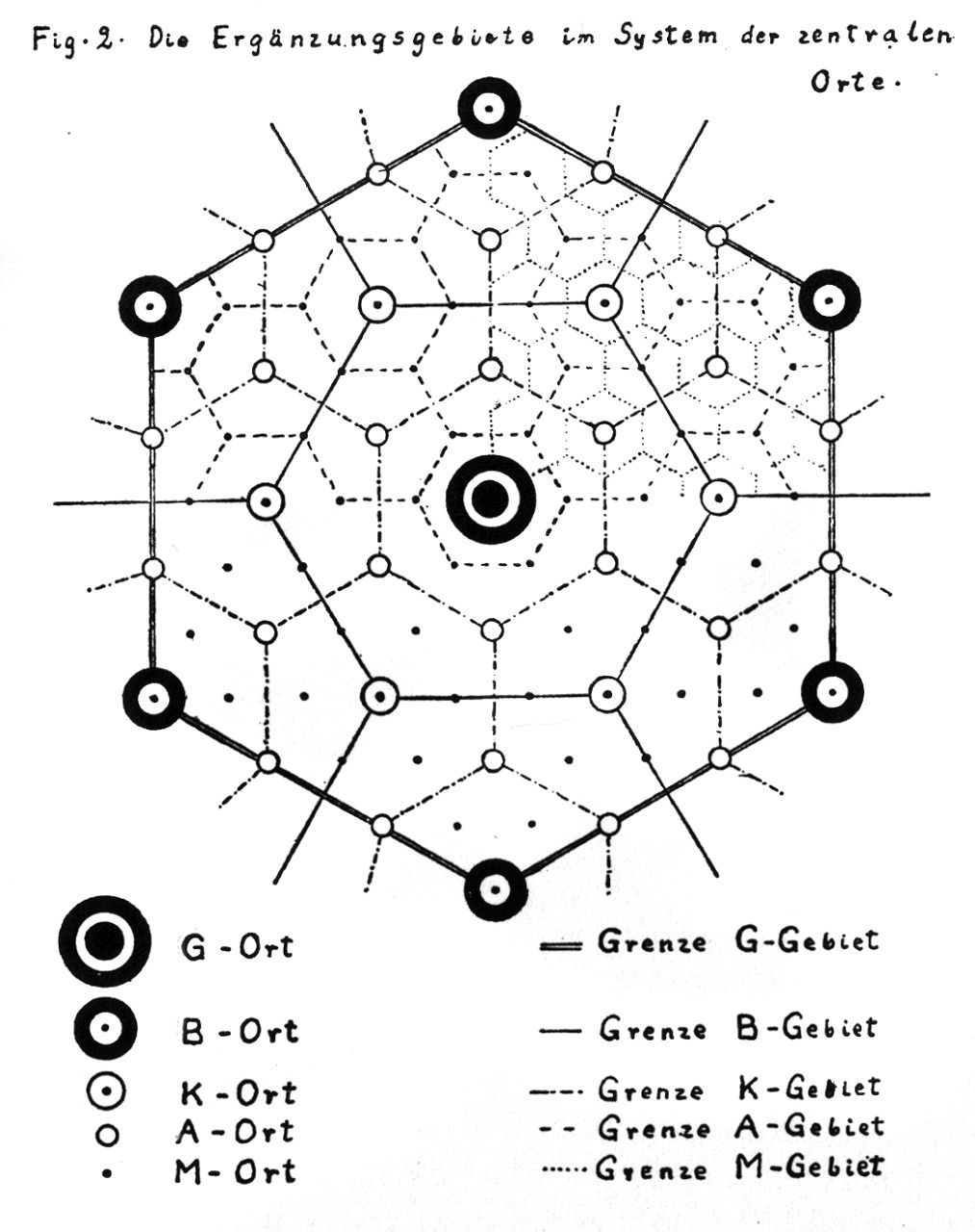
The quantitative revolution has been an epochal textbook chapter in geography’s canonical history, marking a time when the discipline transformed into a rigorous social science backed by predictive mathematical methods in the early Cold War. An iconic scientific concept of this quantitative movement, most notably related to Walter Christaller (1933) and August Lösch (1939), was central place theory (CPT), which postulated a triangular-hexagonal structure of hierarchical settlement systems based on marginalist economics and behaviourist assumptions. It was a foundational theory for the emerging field of spatial analysis, including regional science (Isard, 1956) and regional or urban economics. With the intensive globalization of the quantitative revolution after its emergence from the Second World War in the United States (Barnes and Farish 2006), location theories such as CPT became very influential and widespread in urban and regional planning across the entire world. But in the West, vigorous efforts to criticise spatial science from the 1970s onwards (e.g. Gregory, 1978) developed a revisionist narrative that stressed the influence of positivism, rationalism, technocratism, and Cold War American hegemony. This ultimately added to the already reduced view of actual historical events (Livingstone, 1992; cf. Van Meeteren, forthcoming), while recent research has only begun to unravel the variegated geographical contexts of the quantitative revolution (e.g. Barnes, 2003). Reflecting on its initial North American centres, Barnes (2002, 508) passingly remarked: “Why are places in Africa not on there, or Asia, or Australasia?” Following Barnes’s plea for a more wider interpretation, we attempt to pose a number of questions. How did quantitative spatial analysis and planning develop in different parts of the world? In what different geographical contexts were location theories like CPT read, reinterpreted, applied, and mobilized? How were these often very different contexts connected?

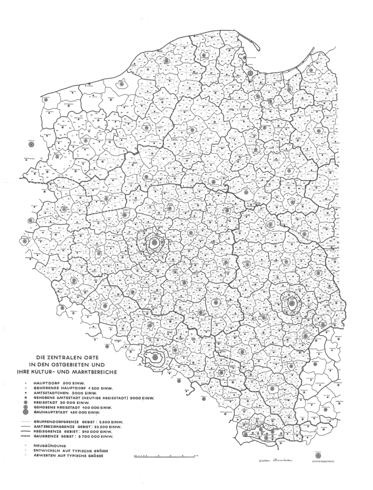
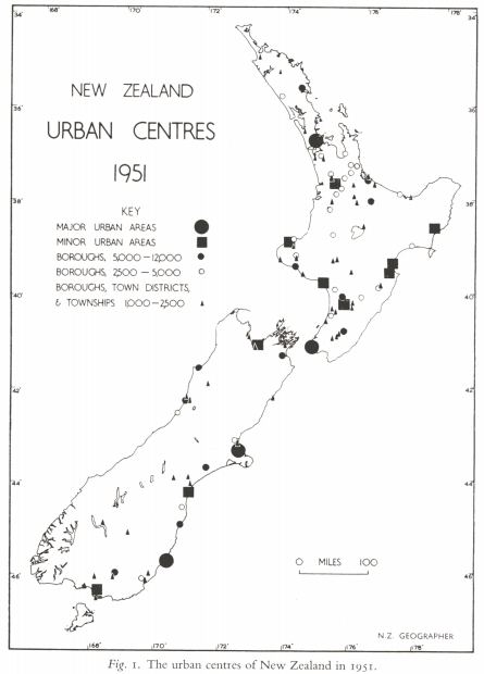
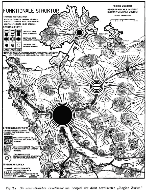
This book offers to fill this significant gap in geography’s twentieth century global history by following a transnational framework based on the historical geographies of scientific knowledge (Livingstone, 2003; Withers, 2007). It aims to deconstruct the mainstream Anglo-American narrative by tracing the quantitative revolution through the circulation and local applications of CPT in the “Second” and “Third” worlds and also into the pre-Cold War era (Ginelli 2018; Ginelli, in preparation). CPT was abstracted and canonized pragmatically by American-led spatial science despite originating from a much wider and more complex European interwar discourse than commonly appreciated (Radeff, 2012; Van Meeteren and Poorthuis, 2018). Antecedents reached into late 18th and 19th century ideas by German, French, and Swiss political economists, engineers, mathematicians, and geographers (Istel, 2002), and the so-called Garden City Movement across Europe (Fehl, 1992). The discussion of location theories grew rapidly in interwar Europe, as the Great Depression (192933) and world economic crisis ignited state-led interventionism and technocratism, which was embedded in a transnational discourse of rationalizing reforms by emerging administration science and regional planning, the application of functionalist and modernist ideas, Fordist-Taylorist development, mathematical economics, and long-term planning that disregarded ideological barriers. During the Second World War, CPT was intensively applied by Christaller under the “reactionary modernist” Nazi regime to plan the colonization and German resettlement of Poland by the Third Reich (Generalplan Ost) (e.g. Rössler, 1989; Preston, 2009; Barnes and Minca, 2013). Notable early applications included Estonia (Kant, 1935), the Nordoostpolder settlements in the Netherlands in the 1940s (Bosma 1993), the new settlements of expanding Israel in the mid-1950s (Trezib, 2014), research and application in regional planning in Britain (e.g. Dickinson, 1942; Smailes, 1944), introduction to the USA (Ullman, 1941; Brush, 1953; Berry & Garrison, 1958), and the regional planning of Sweden (e.g. Godlund, 1951). The yet weak American, British, and Canadian network of the quantitative movement was supported by the Swedish hub in Lund, which was also important in disseminating the application of location theories into Scandinavia and other parts of Europe in the 1960s (Barnes and Abrahamsson, 2017; Van Meeteren, in preparation). The Anglo-American impulse traversed easily into other Anglophone contexts such as Australia and New Zealand (e.g. Duncan 1955), and reached France through Canada in Francophone networks (Cuyala, 2015), while it helped legitimize the German reinvigoration of CPT in the 1960s in face of its wartime burden (Kegler, 2015).

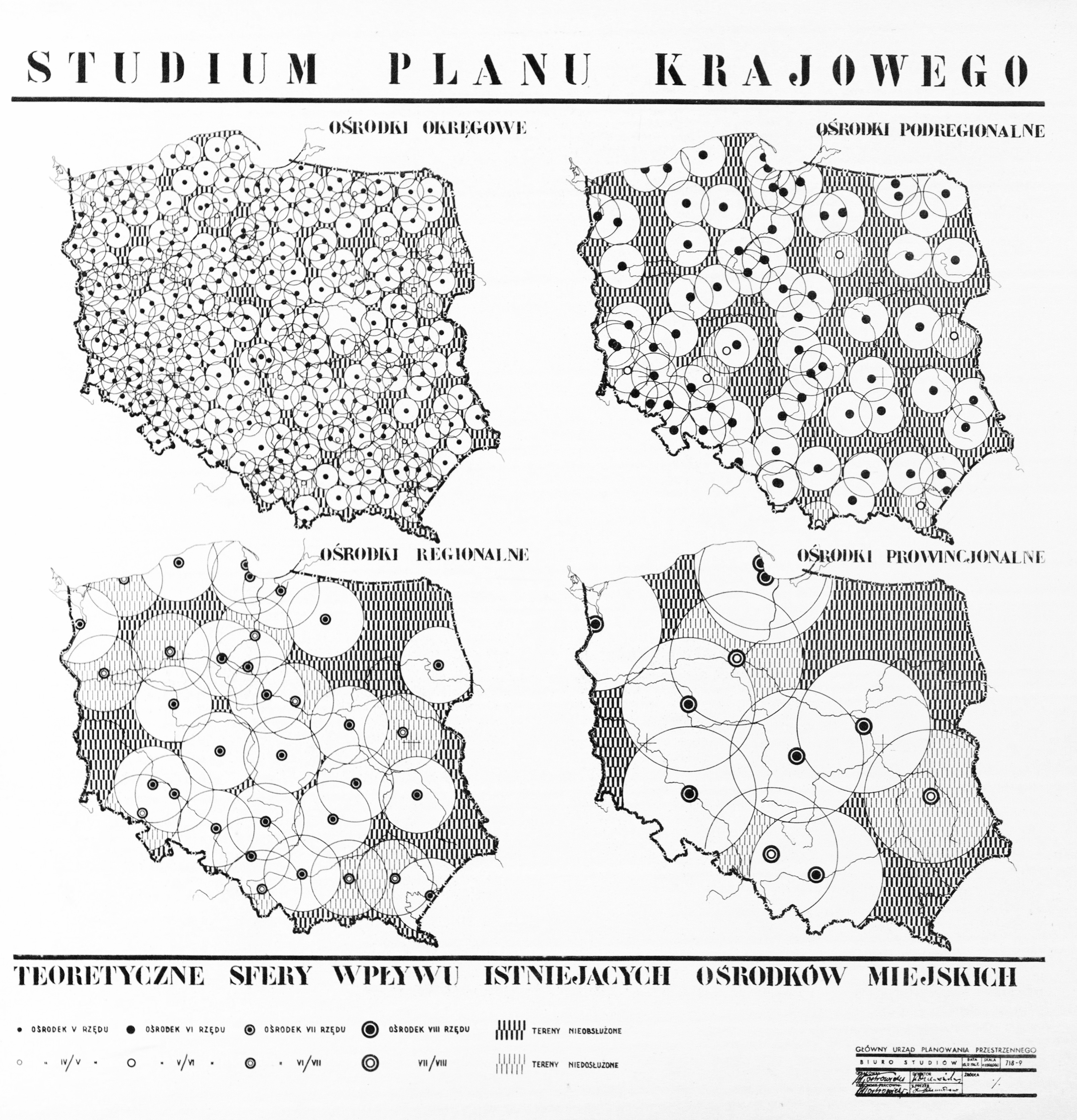
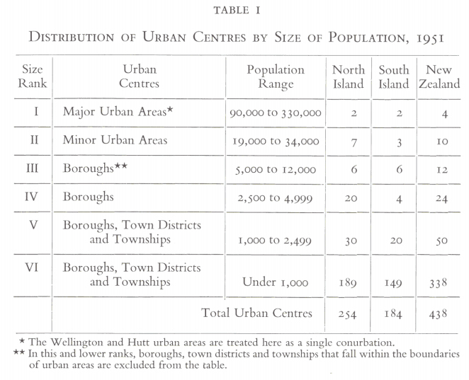
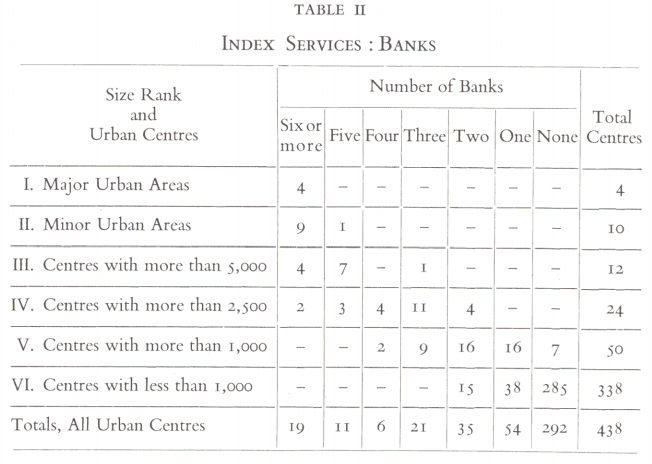
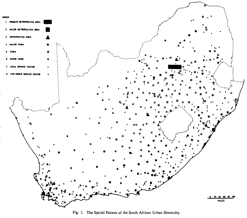
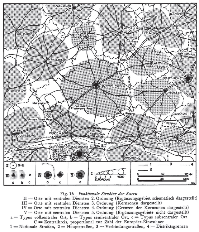
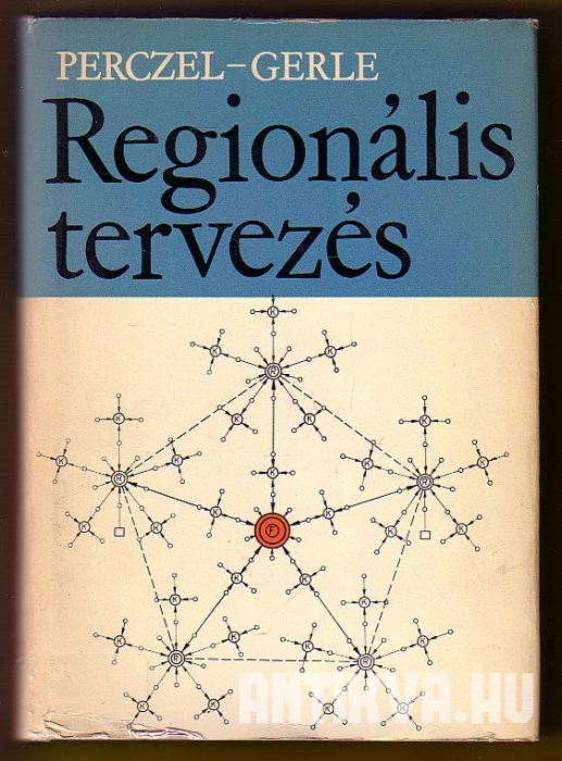
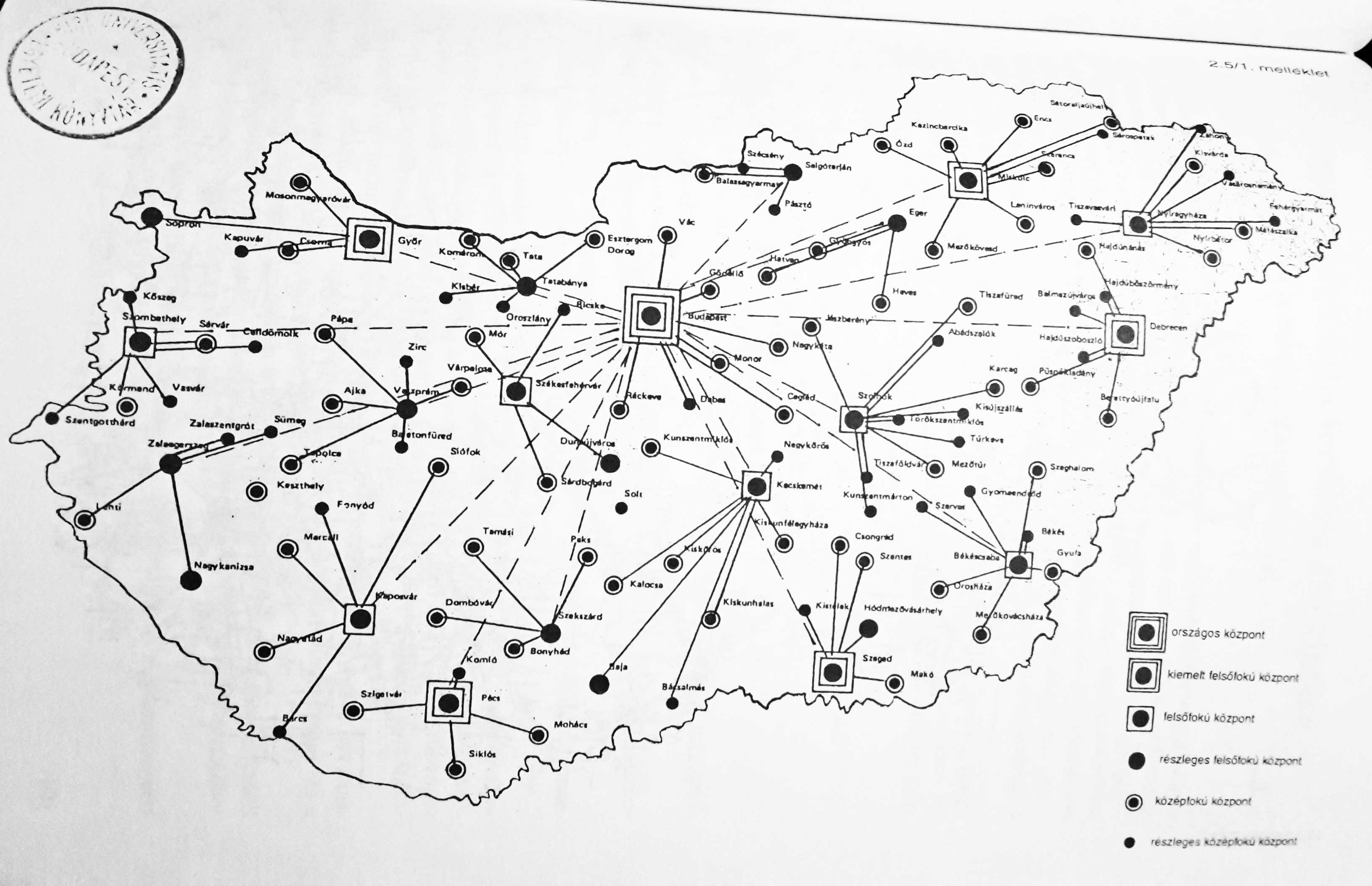
These mostly North Atlantic and Western, Central, and Northern European cases were followed by parallel developments and were increasingly connected into a global network despite Cold War ideological tensions, especially through international organizations such as the International Geographical Union and urban or regional planning organizations. The globalization of CPT under American Cold War hegemony from the early 1960s led to the Americanization of German location theories in an economistic modernization discourse, supported by USAID, United Nations, and World Bank projects. CPT became an important instrument of state-interventionist modernization and urbanization policies in the “planning laboratories” of the Global South, embedded in existing and emerging postcolonial knowledge networks devised by important centres of the quantitative revolution (Ginelli, in preparation). Early applications in India were followed by various others in South East Asia, West Asia (Clark & Costello 1973), and also East Asia (Ullman 1956), such as China (Skinner, 1964) and Japan (Hayashi, 1973). New statistical surveys and development projects made possible mostly American or British initiatives of applying CPT in African countries, such as Ghana (Grove & Huszár, 1964; Gould; McNulty 1969), Nigeria (Mabogunje, 1968), Kenya (Soja, 1968), South Africa (Carol, 1952; Davies, 1967) amongst many others. In South America, development projects in Peru, Chile (Berry, 1969), Colombia, or Bolivia also applied CPT, and the quantitative revolution spread through modernizing regimes as the case of Brazil suggests (Lamego, 2015; 2016). A number of comparative and critical works of applying CPT in the Global South appeared (e.g. Kuklinski 1978). In the socialist world, after the Stalinist purge of internationally renowned mathematical economics during the 1930s and 1950s, there developed a parallel “mathematical thrust” and growing East-West exchange during the détente of the 1960s (Jensen & Karaska, 1969; Saushkin, 1971). Soviet and Eastern Bloc reformism and the institutionalization of urban and regional planning in the mid-1950s summoned CPT in the service of centralized and long-term state planning, which ignited debates of adaptability between “socialist” and “capitalist” contexts, and also between domestic industrial or welfare policies (Ginelli, forthcoming). CPT strongly influenced the national urban and regional planning concepts of Eastern European countries, where it was already well known, Hungary, Yugoslavia, Poland, Czechoslovakia, and Romania (e.g. Perczel & Gerle, 1966; Vrišer, 1971). Apart from diffusing through Comecon plan coordination, socialist planning discourse borrowed from a transnational pool of knowledge. Quite remarkably, the seemingly “neutral” mathematical-geometrical language of CPT and the political demand for national development plans interweaved “socialist” and “capitalist” contexts, which held important continuities into the postsocialist era (Ginelli, forthcoming; in preparation). With the “new economic geography” emerging in the 1990s, the already developed canon of location theories such as CPT were solidified in neoclassical economics and neoliberal policies connected to a new regionalism.

Drawing on a number of such case studies, this book project aims to connect, contest, and contribute to various fields in the history of scientific knowledge. First of all, it explores the global histories of geography, regional science, urban studies, economics, and related fields in a period marked by geopolitical transitions such as the Second World War, decolonization, and the end of the Cold War. Arguing for a global discourse of CPT, this book contests current disciplinary accounts by re-addressing issues of narrativity, historical periodization, and geographical foci. It aims to broaden the fields of intellectual history and the sociology of science by connecting to the approach of science and technology studies to trace the spatial biographies of various actors, including people, ideas, theories, data, practices, technologies, or capital (e.g. Daston 2000). The yet unwritten transnational history of CPT and spatial analysis fits into the burgeoning literature on the transnational histories of Cold War technosciences, such as mathematical economics, statistical analysis, cybernetics, ekistics, systems theory, linear programming, game theory, or diffusion analysis (e.g. Andersson & Rindzeviciute 2015). This book also contributes to the growing studies of architectural history and policy mobilities, and the history of urban and regional planning with the aim to rethink postwar planning history (Ward, 2010; Wakeman 2014). On a further account, the book reveals the uneven power relations in global knowledge production and thereby adds to postcolonial and decolonial studies by decentering dominant Anglo-American knowledge production by focusing on interconnectivity and peripheralized contexts.

References

Andersson, J. & Rindzeviciute, E. (eds.)(2015): The Struggle for the Long-Term in Transnational Science and Politics: Forging the Future. London: Routledge.

Barnes, T. J. (2002): Performing economic geography: two men, two books, and a cast of thousands. Environment and Planning A, 34: 487–512.

Barnes, T. J. & Minca, C. (2012): Nazi Spatial Theory: The Dark Geographies of Carl Schmitt and Walter Christaller. Annals of the Association of American Geographers, 103(3): 669–687.

Barnes, T. J. & Abrahamsson, C. C. (2017): The imprecise wanderings of a precise idea: The travels of spatial analysis. In Jöns, H., Meusburger, P. and Heffernan, M. (eds.): Mobilities of Knowledge. Dordrecht: Springer. 105–121.

Berry, B. J. L. & Garrison, W. L. (1958): The functional bases of the central place hierarchy. Economic Geography,
34(2): 145–154.

Berry, B. J. L. (1969): Relationships between Regional Economic Development and the Urban System: The Case of Chile. Tijdscrift voor Economische en Sociale Geografie, 60: 283–307.

Bosma, K. (1993): Verbindungen zwischen Ost- und Westkolonisation. In: Rössler, M., Schleiermacher, S. (eds.): Der “Generalplan Ost”: Hauptlinien der nationalsozialistischen Planungs- und Vernichtungspolitik. Berlin: Akademie Verlag. 198–214.

Brush, J. E. (1953): The Hierarchy of Central Places in Southwestern Wisconsin. Geographical Review, 43(3): 380-402.

Carol, H. (1952): Das Agrageographische Berachtungssystem. Ein Beitrag zur Landschaftkundlichen Methodik dargelegt am Beispiel der in Südafrika. Geographica Helvetica, 1: 17–67.

Christaller, W. (1933): Die zentralen Orte in Süddeutschland. Jena: Gustav Fischer.

Clark, B. D. & Costello, V. (1973): The Urban System and Social Patterns in Iranian Cities. Transactions of the Institute of British Geographers, 59: 99–128.

Cuyala, S. (2015): Mapping the sources of diffusion and the active movements of scientists by using a
corpus of interviews: An experiment about the origins of theoretical and quantitative geography in French-speaking Europe. Terra Brasilis (Nova Série), 5.

Davies, R. J. (1967): The South African urban hierarchy. South African Geographical Journal, 49(1): 9–20.

Daston, L. (ed.)(2000): The Biographies of Scientific Objects. Chicago & London: The University of Chicago Press.

Dickinson, R. E. (1947): City, Region and Regionalism. London: Meuthen.

Duncan, J. C. (1955): New Zealand Towns as Services Centres. New Zealand Geographer, 11(2): 119–138.

Fehl, G. (1992): The Nazi Garden City. In: S. V. Ward (ed.): The Garden City: Past, Present and Future. Milton Park & New York: Taylor and Francis. 88–106.

Ginelli, Z. (in preparation) The historical geographies of the “quantitative revolution”: Towards a transnational history of central place theory. Ph.D. Dissertation. Budapest: Eötvös Loránd University, Faculty of Science, Doctoral School of Earth Sciences, Geography-Meteorology Program.

Ginelli, Z. (2018, forthcoming): Globalizing the “quantitative revolution”: The “technocratic turn” in geography and spatial planning in socialist Hungary. In: Idem (ed.) Technosciences of Post/socialism.

Ginelli, Z. (2018): Critical Remarks on the “Sovietization” of Hungarian human geography. In:

Godlund, S. (1951): Bus Services, Hinterlands and the Location of Urban Settlements in Sweden, especially in Scania. Lund.

Gregory, D. J. (1978): Ideology, Science and Human Geography. London: Hutchinson & Co.

Grove, D. J. & Huszár, L. I. (1964): The Towns of Ghana. Accra: Ghana Universities Press.

Gunawardena, K. A. (1964): Service centres in southern Ceylon. University of Cambridge, PhD Thesis.

Hayashi, N. (1973): On the Spatial Features of the Central Functions in Tokai Area. The Human Geography, 25: 26-52.

Istel, W. (2002): Zentrale Orte und ihre Einzugsbereiche. Theorien, empirische Untersuchungen, raumordnerische Anwendungen bis 1945. Ein Lese- und Lehrbuch in zwei Teilen. Tl.1. Prae Christaller. Zentrale-Orte-Theorien und empirische Zentralitätsuntersuchungen zwischen 1809 und 1933/34. Entmytholosierung einer Theorie, München : Fachgebiet Raumforschung, Raumordnung u. Landesplanung, Techn. Univ. München.

Jensen, R. G. & Karaska, G. J. (1969): The mathematical thrust in Soviet economic geography: Its nature and significance. Journal of Regional Science, 9: 141–152.

Kant, E. (1935): Bevölkerung und Lebensraum Estlands. Ein Anthropoökologischer Beitrag zur Kunde Baltoskandias. Tartu: Akadeemiline kooperatiiv.

Kegler, K. R. (2015): Deutsche Raumplanung. Das Modell der “Zentralen Orte” zwischen NS-Staat und Bundesrepublik. Paderborn: Ferdinand Schöningh.

Kuklinski, A. (ed.)(1978): Regional Policies in Nigeria, India and Brazil. The Hague: Mouton de Gruyter.

Lamego, M. (2015): Genius loci Duas versões da geografia quantitativa no Brasil. [Genius loci: two versions of quantitative geography in Brazil.] Terra Brasilis (Nova Série), 5: 114.

Lamego, M. (2016): Sobre a geografia da ciência: perspectivas locais e transnacionais nas histórias da geografia quantitativa brasileira. [On the geography of science: local and transnational perspectives in Brazilian quantitative geography]

Livingstone, D. N. (1992): The Geographical Tradition: Episodes in the History of a Contested Enterprise. Malden and Oxford: Wiley-Blackwell.

Livingstone, D. N. (2003): Putting Science in Its Place: Geographies of Scientific Knowledge. Chicago: University of Chicago Press.

Lösch, A. (1939): Die räumliche Ordnung der Wirtschaft. Eine Untersuchung über Standort, Wirtschaftsgebiete und internationalem Handel. Fischer, Jena.

Mabogunje, A. L. (1968): Urbanization in Nigeria. London: London University Press.

McNulty, M. L. (1969): Urban Structure and Development: The Urban System of Ghana. Journal of Developing Areas, 3: 159–176.

Michel, B. (2016): Strukturen Sehen. Über die Karriere eines Hexagons in der quantitativen Revolution. Geographica Helvetica, 71: 303–317.

Nicolas, G. (2009): Walter Christaller From “exquisite corpse” to “corpse resuscitated”. SAPIENS, 2.2.

Nicolas, G. & Radeff, A. (2015): Walter Christaller: les “principes” (“Prinzipien”) d’un géographe totalitaire opportuniste. Cyberato, Alter-perspectives disputables, Rubrique: Publications, Travaux et Mémoires, août 2015. www.cyberato.org

Perczel, K. & Gerle, G. (1966): Regionális tervezés és a magyar településhálózat [Regional Planning and the Hungarian Settlement Network]. Budapest: Akadémiai Kiadó.

Perera, N. (2010): When Planning Ideas Land: Mahaweli’s People-Centred Approach. In: P. Healey & R. Upton (eds.): Crossing Borders: International Exchange and Planning Practices. London & New York: Routledge. 141172.

Radeff, A. (2012): Hexagones sans centre, centres sans hexagone. Géographes de langue allemande et système christallérien, 1933-2010. [Hexagons without center, centers without hexagon. German speaking geographers and Christallerian system, 1933–2010.]

Rössler, M. (1989): Applied geography and area research in Nazi society: Central place theory and planning, 1933–1945. Environment and Planning D: Society and Space, 7: 419–431.

Saushkin, Y. G. (1971): Results and prospects of the use of mathematical methods in economic geography. Soviet Geography, 12(4): 416–427.

Skinner, G. W. (1964): Marketing and social structure in rural China. Journal of Asian Studies, 34.

Smailes, A. E. (1944): The urban hierarchy in England and Wales. Geography, 29(2): 41–51.

Soja, E. W. (1968): The Geography of Modernization in Kenya: A Spatial Analysis of Social, Economic, and Political Change. Syracuse, NY: Syracuse University Press.

Trezib, N. (2014): Die Theorie der zentralen Orte in Israel und Deutschland: Zur Rezeption Walter Christallers im Kontext von Sharonplan und “Generalplan Ost”. Oldenbourg: De Gruyter.

Van Meeteren, M. (2018, forthcoming): Statistics do sweat: Situated messiness and spatial science. Transactions of the Institute of British Geographers.

Van Meeteren, M. & Poorthuis, A. (2018): Christaller and “big data”: recalibrating central place theory via the geoweb. Urban Geography, 39(1): 122–148.

Van Meeteren, M. (in preparation) Writing blue notes in the march of geographical history: Revisiting the 1960 Lund Seminar in Urban Geography.

Vrišer, I. (1971): The pattern of central places in Yugoslavia. Tijdschrift voor economische sociale geographie, 62: 290–300.

Wakeman, R. (2014): Rethinking postwar planning history. Planning Perspectives, 29(2): 153–163.

Ward, S. (2010): Transnational Planners in a Postcolonial World. In: P. Healey & R. Upton (eds.): Crossing Borders: International Exchange and Planning Practices. London & New York: Routledge. 47–72.

Withers, C. W. J. (2009): Place and the “Spatial Turn” in Geography and History. Journal of the History of Ideas, 70(4): 637–658.

Two new abstracts sent to ICHG2018 and AAG2018

My latest plan is to send two abstracts to the 17th International Conference of Historical Geographers in Warsaw, July 15-20 and one – the latter abstract here provided – to the Association of American Geographers Annual Meeting in New Orleans, April 10-14 in 2018. In the first case, the first abstract will hopefully be part of the following session:

– SESSION –

Global Histories of Geography 19301990

Convenors: Ruth Craggs (King’s College London) and Hannah Neate (Manchester Metropolitan University)

Reflecting on the key centres associated with the emergence of geography as a spatial science in the 1960s Barnes (2002, 508) remarked: “Why are places in Africa not on there, or Asia, or Australasia?” thereby highlighting significant gaps in disciplinary histories and accounts of geography’s development in the second half of the twentieth century. By way of response, this session aims to highlight work into the ‘global’ histories of geography in the period 1930-1990, a period marked by geopolitical transitions including WWII, decolonization and the end of the Cold War.  We are looking to make links with scholars who are carrying out research on the history and practice of geography, specifically in submissions that explore scholarly communities of geographers whose contribution to the development of geography in the twentieth century often goes unrecognised in the ‘canon’ of geographical research.

Possible themes for papers:

  • Papers focusing on geographers from the global South, Indigenous geographers in settler states, Asian geographies and geographers, geographers from the former Eastern Block
  • Biographies of individuals or groupings of geographers
  • Accounts that highlight how geography was being pursued in other ‘centres’
  • The role and development of national and international disciplinary associations and networks
  • Geographical knowledge, expertise and intersections with decolonization and the end of the Cold War

– ABSTRACTS –

Historical geographies of the “quantitative revolution”: Towards a transnational history of central place theory

Geography’s “quantitative revolution” has been a true textbook chronicle in the discipline’s canonical history. However, historical research has only recently seriously begun to unravel the geographical contexts of its emergence, which is complicated by the simplified narratives that emerged in critical revisionism from the 1970s. This paper offers an interpretative framework from the perspective of the historical geographies of scientific knowledge (HGSK), by focusing on Christaller’s central place theory (CPT) to deconstruct the common Anglo-American narrative, arguing that it has concealed other contexts in the “Second” and “Third” worlds. Early applications (especially in Germany, Poland, Netherlands, Israel) and the wider European discourse of “central places” call for a reevaluation of the canonized narratives of CPT. The globalization of CPT is interpreted through the rising American hegemony in the early Cold War era, which led to the Americanization of German location theories in modernization theory discourse. Networks behind the American, British and Canadian centres show the importance of European locations, such as the Swedish hub in Lund, and the “planning laboratories” of Asian, South American and African contexts after decolonization. Soviet and Eastern Bloc reformism and the institutionalization of regional planning from the late 1950s summoned CPT in the service of centralized state planning, and ignited debates of adaptability between “socialist” and “capitalist” contexts. By reflecting on some of these cases, this paper argues for a transnational history of CPT by readdressing issues of narrativity and historical periodization, and shows the need for provincializing and decolonizing dominant Anglo-American geographical knowledge production.


“The Ghana job”: Opening Hungary to the developing world

Based on interviews, archival and media sources, this paper looks at how post-WWII socialist Hungary developed foreign economic relations with decolonized countries, by focusing on the emergence of Hungarian development and area studies and development advocacy expertise towards developing countries. The paper’s case study is the Centre for Afro-Asian Research (CAAR) founded at the Hungarian Academy of Sciences in 1963 – from 1973 the Institute for World Economy (IWE) – parallel to similar institutions founded in the Soviet Union and other Eastern Bloc states. CAAR was established as a government think tank by József Bognár, a close friend to Prime Minister János Kádár and perhaps one of the most important figures in socialist era Hungarian reform economics and foreign policy-making. The institute rose as a consequence of the “Ghana job”: Hungarian economists led by Bognár developed the First Seven-Year Plan of Ghana in 1962. The associates of CAAR and IWE promoted export-oriented growth against import-substitution industrialization and summoned geographical development concepts such as “poorly developed countries”, “dependency”, “semiperiphery”, “open economies”, or “small countries” as alternatives to the Cold War categories of “capitalist” and “socialist” world systems. This shift in geographical knowledge production is connected to the geopolitical contexts of the Sino-Soviet split, the Khrushchevian “opening up” of foreign relations, the emergence of the “Third World”, and also the 1956 revolution in the case of Hungary. The role of Ghana and the Eastern Bloc is connected to the 1960s wave of transnational development consultancy and strategies of “socialist globalization”.

The urban hierarchy of New Zealand in the 1950s

The great Ron J. Johnston wrote an article in 1969 on the development of urban geography in New Zealand after 1945. He writes about a “nomothetic movement” emerging from the 1950s, which drew its sources from the geography of the UK and the US. One of the main figures in New Zealand was L. L. Pownall, who argued already in 1952 for an urban geography building on inductive generalizations. Johnston notes that nonetheless references to cases for comparative study was very scarce in New Zealanders’ works, and

“It is not clear whether this represents ignorance, parochialism, methodological differences, lack of interest in theory, or merely poor bibliographic work.” (p. 123)

Pownall suggested a national hierarchy of towns in his PhD thesis and a noted publication in 1956, but the first application of central place theory on a national scale to New Zealand was by a paper published in the New Zealand Geographer in 1955. The author, J. C. Duncan used population census data taken in 1951 to rank settlements according to population size and the level of services. Data for the latter was retrieved from official report materials for the following services: banks, hospitals, post-primary schools, newspapaers, cinemas and stores. I’m still not sure about this, but it seems to me that there was a wide application of central place theory and rank-size theory in Anglophone postcolonial contexts right after WWII, and the main empirical references for this were the first publications in the US and the UK, with only formal reference to the original work of Christaller, whose dissertation was not translated into English until 1966. Here, the author refers to the early works of Smailes (1944) in the UK and Brush (1953) in the US, while Pownall’s work also considers Dickinson’s seminal book (1947) which covers the theme and method.

new_zealand_urban_hierarchy_1951

new_zealand_urban_centres_1951new_zealand_urban_ranks_1951

Brush, J. E. (1953): The Hierarchy of Central Places in Southwestern Wisconsin. Geographical Review, 43(3): 380-402.
Dickinson, R. E. (1947): City, Region and Regionalism. London.
Duncan, J. C. (1955): New Zealand Towns as Services Centres. New Zealand Geographer, 11(2): 119-138.
Johnston, R. J. (1969): Urban Geography in New Zealand: 1945-1969. New Zealand Geographer, 25(2): 121-135.
Pownall, L. L. (1953): Urban Geography, its Aims and Method. Royal Society of New Zealand, Report on the Seventh Science Congress, 1952.
Pownall, L. L. (1956): Evolution of the Urban Structure of New Zealand. Tijdschrift voor economische en sociale geografie, 47: 63-68.
Smailes, A. E. (1944): The Urban Hierarchy in England and Wales. Geography, 29(2): 41-51.

A magyar gazdaságföldrajz és területi tervezés transznacionális története az államszocialista időszakban, 1949-1989

>>Scroll down for english version

Az imént fejeztem be egy pályázathoz benyújtandó kutatási tervet, ami lényegében a doktori kutatásaim folytatását képezné a hazai empíria megkutatásával. A transznacionális történeti szemléletet követő kutatás az államszocialista időszak magyar gazdaságföldrajzának és területi tervezésének geopolitikai és világgazdasági feltételrendszereit vizsgálja, különös tekintettel a globális világgazdaságba való magyar integráció tudásföldrajzi viszonyaira.

A globális és transznacionális történelem jelentősége

Az utóbbi másfél évtized gyorsan terjedő, friss kutatási irányzataként jelent meg a globális vagy transznacionális történetírás. A 18-19. századi eredetű, hagyományos történetírás jellemzően a nyugati fejlődést idealizáló, eurocentrikus szemléletben és nemzetállami „dobozokban” (ún. módszertani nacionalizmus) tárgyalták a világtörténelmi eseményeket és folyamatokat. Azonban az utóbbi időkben fokozódó globalizációval és világgazdasági átrendeződésekkel párhuzamosan egyre inkább előtérbe kerültek a globális léptékű összehasonlításokat, kölcsönkapcsolati viszonyokat és hálózati rendszereket vizsgáló történeti munkák. Ezek a kutatások a helyi tudományos és szakpolitikai fejlődési utakat már nem nemzetállami keretekben, hanem globális beágyazottságukban és transznacionális összekapcsolódásaikban vizsgálják. Az új megközelítés kritikai, revizionista sajátossága, hogy a globális gazdaság fejlődését uraló centrum narratíváinak érvényesítése helyett a periféria megszólaltatásával, annak bevonásával értelmezi újra a globális történelem változásait.

A kelet-európai fejlődési narratívák globális újraértelmezése

A posztszocialista „piacgazdasági átmenet” uralkodó neoliberális olvasata a kelet-európai államszocialista időszakot az elmaradt fejlődés és modernizáció, a túlzott állami központosítás és bürokrácia, a pazarló és színvonaltalan termelés, illetve a torz társadalmi struktúrák belső sajátosságaival jellemezte. Azonban a „piacgazdaság” és a „tervgazdaság” ideológiai megkülönböztetése a hidegháborús időszakban elfedte a kapitalista és szocialista világok közötti globális összefonódásokat, amely különösen érvényes a világgazdaságba fokozottan integrálódó kelet-európai gazdaságokra. Jelen kutatás ezt az egyoldalú, elszigeteltséget hangsúlyozó narratívát vitatja. Érvelése szerint az államszocialista magyar gazdaság fejlődését alapvetően a világgazdaságba való sajátos integrációjának és felzárkózási stratégiáinak folyamata (vö. „magyar modell”), a nemzetközi munkamegosztásban elfoglalt félperifériás pozíciója és a globális gazdasággal való kölcsönös függőségi viszonya határozta meg. A kutatás a világrendszer-elemzés, a dependencia elméletek és a globalizációkutatás legújabb megközelítései alapján igyekszik a szocialista időszakbeli magyar tudástermelés és szakpolitika irányait külső geopolitikai és világgazdasági lehetőségfeltételeivel összefüggésben, kölcsönkapcsolatban értelmezni.

A kis méretű, erőforrásokban szegény és „nyitott” magyar gazdaság az 1960-as évektől felélénkülő kelet-nyugati viszonyok és világgazdasági fellendülés eredményeképpen importhelyettesítő iparosítását exportorientált növekedésre váltotta fel. Az ország nyugati és szovjet technológiaimporttal és hitelfelvétellel, a hagyományos partnerein túl pedig a „Harmadik világgal” vagy fejlődő országokkal kötött gazdasági egyezményekkel és beruházásokkal, valamint a második világháború utáni nemzetközi integrációkból (KGST, ENSz, GATT) származó előnyök megszerzésével kívánta megalapozni gazdasági felzárkózását. A kelet-európai országok, különösképpen Magyarország, integránsan kapcsolódtak az új nemzetközi szervezetek keretében globalizálódó világgazdaságba, amelynek fejlődési irányai és ciklusai külső feltételekként egyre inkább meghatározták a helyi gazdaságpolitikákat. A gazdaságtörténeti beszámolók azonban ritkán elemzik a fejlesztési irányokat „háttérben” meghatározó szakértői hálózatokat és szakpolitikai tudáscserét, amelyek a fejlődési mintákat és orientációkat megalapozták.

A magyar államszocialista gazdaságföldrajz és területi tervezés transznacionális értelmezése

Jelen kutatás célja a fentiek nyomán a globális vagy transznacionális történeti irányzathoz kapcsolódó tudásföldrajzi és szakpolitika-áramlási elemzések szakirodalma alapján feltárni, hogy a magyar államszocialista gazdaságföldrajz és területi tervezés fejlődése milyen nemzetközi tudáshálózatokba, geopolitikai viszonyrendszerekbe és világgazdasági felzárkózási stratégiákba ágyazódott. A kutatás hipotézise szerint a félperifériás Magyarországon a regionális tervezés lehetőségei és irányai szorosan összefonódtak a világgazdasági ciklusokkal, a hegemónváltásokkal és a külső finanszírozás lehetőségeivel. A háború után fellendülő világgazdaság, a poszt-sztálini szovjet politika és a felerősödő kelet-nyugati közeledés strukturális adottságai járultak hozzá a magyar és a kelet-európai regionális tervezés intézményesedéséhez (1958). A kutatás rámutat, hogy az államszocializmus 1960-as évekre kibontakozó „technokrata fordulata” a korabeli nemzetközi trendekkel, így a nyugati „kvantitatív forradalommal” és az integrációs törekvésekkel összefüggésben történt, amely megalapozta a regionális gazdaságtan és a regionális tudomány hazai intézményesülését.

A kelet-európai térség új irányait jelölték ki a poszt-sztálini időszak szovjet pártkongresszusai (1956–1966), amelyek a „távlati tervezés” bevezetése mellett a szocializmus tudományos megalapozását, a tervezésben alkalmazandó matematikai közgazdaságtani módszerek kifejlesztését (modellezés, prognózis), illetve a kapitalista országok és a világgazdaságba való integráció vizsgálatát jelölték ki. A matematikai módszertan és a racionális tervezés „semlegessége” (technokratizmus) megfelelő ideológiai alapot nyújtott a nyugati – főleg amerikai – „kvantitatív forradalom” révén globálisan terjedő közgazdasági szemléletek és modellek (regionális tudomány, regionális gazdaságtan) „kritikai” adaptálására a szovjet és a kelet-európai oldalon. Az 1960-as évektől élénk globális tudáscserék és viták zajlottak a városi és regionális tervezés módszereiről: a „kelet” a fejlett nyugati módszerek, a „nyugat” pedig a központi tervezés lehetőségei iránt érdeklődött.

Magyarországon az „új gazdasági mechanizmus” piaci reformfolyamata alatt fokozódó igény mutatkozott a korszerű tértervezési modellek elsajátítására, amelyek különösen a kis méretű kelet-európai államok országos léptékű távlati terveiben teljesedhettek ki, a nyugati és „Harmadik világbeli” országok nagy érdeklődésére (pl. 1971-es Országos Településhálózat-fejlesztési Koncepció). Magyarország a világgazdaság hierarchiájában elfoglalt félperifériás pozícióján a nemzetközi integrációkban való részvételével igyekezett javítani (KGST, ENSz Iparfejlesztési Szervezete és a Kereskedelmi és Fejlesztési Konferenciája, GATT). A KGST-integráció keretében megjelenő tervkoordináció a regionális tervezési tapasztalatcserét, a fokozódó globális nyitottság pedig a nyugati szakmai konferenciákon való részvételt és a nemzetközi szakértői hálózatok kiépítését tette lehetővé (Nemzetközi Földrajzi Unió konferenciái, Ford-ösztöndíjak, ENSz szervezetek és projektek, közös szemináriumok, csereprogramok, vegyesbizottságok). Mindeközben az 1950-es évek dekolonizációs hulláma után az exportstratégia, tudástranszfer és presztízsberuházások révén felértékelődő „Harmadik világban” számtalan területi tervezési projekt valósult meg az 1960-as és főleg a 1970-es évektől (a KGST bővülésével). Ezekbe magyar tervezők is aktívan bekapcsolódtak, sőt több fejlődő ország is kelet-európai felzárkózási mintákat keresett (pl. Ghána, Tanzánia, Kuba, Vietnám, Algéria, Egyiptom, Indonézia, Peru, Chile). A kutatás célja tehát együttnézni a centrum-félperiféria és félperiféria-periféria közötti szakértői kapcsolatokat a magyar államszocialista területi tervezés történetének transznacionális újraértelmezése érdekében.

A magyar területi tervezés a rugalmas és interdependens világgazdasági fejlődésben

Míg Magyarországon az 1949 utáni kommunista párturalmi normalizálódást a szovjet rendszer bevezetése (rajonírozás, tanácsrendszer) és a bizonytalan geopolitikai körülmények közötti autark gazdaságpolitika és extenzív nehéziparosítás jellemezte, addig a reformfolyamat „piaci szocializmusának” útjára lépve a képzett szakembergárda (technokraták) és az intenzív exportágazati termelés képezte a világgazdaságba való integráció alapjait. Az 1960-as évektől erősödő exportorientált, szelektív és rugalmas piaci viszonyokra termelő iparfejlesztés a termelőágak és a településhálózat tudományos „racionalizálását”, a tercier szektor és az infrastruktúra fejlesztését, illetve a vidék iparosítását követelte meg (az export-cserealapot agrár-, könnyű-, gép- és vegyipari termékek biztosították). A kutatás a gazdaságos termelési profilokat előtérbe helyező közgazdászok és gazdaságföldrajzosok (iparlobbi), és a jóléti, fogyasztói igényeket és infrastrukturális fejlesztéseket előirányzó építészek és regionális tervezők (urbanista lobbi) közötti „körzetesítési” vitákat ebben a tágabb kontextusban értelmezi. A távlati tervezéssel az 1970-es évekre előtérbe kerültek a kockázatszámítási, a vállalati viselkedést figyelembe vevő és a területi decentralizációt célzó területpolitikák. Az 1973–79-es kőolajválság utáni rugalmas, posztfordi világgazdaság előhívta a vállalatközi kooperációk, a versenyképes kis és közepes méretű üzemek telepítésének igényét, a telepítési tényezőkben pedig fokozottan megjelent a piaci bér-, ártényező és a „gazdasági térbeliség” relacionális fogalma (pl. ártávolságok).

A kutatás célja megvizsgálni, hogy a fenti gazdaságpolitikai kihívásokra hogyan reagált a magyar gazdaságföldrajz és a területi tervezés tudományos és szakpolitikai közege. A változások ugyanis a szocialista és kapitalista rendszerek közötti elméleti átjárhatóságok kidolgozását igényelték, amely a korabeli nemzetközi szakmai diskurzusok fő kérdése is volt („terv–piac” vita). Ez a probléma különösen a neoklasszikus közgazdasági alapokon álló telephely- és vonzáskörzet-elméletek (von Thünen, Weber, Lösch, Christaller) szocialista „lefordításában” érvényesült, amelyek – változó módon és mértékben – a piaci környezet (pl. járadékelmélet) mellett egy központosított államhatalmi struktúrát feltételeztek a tervezésben. Ezek az elméletek képezték a főbb ipartelepítési és településhálózat-fejlesztés szakpolitikák tudományos megalapozását, és a regionális gazdaságtan vagy regionális tudomány kánonját. Habár a telephelyelméleteket és a központi helyek elméletét a két világháború közötti időszakban (pl. Hantos Gyula, Prinz Gyula, Mendöl Tibor) és a korai kommunista időszakban is használták, különösen a bonyolult kvantitatív módszerek, a rendszerelmélet és a piaci viselkedést számításba vevő probabilisztikus elméletek (játékelmélet, Monte Carlo diffúziószimuláció) nyugati elterjedésével kerültek előtérbe az 1960-as évektől. A kutatás a kelet-nyugati szakértői kapcsolatok és tudáscsere, és a telephelyelméletek és a központi helyek elmélete eltérő alkalmazásainak fényében vizsgálja a hazai tértervezés fejlődését.

Posztszocialista folytonosságok a területi tervezésben

Holott az ország hitelválság utáni eladósodása a reformok visszaszorítását, a gazdasági pangást, a központosítás megerősítését és a területi tervezés átmeneti hanyatlását idézte elő, az 1980-es évekre jelentősen intézményesülő regionális tervezés egyre inkább nyugatról átvett tudáskészletet kanonizált, amelyeknek fontos szerepük volt az ún. „piacgazdaságtani átmenetben”. Az államszocialista időszak területi tervezéséhez kapcsolódó szakpolitikák alapvetően meghatározták az ország posztszocialista időszaki térszerkezetét (lásd pl. 1971-es és 1986-os OTK). Kevésbé ismeretes azonban, hogy az 1970-es évekre megszilárduló regionális tervezői kánon kialakulása megalapozta a rendszerváltás utáni irányok, a regionális tudomány fokozott intézményesedését is, amelynek szocialista időszakbeli tudásbázisa az állami redisztribúció funkcióját jelentős mértékben átvevő Európai Unió regionális politikájában érvényesült (lásd 1996-os Országos Területfejlesztési Koncepció). A kutatás rámutat továbbá a Paul Krugman által fémjelzett „új gazdaságföldrajz” tudáskészletének szocialista előtörténetére és tapasztalataira, amelyet a neoklasszikus közgazdaságtani kánon egyoldalú narratívája a mai napig elfed.

A kutatás időszerűsége és indokoltsága

A területfejlesztési és közigazgatási politikáról számtalan cikk és kézikönyv született, azonban ezek jellemzően számos olyan hiányossággal rendelkeznek, amelyet jelen kutatás igyekszik pótolni vagy kiegészíteni:

  • A magyar gazdaságföldrajz és területi tervezés kialakulását nem a kurrens tudománytörténeti, tudományszociológiai és tudományföldrajzi elméletek alapján értelmezik (pl. diskurzusok, tudástőke-viszonyok, mezőelmélet, hálózatok, tudásföldrajzi kapuőrök, hegemóniaviszonyok). A korabeli szakpolitikai törekvéseket nem a nemzetközileg változó tudományos diskurzusokban helyezik el, és nem foglalkoznak a tervezési elméletek tudásszociológiai értelmezésével vagy politikai gazdaságtani összefüggéseivel sem. Jellemzően a helyi politikák leírását és dokumentálását végzik el, és csak a területpolitikák adott gyakorlati alkalmazásainak logikájából és eredményeiből indulnak ki.
  • A hazai szakértői csoportok kialakulását és intézményesedési folyamatát jellemzően nem, vagy elfogultan vizsgálják (a visszaemlékezésekben az adott „iskolához” tartozók saját szempontjai szerint beszélik el), nem végzik el ennek elméletileg megalapozott, összehasonlító elemzését és a politikai gazdasági feltételeinek vizsgálatát, valamint a szakértői vitákat sem ennek fényében dolgozzák fel (pl. a gazdaságföldrajzosok és urbanisták közötti viták az 1960-as években, vagy az 1971-es OTK körüli viták).
  • Nem reflektálnak kellőképpen a második világháború előtti és a kommunista hatalomátvétel utáni területi tervezés közötti törések és folytonosságok összetett viszonyára, illetve a szocialista időszakban képződőtt elbeszélések (narratívák) egymásra rakódására és funkciójára sem. Ugyanígy a magyar gazdaságföldrajz, területfejlesztés és regionális tudomány rendszerváltás utáni fejlődését és irányait sem kapcsolják össze a szocialista időszak reformfolyamata során (1960-as évek) és konszolidációs időszakában (1970-es évek) kialakult tudáskánonnal és tudományos szemléletekkel, holott ezek erős folytonosságot mutatnak az Európai Uniós integráció folyamatában alkalmazott redisztributív tervezéssel.
  • A szovjet hatásokat megemlítik, de a hazai folyamatokat nem kapcsolják össze a globális viszonyokra reagáló szovjet tudománypolitika változásával, és egyáltalán nem kapcsolják össze a nyugati világ folyamataival (pl. „kvantitatív forradalom”), illetve nem helyezik el a kelet-nyugati geopolitikai, geoökonómiai és globális tudományos viszonyrendszerben.
  • Habár a magyar beszámolókban szerepelnek utalások a nemzetközi trendekre, párhuzamokra és kapcsolódásokra is, de a magyar területi tervezés fejlődését kizárólag a helyi viszonyok alapján és helyi relevanciával, a világ többi részétől teljesen elszigetelten mutatják be és magyarázzák. Nem világítanak rá annak tudásföldrajzi vagy szakpolitika-áramlási kontextusára, a területi tervezés intézményesedésének fontos nemzetközi feltételeire, illetve a nemzetközi szakértői hálózatokat és a nemzetközi szervezetek szerepét sem vizsgálják (pl. KGST tervkoordinációs bizottságok és az ENSz szervezetei, különösen az Iparfejlesztési Szervezete és a Kereskedelmi és Fejlesztési Konferenciája).
  • Nem foglalkoznak a magyar tervezéselméletek alapjául szolgáló nemzetközi tapasztalatokkal és mintákkal. Ugyanígy nem kapcsolják össze a szovjet tervezési tudás és a nyugati „kvantitatív forradalom” tértervezési elméletei adaptációinak sajátos módjaival, illetve a „Harmadik világba” vagy „fejlődő országokba” való magyar (és kelet-európai) tudástranszferrel és adaptációkkal sem.
  • A hazai területpolitikát nem elég rendszerezetten kapcsolják össze a Magyarország világgazdaságban és nemzetközi viszonyrendszerekben elfoglalt félperifériás pozíciójából fakadó gazdaságpolitikai törekvésekkel (pl. exportorientált növekedési stratégia), az exportstratégia, az eladósodás és a nemzetközi finanszírozás, a geopolitikai lehetőségek által szabott gazdaságpolitikai mozgástér alakulásával.
  • Nem vizsgálják a magyar gazdaságföldrajz, területfejlesztés és regionális tudomány tudásának és koncepcióinak kapcsolódását a hazai reformközgazdászok átalakuló diskurzusához (mintakövetés), holott az 1960-as évektől megjelenő, világgazdaságra fókuszáló tervhivatali és kutatóintézeti munkák alapvetően meghatározták a globális földrajzi tudás koncepcionális irányait. Ezzel szemben a hazai geográfia jellemzően a belföldi tervezésben és nem a világgazdaság aktív kutatásában érvényesült.

A kutatás innovációja, hogy a hazai szakirodalomból hiányzó fenti szempontokat érvényesítve, és a kurrens tudomány- és szakpolitika-elemzési módszerek alkalmazva, a hazai folyamatokat nemzetközi perspektívában és globális összefüggésrendszerben helyezi el. Eredményei rámutatnak a globalizált világgazdaságtól függő magyar regionális tervezés történeti irányaira, nemzetközi hálózataira és változó fejlődési mintáira. Mindez fontos tanulságokkal szolgálhat Magyarország jövőbeli fejlődési irányainak, a fejlesztő állam lehetőségeinek és a globalizált világgazdaságtól függő területpolitika lehetséges irányainak megértéséhez és hosszú távú megalapozásához.

English version


The transnational history of Hungarian economic geography and spatial planning in the state-socialist era, 1949-1989

Research plan

The importance of global and transnational history

Global or transnational history emerged in the past one and a half decades as a fresh, quickly spreading research approach. The traditional historiography which had its origins in the 19th century, dealt with world historical events and processes in an Eurocentric perspective that idealized Western development, and in nation-state „boxes” (referred to as methodological nationalism). However, parallel to increasing globalization and world economical restructuration in previous times, there is an increase in studies focusing on global comparativity, interdependent relations and networks. These studies analyze local scientific and policy development paths not in nation-state frameworks, but in their global embeddedness and transnational interconnectivity. The critical and revisionist appeal of this new approach confronts the dominant narratives on global economic development produced by the center, as it reinterprets global historical processes with the inclusion of voices in the periphery.

The reconceptualization of Eastern European development narratives

The dominant neoliberal narrative of the postsocialist „market transition” still refers to the Eastern European state-socialist era in an ordered discourse of the inner traits: underdeveloped modernization, state centralization and bureaucracy, inefficient economy and low production standards, and distorted social structures. However, the ideologically loaded distinction of the „market economy” and the „planned economy” in the Cold War era concealed the global intertwinedness of capitalist and socialist worlds, which was especially the case for Eastern European countries which became ever more integrated into the world economy. This research contests this one-sided narrative that emphasizes demarcation. It argues that the development of the state-socialist Hungarian economy was determined by its specific strategies of integration and catching up to the world economy (cf. „Hungarian model”), in the context of its semiperipheral position in the international division of labour and its interdependent relation to the global economy. The study turns to recent perspectives in globalization studies, notably world-systems analysis, dependency theory and postcolonial theory to look at the directions of socialist era Hungarian knowledge production and policy-making in its connections and interdependence with geopolitical and world economical conditions of possibilities.

The small-sized, resource poor and „open” Hungarian economy shifted its import substitution industrialization to export-oriented growth due to the development of East-West relations and the world economic boom in the 1960s. The country aimed to base its development on acquiring Western and Soviet technology imports and loans, and apart from traditional partners (like the European Economic Community) conducting foreign economic agreements and investments to the „Third World” or developing countries, and gaining benefits from post-WWII international integrations (Comecon, UN, GATT). Eastern European countries, especially Hungary, were integrally connected to the globalizing world economy through these new international organizations, and global development trends and economic cycles also provided the outer conditions of local economic policies. However, accounts of economic history seldom analyze the networks of experts or the exchanges in policy knowledge, which laid the foundations of development models and orientations „behind the scenes.”

The transnational interpretation of Hungarian state-socialist economic geography and spatial planning

Following from the above, the aim of this study is to apply recent literature on the geographies of knowledge and policy mobilities with global and transnational history to reveal the international knowledge networks, geopolitical relations and world economic integration strategies that affected Hungarian state-socialist economic geography and spatial planning. The hypothesis of the research is that in semiperipheral Hungary the development path of regional planning was closely intertwined with world economic cycles, world hegemonic shifts, and external financing. The structural settings of the post-war world economic boom, post-Stalinist Soviet politics and increasing rapprochement in East-West relations led to the establishment of Hungarian and Eastern European regional planning (1958). The research shows that the „technocratic turn” emerging in the 1960s under state-socialism was closely connected to contemporary international trends, thus the Western (mostly American) „quantitative revolution” and efforts of integrating into the world economy, all of which conditioned the institutionalization of Hungarian regional economics and regional science.

The new directions of the Eastern European region were set by the Soviet Party congresses of the post-Stalinist era (1956-1966), which apart from introducing „long-term planning”, outlined directives for achieving the scientific foundations of socialism, the development and application of mathematical economic methods (modeling, prognosis), and the study of capitalist countries and world economic integration. The technocratic „neutrality” of mathematical methods and rational planning served as the ideological basis of the „critical” adaptation of globally spreading Western – mostly American and British – neoclassical economic perspectives and models of the „quantitative revolution” (regional science, regional economics). From the 1960s, there evolved active global debate and knowledge exchange of urban and regional planning methods: the East was seeking highly developed Western methods, while the West was interested in the promises of central planning.

In Hungary, the semi-market reforms of the „New Economic Mechanism” generated increasing demand for adapting modern spatial planning models, which were considered to be fully and holistically applicable in the long-term plans of small-sized, centrally planned Eastern European states (e.g. the 1971 Plan for National Settlement Network Development), a characteristic that caught the eyes of many „Third World” countries. Hungary’s semi-peripheral position in the hierarchy of the world-system was to be improved by participating in and benefiting from newly developed international organizations (Comecon, UNIDO, UNCTAD, GATT). Long-term planning coordination in Comecon enabled exchange in regional planning experiences, while increasing global openness facilitated the participation in Western conferences and the establishment of international expert networks (conferences and world congresses of the International Geographical Union, Ford scholarships, UN organizations and projects, joint seminars, exchange programs, joint committees). In the meantime, the 1950s wave of decolonization facilitated export strategy, knowledge transfer and prestige investments aiming at the „Third World”, which saw the establishment of a number of spatial planning programs in the 1960s and especially the 1970s (with the expansion of Comecon). Hungarian planners were also active participants in these programs, while many developing countries explicitly sought models of catching up that stemmed from Eastern Europe (e.g. Ghana, Tanzania, Cuba, Vietnam, Algeria, Egypt, Indonesia, Peru, Chile). The aim of this research is to look at expert connections both between the center-semiperiphery and the semiperiphery-periphery in order to reevaluate the history of Hungarian state-socialist spatial planning in a transnational perspective.

Hungarian spatial planning under flexible and interdependent world economic development

While in Hungary the normalization era after 1949 under communist Party rule led to the introduction of the Soviet system (rayonization, council system) and the autarchic economic policy of extensive heavy industrialization in a precarious geopolitical environment, later trends towards „market socialism” in the reform process necessitated a trained professional staff of planners (technocrats) and more intensive production in export branches, which constituted the basis of integration into the world economy. This called for the „complex” scientific „rationalization” of selective, export-oriented and flexible industry development and the settlement network, the development of the tertiary sector and infrastructure, and the industrialization of the countryside (export exchange mostly consisted of agrarian, light, machinery and chemical industry goods). This research thus interprets contemporary „regionalizing debates” (körzetesítési viták) between the industrial lobby of economists and economic geographers who were opting for territorial production profiles, and the urbanist lobby of architects and regional developers who called for raising welfare and consumption levels and developing infrastructure in this broader political economic context. With long-term planning, spatial policies focusing on risk management, company behavior and territorial decentralization came to the fore in the 1970s. The flexible, post-Fordian world economy after the 1973–79 oil crisis generated greater demand for intercompany cooperation, competitive small or medium-sized production units, warehouse reserves, while among location factors emerged market-based wage and price factors and the relational term of „economic spatiality” (e.g. price distances).

The aim of this research is to examine how the scientific and policy-making environment of Hungarian economic geography and spatial planning reacted to the above challenges in economic policy. These changes called for the development of permeability between socialist and capitalist systems, which was one of the most important international discourses of the era („market and plan” debate). This problem especially surfaced in the socialist „translations” of location theory and central place theory (von Thünen, Weber, Lösch, Christaller), which – in differing ways and extent – were based on marginalist economic foundations and supposed a market environment (e.g. ground rent theory) and a state-centralized structure in planning. The importance of these theories is shown by the fact that they constituted most of the scientific foundations and legitimation of contemporary policies in industry location and settlement network development, and also constituted the scientific canon of an emerging regional economics and regional science parallel to the West. Although location theory and central place theory had already been used in the interwar era (e.g. Gyula Hantos, Gyula Prinz, Tibor Mendöl) and the early communist period, they came to the fore from the 1960s Western spread of sophisticated quantitative methods, systems theory and probabilistic models that took into account market behavior (game theory, Monte Carlo simulations in diffusion). The research thus analyses East-West scholarly and expert connections and knowledge exchange, and interprets the development of Hungarian spatial planning in light of the differing applications of location theories and central place theory in the East and the West.

Postsocialist continuities in Hungarian spatial planning

The policies of spatial planning under the state-socialist era essentially determined the postsocialist spatial structure of the country (e.g. the 1971 and 1986 reconfiguration of the National Plan for Settlement Network Development). Whilst the increasing indebtedness of the country following from financialization trends after the oil crisis led to the rollback of reforms, economic stagnation, strengthening centralization, and a temporary decline in spatial planning, the strongly institutionalized regional planning in the 1980s (a network of research institutes under the Hungarian Academy of Sciences existed from 1984) increasingly sought to canonize Western spatial planning knowledge and methods, which proved to be important in the so-called „market transition”. It is less well-known however, that the emerging regional planning canon of the 1970s laid the foundations of the increasing institutionalization of Hungarian regional science and general developments after the system change, when planning came to a revival in the European Union regional policy, which took over much of state redistributional functions (signaled by the 1996 National Plan for Spatial Development). This research also elucidates the socialist history and experiences of regional planning knowledge later highlighted by the „new economic geography” of Paul Krugman in the 1990s, which is concealed by the one-sided narrative of neoliberal triumphalism and neoclassical economics to this day.


Christaller in Africa

Peculiar or not so peculiar stories

Previously I wrote about the stories of Károly Perczel and László Huszár. Both were Hungarian architects, urbanists and regional planners, but the latter was also involved in planning projects in the Third World. His life story is incredibly interesting: he was an 1956 Hungarian emigré living in the UK, and after some years of university study and organization of (unsuccessful) emigrant resistance, he moved to applied urban and regional planning. Huszár’s most influential work (to him) was his first, 5-year assignment in Ghana from 1961 to redevelop a part of the country’s settlement system due to the building of the huge Volta dam. This dam was to provide cheap electricity for developing industry and infrastructure. As Huszár said in his interview (Nóvé 2001), the Ghana job supported by the United Nations meant a radical change in his life: it was his first real “planning” assignment, and from then on he focused all his efforts to urban and regional development in the Third World, mostly in East and North Africa, South and Southeast Asia (Indonesia, Thailand, Malaysia, Brunei).

Apart from his Hungarian context, Huszár’s story was far from unique. It was rather typical of human geographers in the US and UK to spend a few months or years in a so-called “Third World” or “developing” country and do some planning work in projects funded by post-WWII international organizations. Such organizations, formally seeking humanitarian aims, were the prime locutors of channeling American development funds and expertise into these peripheral, decolonized areas. The rising American hegemony was incited by rival Communist geopolitical and developmental aims, as expressed by W. W. Rostow’s “stages of growth” in his influential “Anti-Communist Manifesto” in 1960. This expanding US economy implied the development of basic welfare in developing countries in order to provide new markets for American goods, and the transfer or selling of manufacturing technologies (especially light industry) and providing huge loans. All this included applying top-of-the-notch Western planning theories in the quest for “modernizing traditional societies” in Weberian or Marxian fashion.

American “quantifiers” in Africa

The first pioneering works on the application of sophisticated mathematical techniques and statistics on spatial planning issues emerged in the second half of the 1950s. This was an effect of the “new geography” emerging after WWII in American (and not much later, UK) geography, which was soon to be called the “quantitative revolution.” To deal with vast amount of data, they needed computers and a staff heavily trained in statistics and modelling.

While David Harvey was working endlessly on his Explanation in Geography (1969), a very important work which summarized the main philosophical tenets of the “scientific method,” many others, such as Edward Soja were applying the same theories in development projects throughout the Third World. Although both Harvey and Soja turned out to be a Marxist, their young socialization with humanitarian liberalism led them to a belief in scientific methods towards social progress. Soja’s first big project was in Kenya (also by United Nations), from which he wrote his PhD at Syracuse University, and a year later published a book, The Geography of Modernization in Kenya (1968). His short biography explains the context:

“Soja attended Syracuse University where, among his teachers, was Eduardo Mondlane, the first Mozambican to hold a PhD and the founder of the Mozambican liberation movement, FRELIMO. At Syracuse, Mondlane developed the East African Studies Program which caught the interest of Soja.

In the early 1960s, Soja went to Kenya to study urban planning as the country underwent a transition from a traditional society to more modern forms of social, economic, and political organization. On return from fieldwork in February 1965 he taught about East Africa, as well as quantitative techniques.” (AAG)

Similar stories can be sometimes found in popular textbooks, like Approaches to Human Geography, where Gerard Rushton tells about his professional career. He received his training in mathematical geography and location theories at Iowa University, which was one of the prime nodes of the so-called “quantitative revolution” in the US during the 1950s and 1960s. Early in his professional career, he got involved in an important project:

“In 1970, the Ford Foundation asked if I would review a project in India that was designed to facilitate the provision of services to villages in areas where the green revolution was being promoted. The project was implemented by the Government of India and the Ford Foundation provided technical support. The project organizers in India stated that their approach was based on central place theory. I criticized their plan roundly, mainly on the grounds that it appeared to be trying to lay hexagons over the regions of interest to promote the development of villages close to the theoretical nodes. … Working for the Foundation was unlike academic work and living in their guest house and meeting the people coming and going from some of the best universities in the US and elsewhere was an interesting experience. … Two NSF grants allowed us to continue working in India and Nigeria on problems of locating services in developing countries.” (Rushton 2006: 175)

Concealing the periphery: “Second” and “Third” Worlds

In spite of these stories, if you read into the mainstream Anglophone human geography textbook narratives on how the story of the “quantitative revolution” is told, everything is about North American and British developments, because these were the sites of the so-called “revolution” (a self-invented term). Other pieces of this story were also remembered, extending to the Western and Northern European contexts. Notable is the relatively recent spotlight on Christaller’s Nazi past (Barnes 2006), the inclusion of which is a truly American characteristic (Nazis were evil), as it was already researched in Germany from the 1980s. Although these mathematical theories, like input-output methods, linear programming, probabilistic diffusion (Monte Carlo simulations), location theories and central place theory, etc. were deemed by these “new geographers” as universal scientific tools serving progressive change, you can findabsolutely nothing in mainstream narratives of its application in the so-called Second and Third Worlds. Maybe an initial remark of its Nazi past, the first Dutch applications, or very recently a pinch of the Israeli story, but considering Europe, still heavy silence sleeps upon the Eastern European case or its wider socialist applications. Completely nothing is told about African, Asian or South American contexts.

This is very strange, since in the 1960s and 1970s saw huge debates and strong curiousity between the “East” and the “West” on urban and regional planning methods. Since the application of modernization theories needed huge amounts of statistical data, developed infrastructure, high technology and expertise, and – most importantly – a centralized government to carry out these plans, discussions were often framed in the “market or plan” debate. The West was interested in the planned application of  these theories, while the East was interested in the high scientific and technological value of Western methods. This was ideologically played out in the US’s and USSR’s race over developing the Third World for obvious economic and political reasons. But to create a viable economy with marketable goods from scratch, one needed a strong state apparatus. How could efficient and long-term planning be achieved under the flexible conditions of world capitalism? This was the question raised not only by Western capitalists, but also their socialists counterparts, especially Eastern European countries which sought to turn to “market socialism” and export-oriented growth, and consequently searched for various strategies of integrating into the world economy (flexible price allocation, raised autonomy of companies, selective development of profitable sectors, etc.). The main arguments for relatively small Eastern European state-socialist countries seeking export-led development – such as Hungary – was that complex planning of the whole economy could be more easily carried out due to their small territory but high quality of professionals. Many Third World countries, such as Ghana under Kwame Nkrumah in the 1960s asked for professional assistance from Hungarian economists (e.g. József Bognár) to help model their development strategies on Eastern European trajectories. In Ghana, the Volta dam served as an important prequisite for providing the economic momentum for these developments.

One of my dissertation’s main theses is that mainstream narratives of the “centre” leave out “peripheral” contexts, which were actually the preconditions for developments such as the (American) “quantitative revolution.” Instead, we should look at the interdependent relations between the “centre” and the “periphery.” We are offered accounts on the knowledge base and developments of Anglo-Americanized theories, but the specific ways these, such as central place theory got internationalized and globalized  (or, we must add, contested) are yet concealed. Meanwhile, the narrative currency of the “quantitative revolution” is still high both in the West and postsocialist Eastern Europe: there is a universal appeal towards useful quantitative tools offering control over economic development, investments and capital accumulation, but without any questioning of the political economic relations serving as their aims and contexts of application. Behind the scences, the huge impetus of the American “revolution” in the 1950s and 1960s was the expanding US economy into the Third World, and the development of post-WWII international organizations (e.g. UN, World Bank) which provided both the humanitarian ideology, transnational infrastructure and development funds for modernization projects. While the “Second World” in Eastern Europe and the Soviet Union were trying to refine the same ideas and theories for “socialist” economies, the “Third World” became a “living laboratory” – to use Helen Tilley’s words – for both so-called “capitalist” and “socialist” countries’ development trajectories.

Americans were pioneering this kind of mathematical and applied spatial research on identifying central places in Africa, which showed a remarkable postcolonial continuity by managing and administrating African territories. Central place theory could be used to reorganize the settlement hierarchy in a “rational” form, solving the urban-rural divide and setting a decentralized economy. For decentralization, however, a centralized state government was needed. “Rational” planning also needed the precise assessment of resources, and huge amounts of standardized data, which could only be retrieved through state censuses. Regional planners were important actors in opting for reliable data in their unquenchable hunger for numbers to be modelled and mapped.

The South African urban hierarchy

Take this great example from South Africa. An American geographer, Davies (1967) conducted a research to map the central places of the “country,” based on the first pioneering methods from the US, and the recent Population Census data taken in 1960. Contexts such as these were the perfect sandbox training for the planner seeking to test and verify deductive mathematical hypotheses. Suggestions could be made, as were done by Davies, on how to refine these methods developed in the US. The empirical and applied challenges posed by these environments became valuable experiences that could be circulated back to the “centre” in – as Bruno Latour would say – expanding cycles of accumulation. The African “test site” was an important element in expanding both the global verification of the theory through its “translation” into different environmental and political economic contexts, and also the expansion of a group of international experts, who could circulate through, adapt and connect these different contexts in transnational networks.

central_places_south_africa

Central places of South Africa (Davies 1967: 16)

In addition, Davies notes that before Americans, Germans have already conducted such research:

“Research thus far has, however, not contributed a central place analysis of South Africa. This paper is concerned with the postulation of an urban hierarchy for the country as the first phase of a more comprehensive study of the detailed functional and spatial inter-relationship of its towns. … The only published central place study of South Africa is one by Carol in 1952 for the Central Karoo region. Carol, H. Das Agrageographische Berachtungssystem. Ein Beitrag zur Landschaftkundlichen Methodik dargelegt am Beispiel der in Südafrika. Geographica Helvetica, 1. (1952), p. 17-67.” (Davies 1967: 9, 18)

Since central place theory was developed in the end of the 1920s and early 1930s, Germans or other Europeans might have done some important research on African territories before the Americans did. But I have no knowledge of this yet. Nevertheless, colonial powers such as the British and the French were not much into this research, while location theories and central place theory mostly originated from German authors.

Hans Carol’s (1915-1971) article is a thrilling and very dense piece. Carol was actually a Swiss geographer working in Zürich, who later moved to York University (Toronto, Canada) in 1962 (see records). His study presents a full geographical account of the Karoo region in Hettnerian fashion, while also applying the new and modern methods of central place theory, which was far from common in geographical studies in the Europe. Apart from using Christaller and Bobek, it cites relevant studies from contemporary British authors who also adapted Christaller’s ideas (Smailes 1946; Dickinson 1947), and even refers to American geography (R. Hartshorne), but does not cite very recent American research (e.g. Ullman 1941), which was still immature, distant and peripheral from the European centre at that time. His first big study was on the area around Zürich, and he used this experience to do an analysis of the functional spatial structure of the Karoo region in South Africa. I think this whole story is a very good example of why we need to look at the entangled histories of how knowledge is made and legitimated through global or transnational connections.

carol_1952_sud_afrika.jpg

The central places in the region of Zürich (Carol 1952: 30)

carol_1952_sud_afrika_karru.jpg

The central places of the Karoo region in South Africa (Carol 1952: 60)

Davies, R. J. (1967): The South African Urban Hierarchy. South African Geographical Journal, 49(1): 9-20.
Dickinson, R. E. (1947): City, region and regionalism. A geographical contribution to human ecology. London.
Nóvé Béla (2001): Interview with László Huszár (1932-2007). Record No. 748. Oral History Archives, Budapest.
Rushton, Gerard (2006): Institutions and Cultures. In : Stuart Aitken and Gill Valentine (eds.): Approaches to Human Geography. SAGE. pp. 171-177.
Smailes, A. E. (1946): The urban mesh of England and Wales. The Institute of British Geographers, transactions and papers, 5. 85—101.
Ullman, E. (1941): A Theory of Location for Cities. American Journal of Sociology, 46(6), 853-864.


Berey Katalin: Regionális tervezés – Regionális politika (1996)

Berey rövidke és (rendkívül) vázlatos egyetemi jegyzete már a rendszerváltás utáni nyelvezetet és kánont tartalmazza. Mivel a BME-hez kötődik, ezért elsősorban a szocialista időszakban kialakuló “urbanista lobbi” szemléletét és eredményeit tükrözi, így a településhálózat-fejlesztést és az 1971-es OTK-t részletesen tárgyalja, míg például az ipartelepítést és a gazdasági körzetesítési törekvéseket nem. A szemlélete teljesen folytonos a megelőző időszak “technokratizmusával”, ami tisztán tetten érhető abban, hogy a régiót kizárólag adminisztratív és funkcionális jellege szerint definiálja, természetesen már az EU-s NUTS rendszernek alárendelve.

A jegyzet tipikusan a piacgazdasági átmenet liberális narratíváját követi és az “EU-sodás” során megjelenő szakértőiség feltételeinek megteremtéséről szól. Az egyik fejezet (7.4) konkrétan a “Területi tervezés az átmenet éveiben” címet viseli, ami az 1985-1990 közötti, meglehetősen önkényesen lehatárolt időszakról szól.

“Az európai integrációs folyamatokhoz csatlakozás a területi tervezéstől elvárja az európai tervezési rendszerek megismerését, tapasztalatainak a magyar viszonyokra adaptálását, a területi és információs egységet biztosító kommunikációs infrastruktúra fejlesztését, továbbá a gazdasági és területi innovációt.” (10)

Regionális tervezés, regionális tudomány

Szintén posztszocialista vonás, hogy a regionális tervezés alkalmazott, szakpolitikai területe mellett tudományos területként már a regionális tudományt nevezi meg. Ugyanakkor ezt érdekes módon – és ez egy nagyon alapvető hiba – a regionális földrajzhoz is köti. Például:

“A regionális földrajzi gondolkodás fejődésében korszakteremtő W. Isard munkássága, akinek a nevéhez az új tudományos diszciplínának tekinthető komplex “regionális tudomány” (regional science) megalkotása fűződik.” (17)

Az pedig igen különös állítás (vagyis hamis és történelmietlen), hogy

“A regionális tudományok egyik elméleti gyökere, a modern tájelmélet már a XIX. század végén megjelenik.” (17)

A regionális tudománynak (egyes szám) semmi köze nincsen az ún “modern tájelmélet” nevezető konstrukcióhoz (akármit is jelentsen ez).

A jegyzet említi a gravitációs modelleket, és ír a “centrum-periféria” viszonyrendszerről is, habár ez utóbbiról semmilyen konkrét elmélet nem kerül elő: pl. kiemeli, hogy aszimmetriát és hierarchikus viszonyt jelent, de hogy ezt hogyan kell értelmezni, vagy miért van így, arról semmi nem derül ki. Márpedig ez egyáltalán nem mindegy. Ugyanakkor egészen furcsa és értelmezhetetlen történelmi állításokat fogalmaz meg:

“…a perifériák kizsákmányolásán alapul, amely legszélsőségesebb formájában a “vad”kapitalizmus, vagy a korai iparosítás korszakában érvényesül. Ebben az időszakban érhető tetten a hierarchikus településrendszer “fejlődése”, a különböző típusú perifériák kitermelődése, területi terjeszkedése, helyzetének kritikussá válása, végül a csődje.” (24)

“A centrum-pefiéria helyzet történetileg nem alakított ki egyensúlyt, ez a folyamat nem vezetett olyan stabil, kölcsönösségen alapuló helyzet kialakulásához, mint a középkori vásárvárosok és a környező falvak esetében, ahol a “központi hely” a periféria, a környék számára is létfontosságú s kettőjük funkciói kölcsönösen kiteljesítik egymást.” (24)

Megemlíti a (gazdasági) körzetelméleteket, de kizárólag a szovjet rajonírozás adaptálását:

“A körzetelmélet már a XIX. század fordulóján megfogalmazódott Franciaországban, azonban csak a központosított tervgazdálkodást folytató országokban vált meghatározóvá, amelyekben a központi tervek egyik alapeleme, meghatározó kerete volt. Az országos ötéves, távlati és más terveket rendszerint “lebontották” a tervezési-gazdasági körzetek (rajonok) regionális léptékére. Így volt ez a szovjet területi és gazdasági tervezési rendszerben, így volt a legtöbb kelet-európai országban. … A rajonok körülhatárolásával kapcsolatos elméletek a körzetelmélet adaptációi, ezt töltötte fel a központosított tervgazdaság új, ideológiai és politikai tartalommal.” (21)

A posztszocialista időszakra rögzülő magyar kánon jelenlétét jól mutatja, hogy az urbanizáció kapcsán csak Erdei Ferenc és Enyedi György elképzeléseiről ír, és az univerzalitás bűvöletében vázolja fel az Enyedi által gyakorlatilag csak felületesen átvett “városfejlődési ciklusokról”, amely kizárólag amerikai és bizonyos nyugat-európai tapasztalatokra épül. Lényegében ez helyettesíti a nemzetközi szakirodalmat és tapasztalatokat, ami enyhén szólva csúsztatás és elhallgatás. Ez azért is veszélyes és értelmetlen, mert a magyar városfejlődés nyilvánvalóan egészen más módon alakult, mint az evolucionista városnövekedés vagy városciklus-elméletből következne, de ezt a kötet a magyar városfejlődési viszonyok taglalásakor nem egyezteti.

Christaller központi helyek elmélete

Berey jegyzetének érdekessége, hogy a regionális tervezés elméleti alapjának abszolút főszereplője Walter Christaller központi helyek elmélete. Míg a szocialista időszakban szinte egyáltalán nem, a mai releváns szakirodalomban pedig csak keveset írnak arról, hogy az 1960-as évek településhálózat-fejlesztési koncepcióinak fő elméleti bázisa Christaller munkássága révén a matematikai alapon számítható ellátási körzetek voltak.

Erről a magyarországi adaptációról nagyon feltáróan, de alapvetően negatívan ír:

“Az ellátás fogalmát azonban részben a Christaller-féle “központi” hely elméletéből, részben az energia, a közlekedés látszólag csekély költségeiből kiindulva úgy értelmezte, hogy a “központban” rendelkezésre álló intézmény a körzetében élő lakosság számára is magától értetődően hozzáférhető, tehát egyszerűbb a lakosságot az intézményekhez utaztatni, mint az intézményellátást a lakóhelyen fejleszteni. A magyarországi településhálózat azonban nem felelt meg a Christaller-féle sémának. Az Alföld óriásfalvai túl nagyok, az aprófalvak hálózata túlságosan elaprózott volt, nem beszélve arról, hogy az ország jelentős részén “városhiányos” volt a térség, azaz, a Christaller-sémának megfelelő “központi hely” nem is létezett.” (62)

Az elmélet eredetéről és nemzetközi alkalmazásáról pedig a következőket írja:

“W. Christaller elméletét a harmincas évek Dél-Németországa példájával igazolta, ahol egy agrár típusú régió meghatározott települési viszonyai érvényesültek. Az elmélet kritikusai azt vonták kétségbe, hogy másmilyen földrajzi és társadalmi viszonyok között is érvényes ez a modell, és feltették a kérdést, egyáltalán megállja-e a helyét az a feltételezés, hogy a településhálózat zárt rendszer, ahol csak a belső mozgások törvényszerűségei érvényesülnek.

A központi helyek elméletét a központosított tervgazdálkodást folytató országok is használhatónak találták. Például jelentős szerepet kapott a hitleri Németország állami reorganizációs törekvéseiben, de a kelet-európai államszocialista rendszerek “településhálózati koncepciói” is számos vonásban visszavezethetők a központi helyek elméletére, főként, ami a különböző szintű “ellátási körzeteket” és az ehhez kapcsolódó intézményhálózat fejlesztési programokat illeti.” (23)

Érdekes, hogy csak a náci sztorit említi meg, míg más fontos alkalmazásokat nem. Az a meghatározó tudásföldrajzi kontextus sem derül ki, hogy a központi helyek elméletét főleg az amerikaiak és részben a britek fogják fejlesztették fel és terjesztették (vagyis tőlük vették át). Nagyon pozitív és fontos viszont, hogy a jegyzetben megjelenik a “zárt rendszer” problémának a gondolata (habár ennek politikai és ideológiai vonatkozásaira nem derül fény), illetve a “modell” alkalmazhatóságának földrajzi problémája.

Christaller in Hungary

80975

This is so beautiful. On the front cover, the schematic graph-like depiction of Walter Christaller’s central places appear. This book is from 1966. The same year Christaller’s dissertation and book from 1933 was published in English. Already, by the early 1960s, the urbanist Károly Perczel was heavily working with his team at the Ministry for Construction and Urban Development to produce plans for the “rational” development of Hungary’s settlement network. The results of this were finished in 1963, and this 1966 book already contained the theoretical framework and arguments for the National Plan for Settlement Network Development, which was officially put into force by government in 1971. It is considered as perhaps one of the greatest achievements of coordinated spatial or regional planning in the country.

Here is a snapshot from the central places deriving from this plan, from an official document in 1965. You can see the proposed settlement hierarchy, with the main catchment areas, based on Christaller’s theory.

otk_1971

Christaller és a magyar szocialista területfejlesztési sztori

13522881_1023581374345085_7045463015825465825_o

Tegnap végre begyűjtöttem egy adag alapirodalmat, hogy összerakjam a magyar területfejlesztési narratívákat. Kóródi József és Kőszegfalvi György 1971-es kiadású, a Városfejlesztés Magyarországon című kötetüket olvasom. Még nem tudom, de valószínűleg az 1971-ben elfogadott Országos Településhálózat-fejlesztési Koncepcióval párhuzamosan, arra időzítve készült el.

Engem olyan szempontból érdekel, hogy hogyan intézményesült a szocialista területi tervezés Magyarországon, illetve mi volt ennek a nemzetközi kontextusa: hogyan igyekeztek a szakértői csoportok nemzetközi (nyugati) tudáson alapuló terveket és tervezési elméleteket kidolgozni az államszocialista rezsim alatt. Ebből a szempontból különösen érdekes, hogy azt írják:

“Az ötvenes évek második felében a népgazdasági tervező szervek és az építésügy legfelsőbb szintű képviselete részéről egyszerre fogalmazódott meg az ország településstruktúrájának módszeres, szervezett vizsgálatának és elemzésének az igénye. … E hosszú lejáratú munka eredményeként 1963-ra készült el az ország első, átfogó jellegű településhálózat-fejlesztési koncepciója. … Elvi jelentősége, hogy nemzetközi szinten is először vizsgálták és elemezték egy ország teljes településhálózat-fejlesztési problematikáját.” (87)

Később kiemelik, hogy ennek nyomán az Építésügyi és Városfejlesztési Minisztérium irányításával 1970-re készült el az új településhálózat-fejlesztési koncepció (1971-es OTK). Szóval érdekes, hogy arra hivatkoznak, ők voltak az első tervezési szakértők, akik nemzetközi szinten is először vizsgálták a településhálózatot “teljességében”. Azért érdekes, mert egyrészt ez így nyilvánvalóan erős túlzás, hiszen már maga Christaller is vizsgálta ezt egy egész országra vonatkozóan, tehát lehetséges, hogy a lengyelországi náci tervekről nem tudtak (1941-45), ahogyan az izraeli állam létrehozásában fontos szerepet alakító Sharon-tervről sem (1948-53). Másrészt viszont nyilvánvalóan érezhető belőle a szakmai verseny, hogy ők ezt nemzetközi eredménynek kívánják elismertetni, ami azért is érdekes, hiszen:

  1. tapasztalataim szerint a nyugaton továbbfejlesztett elméletek szakirodalmát nem szerették hivatalosan lehivatkozni;
  2. a szocialista blokk viszonylag kis államaiban volt lehetőség a felülről, központilag végrehajtott, országos szintű tervek létrehozásához (szemben az USA-val, vagy a Szovjetunióval); ugyanakkor ezen államok közül a Magyarországban kibontakozó, piacosítás irányába is mutató reformfolyamatok lehetővé tették végül a közgazdasági és területfejlesztési szakértelem alkalmazottságát, ami már a poszt-sztálini időszak elején megkezdődött (hasonlóan a nagyobb területű Lengyelországhoz);
  3. mintha a második világháború előtti, nagyszabású közigazgatási reformokat nem vették volna figyelembe (pl. Magyary Zoltán “racionális” tervei), ami egybevág azzal, hogy a szocialista területi tervezés egyrészt nem tartotta legitimnek erre hivatkozni, másrészt az új szakértői lobbi a saját (Christaller elméletén alapuló) eszköztárát tartotta elég “racionálisnak”, azt kívánta legitimálni az urbanista és közgazdász lobbi, a korábbi, jogászok által uralt szakértői lobbi helyett.

Mindez nagyon jól mutatja tehát azt a két problematikát, amit a dissertációmban is tárgyalni fogok:

  1. A Christaller-féle elmélet(ek) érdekessége a “kapitalista” és “szocialista” országok közötti különbségek átjárhatósága a “racionális” tervezés mentén. Mindkét oldalon a “racionális egyensúly” kialakítása volt a cél, függetlenül attól, hogy milyen politikai gazdasági berendezkedésről volt szó. Ez azért is érdekes, mert az elmélet(ek) alapvetően piaci viszonyok alapján lettek kialakítva, miközben egy központi erős állam végrehajtó hatalmát feltételezték, tehát mindkét kontextusban “le kellett fordítani”. Míg a “nyugati” szakértők a központi szervezetek hiányára panaszkodtak, addig a (félperifériás) államszocialista rezsimek alatt dolgozó szakértők az erőforrások és a tudás hiányára. Mindketten a politika részrehajlásait kritizálták, csak az egyik oldalon ez inkább a piaci monopóliumokat, a másik oldalon a párthatalmat jelentette.
  2. A Christaller-féle elmélet(ek) többféle szakértői hálózatban keringtek, amelyek egymástól gyakran teljesen elkülönültek, ugyanakkor bizonyos időkben és helyzetekben (ami az akadémiai-szakmai erőforrásoktól és a szakmai hálózatok fejlettségétől is függött) ezek erősen konvergáltak egymáshoz. Ennek oka, hogy mindenki a már meglévő alkalmazási példák alapján, és a nemzetközi szakmát erősítendő akarta saját területfejlesztési törekvéseit javítani és legitimálni, tehát volt egy nemzetközi, szakmai érdekszövetség is, amely átjárhatóvá tette a politikai határokat, és ez különösen az 1960-as évek globális fellendülésével kínált jó lehetőségeket, a szakmai hálózatok ekkor futnak fel.

A “kvantitatív forradalom” sztorijai

Az egész talán ott kezdődik, hogy az amcsik legyőzik a nácikat, bizonyos területek szövetséges fennhatóság alá kerülnek. Ezek után felmérik a károkat (egyetemek, intézetek), és szisztematikusan elkezdik begyűjteni a térképi anyagokat, tanulmányokat (kb. 3000 térképet és több száz regionális tanulmányt készítettek 1941-5 között), technikát – és persze a kutatókat. Létrehoznak egy kutatóintézetet valami utolsó, isten háta mögötti, eldugott kisvárosban (Scheinfeld), ahol folytatják a munkát. Volt, aki – mivel főgeográfusként benne volt nyakig a Lebensraum tervekben, kb. a nürnbergi perről hoztak el. Ez a tisztára mosós gyakorlat amúgy más tudományoknál is kb. ugyanígy zajlott (gondoljunk csak a haditechnikára, amit nyilván szalagon vittek haza, vezérlő mérnökkel/tudóssal együtt).

Az amcsikat értelemszerűen a területi felosztásra vonatkozó tervezés érdekelte. Mondjuk anyagok csinálására már nem volt szükség, mert a nácik már mindent megcsináltak a háború alatt (ugyebár ekkor volt pénz tervezgetni). Amikor a britek megtudták ezt a húzást, teljesen kiakadtak. Elmentek és letartóztatták, kihallgatták őket (Operation Dustbin). Írattak velük egy 300-oldalas jelentést a náci időszakban végzett munkájukról, ami persze – állítólag – egy tündérmesévé sikeredett. Aztán ebből 1946-7 között két jelentés készül egy neves amcsi földrajzos folyóiratban (Geographical Review), ahol a dolgokat irányító amcsi geográfus tisztek, akik létrehozták a kutatóintézetet, beszámoltak a munkáról. Konkrétan leírták, milyen anyagokat szereztek meg, és kiemelték, hogy bár szomorú, de persze nyilvánvaló, hogy a civileket a náci hatalom szolgálatába állították, de most már szigorú munkát végeznek, és majd ők átnevelik (!) őket. Persze a nácik aktív és passzív támogatása azért még továbbra is bűnnek számít, legalábbis papíron.

Még azt is leírják amúgy, hogy semmilyen bizonyítékot nem találtak arra, hogy a hírhedt Haushofer – a “náci geopolitika atyja” – bármilyen intézetben nyomult volna a nácik alatt, és hogy mindez csak az amcsik perverz fantáziájának eredménye. Ez mondjuk nem gátolja meg a teljes amcsi intellektuális elitet – beleértve a geográfusokat is persze – hogy Haushofert, Ratzelt, meg úgy általában minden “kapcsolódó valakit” a szokásos mesével kárhoztassanak el, mit sem tudván amúgy a korabeli német geográfiáról és tudományos életről. Ez a tagadás meg a háború utáni paralízis vezetett a politikai földrajz elhalásához is. Csak a 80-as években (!) jelennek meg angolszász tanulmányok a geopolitika múltjának feltárásáról, és később 1-2 történész bemutatja, hogy hogyan hurcolták meg a nácik a Haushofer-féle geopolitika iskolát, meg hogy amúgy általában véve miről is volt szó.

Na és akkor ott van Walter Christaller, aki a központi helyek elméletével a későbbi amcsi “kvantitatív forradalom” kedvence lesz, és az amcsik ez alapján építik fel a piacgazdaságot meg persze a “harmadik világot”. Az amcsik amúgy ekkor gyakorlatilag 100% német tudósok elméleteiből csinálnak forradalmat (von Thünen, Weber, Lösch stb.), ezeket dolgozzák ki. Christaller eredetileg egy lúzer volt (közgázból elutasították, később nem volt állása sem), aki végül némi hátszéllel 1933-ban megvédi híres disszertációját, és később belép a náci pártba. Merthogy kockaagyú hősünk rohadt nagy terveket kap, gyakorlatilag a legtutibb Lebensraum cuccokban és a lengyeleket kolonizáló orbitális keleti tervben (Generalplan Ost) ő lesz a főtervező csávó. Amúgy ezeket az anyagokat a nácik természetesen igyekeznek megsemmisíteni a bukás előtt, szal minden nem maradt meg – állítólag Christaller bácsiék az egész világra elkezdték ráhúzni a hexagonális mintájukat.

Aztán a háború után persze Christaller pacifista lesz, és belép a kommunista pártba. Na most az amcsik ettől az egésztől teljesen függetlenül a háborús tapasztalatok, konjunktúra és új tudománypolitika révén, amikor is az állam és óriásvállalatok elképesztő pénzeket nyomnak a tudományba, elkezdenek tervezni, matematikai modelleket alkalmazni. Az olyan menő és úttörő városkutatók, mint a híres-neves Harris és Ullmann Christallerben kezdenek el utazni. Gond csak az, hogy eleve csak August Lösch bácsin keresztül ismerik meg Christallert, és később sem tudják elhívni, mert ugyebár a McCarthy-féle kommunistaüldözetés és hidegháborús paragépezés eredményeképpen Christallert rohadtul kitiltották a szabadok országából, illetve Christaller ellen még az 1950-es években koholt vádakkal nyomozást indítanak az NDK-ban, hogy a nyugati kapcsolatai révén kémkedik, és ennek eredményeképpen megtiltják neki, hogy nyugatra utazzon. Szóval vegyük át újra: nem a náci tevékenységei miatt, hanem mert ekkor már komcsi párttag volt!

ullman_christaller_1960_lund

Edward Ullman és Walter Christaller először találkoznak Lundban a Nemzetközi Földrajzi Unió városföldrajzi szimpóziumán 1960-ban

Az amcsi geográfusoknak végül mégis sikerül fotózkodniuk vele, amikor Chistaller már iszonyat öreg és beteg, persze Svédországban (Lund) egy konferencián, ahol a “kvantitatív geográfusok” nagy szövetségese, Hägerstrand hozza őket össze szívességből. Csak a 70-es években jelenik meg olyan tanulmány az USA-ban, ami megemlíti, hogy amúgy Christaller bácsi rohadtul a náciknak dolgozott. Ezt persze van, aki el sem hiszi, a többség meg eleve tesz az egészre, ők a tervezői és anti-náci lelkületükben Christallerről egy “visszafogott zseni” imázsát alakítanak ki. De ekkora már úgyis mindegy, mert a pozitivista menőzőket már gyomrozzák a marxisták, strukturalisták, humanisztikusok, meg mindenki más – egyszóval tényleg senkit nem érdekel, amúgy is válság van, 1970-es évek. Kb. az 1990-es évek során megjelentetett külföldi szakirodalomból és a 2000-es évek második felétől készített tanulmányokból kezdik el egyáltalán feldolgozni és közszemlére tenni Christaller “pályája csúcsán” végzett szakmai tevékenységét.

És mi még a slusszpoén? A “kvantitatív forradalom” hősének tartott Fred K. Schaefer, aki egy híres polémiát vállalt fel az amcsi földrajz korabeli főhelytartójával, Richard Hartshorne-nal szemben, egy munkáscsaládból származó, német szocialista menekült volt, aki konkrétan egy koncentrációs táborból szökött meg (!) a nácik elől. Itt álljunk meg egy picit, hisz ez nem is volt olyan különleges: gyakorlatilag az egész Bécsi Kör logikai pozitivista iskolája, akik mellesleg részben zsidók is voltak, és elég radikális szoci nézeteket is vallottak (fizikalizmus, tudomány egysége, társadalom tervszerű megváltoztatása), és így szembekerültek a keresztény-konzervatív hermeneutikai-fenomenológiai-szellemtörténeti status quoval (lásd Heidegger-Carnap vita, ugyanis a metafizikai állítások szerintük nem logikusak és “nem bizonyítanak semmit”), menekülni kényszerültek a nácik elől (ja: Heidegger a náci párt tagja volt). Némelyiküket még a menekvés előtt megöltek (Schlicket egy diák lőtte le “veszélyes nézetei miatt”), a többiek még 1933-38 között húzták el a belüket (Neurath már egy csónakon vágott neki Angliának, de egy hajó szerencsére felvette), és többnyire Amerikában kötöttek ki, mert ott tárt karokkal fogadták őket, és amúgy is volt zsé meg egyetemi pozíció. Ez nemcsak azért kurva érdekes, mert innentől beszélhetünk kontinentális és analitikus filozófiai irányzatok elkülönüléséről, és mert ezek az arcok teremtették meg a pragmatista hagyományokat felváltó, az amcsik révén főárammá váló analitikus-neopozivista filozófiát (amelyből a “tudományfilozófia” is lett), hanem mert a Kör egyik tagja, Gustav Bergmann adta át díszpárnán a neopozitivista eszméket Schaefernek “személyi edzőjeként” a “piros sarokban”, a nagy meccs idején. Alig merem csak megemlíteni ennyi fordulat után, hogy Richard Hartshorne tesója, Charles Hartshorne vallásfilozófus volt, aki a “kék sarok” edzőjeként bár ki nem állhatta a kortárs Bécsi Kört, mégis ő szerzett aztán egyetemi pozíciót Carnapnak 1936-ban a Chicagói Egyetemen. Schaefer amúgy stílusosan azt vetette az amcsi geográfusok orra elé (pl. 1947-ben), hogy nem a fejlett szovjet tervezést nyomatják.

Az egyik “kvantitatív” főkolompos, William “Wild Bill” Bunge, aki a hatalmilag egyoldalúan lebonyolított “vita” miatt Schaeferből is mártírt csinált. Ugyanis annyira volt csak “vita”, hogy Schaefer még pont a nagy vita előtt szívrohamban meghalt, tehát valakinek vitáznia is kellett. Bunge komcsinak vallotta magát és emelkedettebb pillanataiban a Szovjetuniót meg a kínai “kulturális forradalmat” méltatta, szóval elvek terén megvolt köztük az összhang. OK, mondjuk eleve rohadtul pikkelt Hartshorne-ra, mert nem vette fel PhD-zni, és így legszívesebben az egész establishmentet szétverte volna, hosszú éveken át veszekedett is vele (levelekben). Eleve 1968-ban egy harvardi folyóiratban (!) azzal vádolta Hartshorne-t, hogy tulajdonképp ő tette el Schaefert láb alól az FBI segítségével (!), mert amúgy Hartshorne a háború alatt a katonai hírszerzésnél menőzött tiszti rangban.

377b2b85a780df60b284e94ed638def8

A kép közepén William Bunge, az általa vezetett akciókutatás résztvevőivel Fitzgerald negyedben, Detroitban

Ja amúgy Bunge egy őrült hippi is volt (indián vér is csordogált az ereiben!), aki sokat füvezett és savazott, meg persze mindenkivel rohadtul összeveszett (persze politikáról). Annak ellenére tehát, hogy megírta az első nagy “kvantitatív-modellező” művet 1962-ben (amit amúgy 1967-ben fordítottak a szovjetek oroszra, így ebből okosodhatott aztán a magyar tervgazdasági értelmiség is), ki is rúgták az egyetemről, ezért Torontóba ment taxizni. Végül Detroit feketék lakta szegénynegyedében (Fitzgerald) kötött ki, ahol 1970-1 között összehozott egy radikális akciókutatást a feketék szisztematikus elnyomásából. Ezt amúgy azóta példamutató “klasszikus műnek” tekinti a revizionista társadalomföcis közösség, újra ki is adták. Nem véletlenül volt tehát “Wild Bill”, hiszen még a könyvet is Hartshorne-nak ajánlotta, stílusosan. Bunge volt az, aki 1978-ben írt egy rendhagyó kis életrajzot “Walter Christaller was not a Fascist” címmel, mivel képtelen volt feldolgozni, hogy kedvenc főhőse életének legtermékenyebb éveit a náciknak áldozta.

Érdemes ennek kapcsán elolvasni az egyik kedvenc cikkemet Mechtild Rösslertől.